Yamate Tunnel Tokyo: Visiting Hours, Tickets, and Tourist Guide
Date: 04/07/2025
Introduction
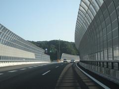
The Yamate Tunnel is a monumental achievement in Tokyo’s urban infrastructure and an essential component of the city’s expressway network. Stretching approximately 18.2 kilometers (11.3 miles) beneath the metropolis, it is Japan’s longest urban road tunnel and a vital segment of the Shuto Expressway’s Central Circular Route (C2). The tunnel alleviates surface congestion, supports sustainable urban development, and connects key districts such as Shinjuku, Shibuya, Ikebukuro, and Shinagawa. Although not open to pedestrians or tourists, understanding the Yamate Tunnel’s significance offers a window into Tokyo’s innovative approach to urban mobility and city planning (urban-institute.info; mlit.go.jp; phongnhaexplorer.com).
Table of Contents
- Introduction
- Historical Evolution and Significance
- Tunnel Alignment, Construction, and Engineering Innovations
- Visitor Information: Hours, Tickets, and Access
- Urban Challenges Addressed by the Yamate Tunnel
- Driving Experience and Travel Tips
- Nearby Districts and Attractions
- Safety Features and Regulations
- Frequently Asked Questions (FAQ)
- Conclusion and Call to Action
- References
Historical Evolution and Significance
Early Urbanization and the Need for Subsurface Solutions
Tokyo’s rapid postwar expansion led to dense development and acute surface congestion, particularly in districts like Shinjuku, Shibuya, and Shinagawa. The city’s geographical constraints—limited flat land encircled by mountains and waterways—made surface expansion impractical (urban-institute.info). Urban planners turned underground, where tunneling became the strategic solution for new expressway routes.
Planning and Conceptualization
The Yamate Tunnel is central to Tokyo’s “Circular Megalopolis Structure,” designed to link major urban centers through a network of expressways forming concentric loops around the city. This approach, formalized in the 1995 Tokyo Plan, aimed to decentralize traffic and reduce the burden on radial routes funneling vehicles into the city core (urban-institute.info).
Construction Milestones and Engineering Innovations
Construction began in the early 1990s, progressing in phases to minimize disruption. The tunnel was constructed with shield tunneling machines, which allowed for safe, efficient boring beneath the city while protecting surface structures. Key safety and environmental features—including advanced ventilation, fire suppression, and real-time monitoring—were incorporated throughout the tunnel (mlit.go.jp). The final section opened in 2015, completing a continuous underground loop around central Tokyo (phongnhaexplorer.com).
Tunnel Alignment, Construction, and Engineering Innovations
- Alignment: Runs approximately 30 meters underground, mostly beneath Yamate Street, from the Takamatsu on-ramp in Toshima to near the Ōi Junction in Shinagawa.
- Length: 18.2 km (11.3 miles)
- Construction: About 70% completed with shield tunneling methods, minimizing surface impact and noise.
- Dimensions: Bore diameter of 11.2 to 13.0 meters; maximum gradient of 6%; minimum curve radius of 204 meters.
- Surface Integration: Above-ground Yamate Street was widened, enabling simultaneous urban redevelopment.
The tunnel’s design avoids demolition of neighborhoods and green spaces, reflecting Tokyo’s commitment to sustainable urban growth.
Visitor Information: Hours, Tickets, and Access
- Access: The Yamate Tunnel is strictly for motor vehicles—cars, taxis, buses—with no pedestrian or bicycle access.
- Visiting Hours: Open 24 hours a day, year-round.
- Tickets/Tolls: No separate ticket is required; tolls are collected as part of the Shuto Expressway system. Fees range from ¥300 to ¥1,320 depending on vehicle type and entry/exit points. ETC (Electronic Toll Collection) cards are widely accepted for payment (Shuto Expressway Official).
- Tours: No public tours or guided visits are available due to safety and operational restrictions.
Note: If you wish to experience the tunnel, you can drive through it using a rental car (with a valid International Driving Permit), taxi, or certain highway buses.
Urban Challenges Addressed by the Yamate Tunnel
- Reduced Congestion: Provides a high-capacity underground bypass, easing traffic on surface streets and older expressways (urban-institute.info).
- Environmental Benefits: Moving traffic underground reduces surface air and noise pollution; advanced tunnel ventilation further minimizes emissions (phongnhaexplorer.com).
- Urban Redevelopment: Frees surface space for parks, pedestrian areas, and new development projects.
- Disaster Resilience: Engineered for seismic safety with reinforced linings and flexible joints (mlit.go.jp).
- Network Integration: Seamlessly connects with other expressways and major districts, enhancing city-wide mobility.
Driving Experience and Travel Tips
- Travel Time: Driving the full length of the tunnel takes about 18 minutes at the speed limit (60 km/h), though congestion can occur during rush hours.
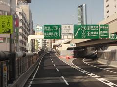
- Navigation: Rental cars and taxis typically have navigation systems with English support. Road signs inside the tunnel are bilingual.
- Payment: Most rental vehicles and taxis are ETC-equipped, making toll payment seamless.
- Tips:
- Avoid peak commuting hours for a smoother drive.
- Always observe speed limits and safety instructions.
- Use real-time traffic apps for optimal route planning.
Nearby Districts and Attractions
Although the tunnel itself is not a sightseeing destination, its endpoints and junctions offer easy access to several of Tokyo’s most popular neighborhoods:
- Shibuya: Famous for the Shibuya Scramble Crossing and vibrant nightlife (Magical Trip).
- Shinjuku: Home to the Tokyo Metropolitan Government Building and extensive shopping.
- Ikebukuro: Known for Sunshine City and entertainment hubs.
- Shinagawa: A key transportation node with parks and waterfronts.
Surface roads like Yamate Dori have been revitalized, making these districts more accessible and pedestrian-friendly.
Safety Features and Regulations
- Emergency Systems: Emergency exits at regular intervals, fire suppression, automated ventilation, and 24/7 surveillance ensure safety (Express.co.uk).
- Prohibited: Stopping or parking (except in emergencies), photography inside the tunnel, and any pedestrian or bicycle access.
- In Case of Emergency: Follow illuminated exit signs and PA system instructions.
Frequently Asked Questions (FAQ)
Q: Can pedestrians or cyclists enter the Yamate Tunnel?
A: No, the tunnel is for motor vehicles only.
Q: What are the toll prices?
A: Tolls range from ¥300 to ¥1,320 for standard passenger vehicles, depending on entry and exit points. Payment is via cash or ETC card.
Q: Are there tours or sightseeing options inside the tunnel?
A: No, tours are not available.
Q: Does public transport use the tunnel?
A: Some highway buses and airport shuttles use the tunnel, but there are no sightseeing routes.
Q: What nearby attractions are accessible via the tunnel?
A: Shibuya, Shinjuku, Ikebukuro, and Shinagawa are all easily accessed via the tunnel’s endpoints.
Conclusion and Call to Action
The Yamate Tunnel is a cornerstone of Tokyo’s urban infrastructure, exemplifying the city’s forward-thinking approach to transportation, environmental stewardship, and urban planning. Though not a conventional tourist attraction, it significantly enhances travel efficiency and quality of life for both residents and visitors. Driving through the tunnel offers a unique perspective on Tokyo’s subterranean ingenuity.
For real-time traffic updates and Tokyo travel tips, download the Audiala app. Explore our related guides to discover more about Tokyo’s landmarks and transportation marvels. Safe travels!
References
- urban-institute.info
- mlit.go.jp
- phongnhaexplorer.com
- Express.co.uk
- Transportation History
- Shuto Expressway Official
- Japan Guide Forum
- Magical Trip
- Tokyo Weekender


