
Historical Evolution of Dukuh Atas
From Orchards to Urban Hub
The name "Dukuh Atas" reflects its origins: "dukuh" means hamlet, "atas" means upper. Once home to duku fruit plantations, the area developed as a trading hub before urbanization took hold. By the 1960s, Dukuh Atas transformed into a bustling nightlife center and food district, drawing crowds from Jakarta’s business core. The district’s split elevation also gave rise to "Dukuh Atas" (upper) and "Dukuh Bawah" (lower), now part of Setiabudi (Wikipedia - Simpang Temu Dukuh Atas).
Modern Transformation
Jakarta’s 2011–2030 Spatial Plan reimagined Dukuh Atas as a high-density, mixed-use district anchored by integrated transport. A 2008 urban design competition, supported by the Japan Bank for International Cooperation, set the blueprint for transforming Dukuh Atas into the city’s model TOD (JICA Urban Transport Hub Report).
Development of Dukuh Atas LRT Station
Strategic Location and Integration
Officially named Dukuh Atas BNI Station in 2024 after a naming partnership with Bank BNI, the station anchors the northern terminus of the Jabodebek LRT’s Cibubur and Bekasi lines. Its location enables direct connections to:
- Jabodebek LRT (Cibubur and Bekasi lines)
- MRT Jakarta (Dukuh Atas BNI)
- KRL Commuter Line (Sudirman Station)
- Airport Rail Link (BNI City Station)
- TransJakarta BRT
The station’s integration with these systems makes it Jakarta’s most comprehensive mobility hub (Detik Finance; Wikipedia - Dukuh Atas TOD).
Naming Rights and Identity
The 2024 rebranding as "Stasiun Dukuh Atas BNI" reflects Jakarta’s strategy to leverage corporate partnerships for transit funding and service improvements. The new name is now featured on signage, maps, and digital platforms (Detik Finance).
Visiting Information: Hours, Tickets, Accessibility
Operating Hours
- Opening 05:00 AM
- Closing 11:00 PM
- Last Train Departures 22:50 (Bekasi), 22:55 (Cibubur)
- Peak Frequency Trains every 10 minutes during rush hours (99.co; Detik Travel)
Ticketing
- Purchase Ticket counters and vending machines at the concourse
- Payment Contactless cards (Jak Lingko, JakCard, Brizzi, Tap Cash, Flazz, eMoney), QRIS, LinkAja, KAI Multi Trip Card, KRL cards (MRTLRTJakarta)
- Fares Start at IDR 5,000 for the first kilometer; additional IDR 700/km; maximum IDR 10,000–25,000 depending on route and day
Accessibility
- Features Elevators, ramps, tactile paving, accessible restrooms, bilingual signage
- Pedestrian Integration JPM Dukuh Atas bridge, Kendal Tunnel, revitalized sidewalks
Station Layout, Connectivity, and Operations
Design and Amenities
- Concourse Ticketing, retail, ATMs, waiting areas, restrooms, nursing rooms, prayer room
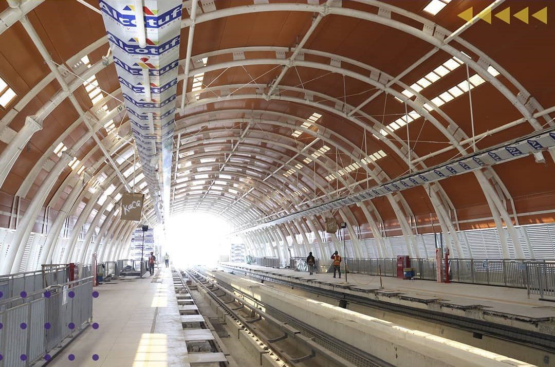
- Platform 200m x 20m with platform screen doors for safety
- Drop-off Zones For private vehicles, ride-hailing, and motorcycle taxis
- Amenities Free charging points, water refill stations, retail kiosks (MRT Jakarta; 99.co)
Connectivity
- LRT Jabodebek Cibubur and Bekasi lines
- MRT Jakarta Underground station, direct access to Bundaran HI and Lebak Bulus
- KRL Commuter Line Sudirman Station, serving Cikarang, Jakarta Kota, Bogor, and Tangerang
- Airport Railink BNI City Station for Soekarno-Hatta Airport
- TransJakarta BRT Corridors 1, 4, and 6
Pedestrian overpasses and tunnels ensure safe, weather-protected transfers (Kompas).
TOD Features
Dukuh Atas’s 146-hectare TOD district includes parks, plazas, office towers, shopping, and revitalized pedestrian infrastructure (1.6 km elevated walkways, 10.6 km sidewalks) (MRT Jakarta).
Nearby Attractions and Activities
- Menteng District Colonial architecture, Bundaran HI (Hotel Indonesia Roundabout)
- Setiabudi CBD Business, dining, and shopping
- Street Food Modern cafes, street food, and bars
- Terowongan Kendal Mural-lined pedestrian tunnel with events
- Taman Dukuh Atas Urban park
- Grand Indonesia & Plaza Indonesia Major malls
- Cultural Sites Monas (National Monument), National Gallery, Kota Tua (Old Town) (Kompas)
Dukuh Atas in Jakarta’s Urban Fabric
Economic and Spatial Role
Dukuh Atas blends high-rise commerce with residential neighborhoods, serving as a flagship for Jakarta’s multimodal, pedestrian-first urban planning (JICA Urban Transport Hub Report).
Transit-Oriented Development
The area exemplifies sustainable development—walkable, mixed-use, and green—supported by international and local urban planners (JICA Urban Transport Hub Report).
Usage Statistics
- Opening August 28, 2023
- Average Daily Users (2024) ~17,573
- Total LRT Jabodebek Users (Aug 2023–Oct 2024) 21.4 million (Detik Finance)
Frequently Asked Questions (FAQ)
Q: What are the visiting hours?
A: 05:00–23:00 daily.
Q: How do I buy tickets?
A: At station counters or vending machines; use contactless cards or cashless options.
Q: Is the station accessible for people with disabilities?
A: Yes—elevators, ramps, tactile paving, and accessible restrooms are provided.
Q: What attractions are nearby?
A: Bundaran HI, Menteng, Grand Indonesia, Taman Dukuh Atas, Monas, Kota Tua.
Q: Are there guided tours or events?
A: Occasional events and exhibitions, especially in the Kendal Tunnel and public spaces.
Visitor Tips
- Avoid peak hours (07:00–09:00, 17:00–20:00) for smoother travel.
- Use transit apps (Moovit, Google Maps) for real-time updates.
- Bring or purchase a contactless card for convenience.
- Dress comfortably for Jakarta’s weather.
- Watch for cultural events in public spaces.
Summary Table of Key Facts
| Aspect | Details |
|---|---|
| Name Origin | From duku fruit plantations; "Atas" means "upper" (elevated location) |
| Historic Use | Fruit trading, nightlife, street food |
| Modern Role | Jakarta’s main integrated TOD hub |
| Naming Rights | Became "Dukuh Atas BNI" in 2024, Bank BNI partnership |
| Integration | LRT, MRT, KRL Commuter Line, Airport Rail Link, TransJakarta |
| Average Users | ~17,573 per day (2024) |
| Location | Border of Central & South Jakarta; near Menteng, Setiabudi CBD |