Plan and listen to Ronda Del Mig with Audiala.
Audio guide in your pocket, itinerary in your browser. Built for the way you actually visit.
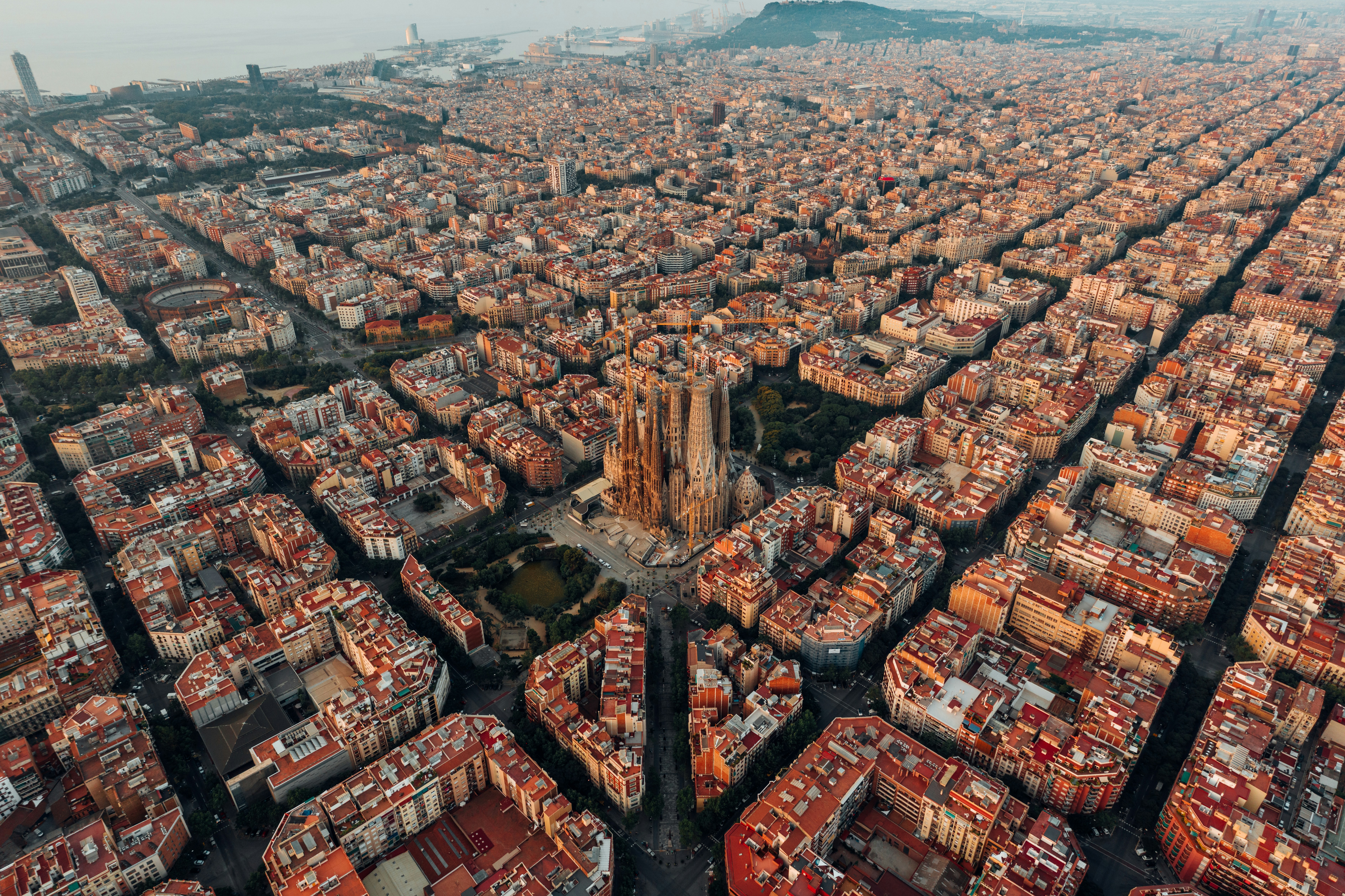
Introduction: Discovering Ronda del Mig in Barcelona
Ronda del Mig is more than just a roadway—it’s a living testament to Barcelona’s century-long journey of urban transformation. Conceived in the early 20th century as part of French urban planner Léon Jaussely’s 1907 master plan, Ronda del Mig was designed to connect disparate neighborhoods and facilitate the city’s expansion beyond its historic core. Instead of being a typical tourist site with set opening hours or ticketing systems, it is a dynamic element of Barcelona’s infrastructure, embodying the city’s ongoing adaptation to demographic, economic, and environmental challenges.
Visitors who explore Ronda del Mig will encounter a route where historical vision meets modern-day urban life. From its ambitious conception, through post-war expansions responding to surging vehicle traffic, to recent interventions prioritizing green spaces and pedestrian access, Ronda del Mig is a gateway to understanding the city’s evolving identity. This guide offers a detailed look at Ronda del Mig’s history, urban significance, practical visiting information, and how it fits into the broader context of Barcelona’s transformation (Wikipedia, SCIRP, Arquitectura Catalana).
Historical Evolution of Ronda del Mig
Early Urban Planning and Conception
Ronda del Mig, known at first as "Primer Cinturó de Ronda," was envisioned in the early 1900s as a pioneering inner ring road to support the expansion of Barcelona. Jaussely’s plan sought to link isolated neighborhoods and enhance the city’s permeability, counteracting the limitations of Barcelona’s fragmented layout (Wikipedia). Realizing this vision took decades, with changing priorities and evolving urban needs continuously shaping the project (SCIRP).
Post-War Expansion and Urban Necessity
The post-WWII era brought rapid population growth and urbanization. Between 1950 and 1970, Barcelona’s urban sprawl and increased motorization necessitated new mobility solutions. Ronda del Mig’s construction in the 1970s was a direct response, offering an alternative to congested avenues like Gran Via de les Corts Catalanes and Aragó, and efficiently connecting neighborhoods from Can Tunis to Guinardó (SCIRP, Vox).
Olympic Urban Transformation
The 1992 Summer Olympics were a catalyst for completing and modernizing Barcelona’s ring road system. Ronda del Mig’s integration into the city’s updated transportation network helped manage increased visitor traffic and shifted mobility patterns, supporting Barcelona’s emergence as a global destination (SCIRP, Vox).
Architectural and Urban Design Interventions
From 1995 to 2003, architects Jordi Henrich i Monràs and Olga Tarrasó Climent led major urban design improvements along Ronda del Mig. Their work focused on humanizing the expressway, introducing green spaces, sculptured landscaping, and pedestrian connections. These interventions have been celebrated for transforming stark viaducts and concrete barriers into inviting urban spaces (Arquitectura Catalana, Barcelofília).
Urban Significance in Contemporary Barcelona
Central Role in Mobility and Connectivity
Ronda del Mig is a backbone for intra-city mobility, absorbing substantial traffic and linking diverse districts while alleviating congestion in the historic city center. Its design accommodates the demands of daily commuters, logistics, and growing traffic from the port and airport (Wikipedia, SCIRP).
Impact on Neighborhoods and Urban Life
The expressway has reshaped the neighborhoods it traverses, integrating areas like Les Corts, Sants, and Gràcia more closely into the city’s social and economic fabric. Urban improvements have added parks, public spaces, and commercial developments, though the road’s scale has also raised concerns about pollution and neighborhood fragmentation (Arquitectura Catalana, Barcelofília).
Adaptation to Modern Urban Challenges
Barcelona is responding to contemporary challenges with sustainability projects such as “superblocks” and plans to cover sections of Ronda del Mig with parks and green space. These efforts aim to reduce car dominance, improve air quality, and reconnect communities (Vox).
Visiting Ronda del Mig: Accessibility, Tours, and Travel Tips
How to Access and Explore
- Public Transport: Metro lines L3 and L5, along with several key bus routes, provide convenient access to Ronda del Mig and nearby neighborhoods.
- On Foot or By Bike: Sections feature wide sidewalks and bike lanes, especially where recent improvements have been made. Use designated crossings and stay on marked paths for safety.
- Guided Tours: Some urban and architectural walking or cycling tours include Ronda del Mig highlights. Check with local operators for availability.
Neighborhoods and Local Life
- Les Corts: Business district, close to Camp Nou.
- Sants: Markets and traditional Catalan eateries.
- Horta-Guinardó: Green spaces and quieter residential streets.
Exploring these neighborhoods provides an authentic experience of Barcelona’s local culture.
Safety and Accessibility
- Ronda del Mig is a functioning roadway; pedestrian access is via sidewalks and crossings. Most areas are accessible for those with reduced mobility, with ramps and accessible metro stations nearby.
- Remain vigilant for traffic and avoid walking on the main expressway.
Practical Tips
- Dining: Enjoy local Catalan cuisine at neighborhood restaurants. Set lunch menus are common and good value.
- Accommodation: Options range from budget hostels to mid-range hotels, especially around Plaça d’Espanya and Les Corts.
- Weather: Visit in spring or early autumn for mild weather and fewer crowds.
- Events: Look out for local festivals and neighborhood fairs, especially in summer.
Connectivity and Essentials
- Pharmacies, supermarkets, and malls like L’Illa Diagonal are within easy reach.
- English is widely understood, but attempting a few Catalan or Spanish phrases is appreciated.
- Use free Wi-Fi in many public areas and consider downloading offline maps for convenience.
Frequently Asked Questions (FAQ)
Q: Does Ronda del Mig have visiting hours or require tickets?
A: No, it is a public expressway accessible at all times, with no entry fees.
Q: Can I walk or cycle along Ronda del Mig?
A: Yes, certain sections feature pedestrian and cycling paths, especially where recent improvements have been made.
Q: Are guided tours available?
A: Some local tour companies include Ronda del Mig in their itineraries—check for current offerings.
Q: Is Ronda del Mig accessible for people with disabilities?
A: Many sidewalks and crossings are accessible; ongoing improvements are being made.
Q: When is the best time to visit?
A: Spring and early autumn offer pleasant weather, but summer is lively with festivals.
Summary: Recommendations for Visiting Ronda del Mig
Ronda del Mig embodies Barcelona’s dynamic approach to urban planning—balancing the demands of mobility, sustainability, and quality of life. Its evolution from an ambitious early 20th-century plan to a modern urban corridor highlights the city’s adaptability and commitment to human-centered design. While challenges such as traffic and neighborhood fragmentation persist, current proposals to cover sections with parks, expand pedestrian zones, and enhance green spaces demonstrate a promising future.
Visitors are encouraged to experience Ronda del Mig not just as a transit route but as a window into Barcelona’s layered urban history. Walk, cycle, or use public transport to explore the neighborhoods it connects, enjoy the evolving public spaces, and gain a deeper appreciation for the city’s ongoing transformation. For personalized itineraries and interactive guides, download the Audiala app and stay updated with the latest urban developments (SCIRP, Vox, Arquitectura Catalana).
Listen to the full story in the app
The whole Ronda Del Mig,
told well.
Audio guides for 1,100+ cities across 96 countries. History, stories, and local insight — offline ready.

Verified, and shown.
Researched and written by the Audiala editorial team from historical records, architectural archives, and local expertise.
Last reviewed