Großhesseloher Brücke: Visiting Hours, Tickets, and Travel Guide to Munich’s Historic Bridge
Date: 04/07/2025
Introduction
The Großhesseloher Brücke is a landmark of Munich, seamlessly integrating historical engineering, scenic beauty, and vibrant urban recreation. This guide offers a comprehensive overview of the bridge’s history, visitor information, and practical tips, making it an essential resource for anyone interested in exploring Munich’s rich heritage.


Table of Contents
- Introduction
- Historical Overview and Significance
- Architectural Evolution and Engineering Innovations
- Wartime History and Preservation
- Modern Reconstruction and Features
- Visitor Information: Hours, Tickets, and Accessibility
- Getting There: Transport and Routes
- Nearby Attractions and Cultural Highlights
- Visitor Tips and FAQ
- Summary and Final Recommendations
- Sources and Official Links
Historical Overview and Significance
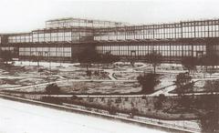
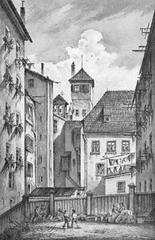
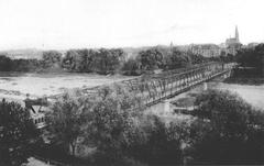
The Großhesseloher Brücke, located in southern Munich, spans the Isar River, connecting the districts of Thalkirchen and Pullach. Originally completed in 1857 as part of the Bayerische Maximiliansbahn, it symbolized Bavaria’s drive toward industrialization and enhanced connectivity with Central Europe (scienceblogs.de, de.wikipedia.org). The bridge’s design, led by Friedrich August von Pauli and Heinrich Gerber, was groundbreaking for its time, combining strength, length, and innovative use of materials (trambahn.org).
Over its long history, the bridge has been reconstructed and modernized multiple times to accommodate heavier trains and increased traffic, always maintaining its role as a vital transport artery and a proud symbol of Munich’s engineering prowess.
Architectural Evolution and Engineering Innovations
19th-Century Origins
The original structure featured lenticular trusses with four main spans and dual railway tracks, a forward-thinking design that anticipated rising transport demands. Massive brick abutments and piers supported the superstructure, making it the world’s highest bridge at the time of its opening (trambahn.org).
20th-Century Upgrades
With heavier trains in the early 1900s, the bridge was rebuilt (1908–1909) with stronger steel trusses and reinforced concrete abutments (de.wikipedia.org). Further renovations in the 1930s, 1940s, and 1960s ensured continued safety and capacity.
Modern Reconstruction
By the 1980s, structural concerns led to a complete rebuilding. The present bridge, inaugurated in 1985, features a robust steel truss design with the railway deck elevated 42 meters above the Isar. Integrated pedestrian and cycle paths, safety fencing, and modern materials make it both functional and accessible (trambahn.org, komoot.com).
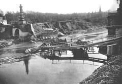
Wartime History and Preservation
During World War II, the bridge nearly faced demolition as Allied forces approached Munich. Thanks to the quick actions of local citizens and a Wehrmacht soldier, planned explosives were removed, saving this vital link and preserving a piece of Munich’s heritage (de.wikipedia.org).
Modern Features and Visitor Experience
Engineering and Safety
- Steel Truss Construction: Ensures high load-bearing capacity for trains and longevity under heavy use.
- Pedestrian and Cycle Paths: Safe, protected lanes run parallel to the rail tracks, connecting to the city’s extensive trail network (komoot.com).
- Safety Mesh Fencing: Prevents access to tracks and enhances visitor safety (muenchenwiki.de).
Scenic Value
The bridge’s height and open design provide panoramic views of the Isar valley, nearby forests, and, on clear days, the Alps. It is a favorite spot for photographers and outdoor enthusiasts alike.
Visitor Information: Hours, Tickets, and Accessibility
- Opening Hours: Open 24/7 for pedestrians and cyclists.
- Tickets: No entrance fee or ticket required for foot or cycle access. Standard S-Bahn tickets apply for train travel across the bridge (Munich Public Transport).
- Accessibility: The bridge’s paths are generally step-free and suitable for wheelchairs and strollers. Some approach routes may have gentle inclines or uneven surfaces.
- Facilities: No restrooms on the bridge; available at nearby S-Bahn stations, parks, or beer gardens.
Getting There: Transport and Access Routes
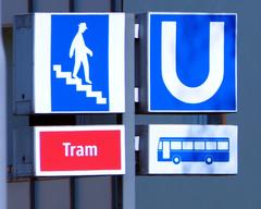
- By Public Transport:
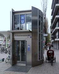
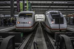
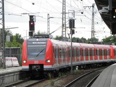
- S-Bahn: S7 line to Großhesselohe Isartalbahnhof or Pullach stations, both within walking distance (Munich Travel).
- Tram: NachtTram1 N27 connects the city center with Großhesseloher Brücke, operating day and night (Moovit N27).
- By Bicycle:
- Connected to the Radl-Ring and Isartalbahn Railway Path, with routes from the city center and along the river (komoot.com).
- On Foot:
- Accessible via numerous hiking trails from Thalkirchen, Pullach, or Solln.
- By Car:
- Limited parking in residential areas; public transport or cycling is recommended.
Nearby Attractions and Cultural Highlights
- Waldwirtschaft Großhesselohe Beer Garden:
Traditional Bavarian food and live music in a scenic riverside setting. - Isar River Trails:
Extensive network for walking, jogging, and cycling. - Hinterbrühler See & Isar Canal:
Picturesque spots for nature walks and picnics. - Old Jewish Cemetery:
A site of cultural reflection and historical significance (Merkur). - Westpark’s Chinese Garden:
A short ride away, offering a tranquil retreat.
Visitor Tips and FAQ
Tips
- Best Times to Visit: Early morning or late afternoon for ideal photography conditions and fewer crowds.
- Weather: The bridge is exposed—dress for the season and bring sun or rain protection.
- Food/Water: Bring refreshments for longer hikes or cycles; nearby districts offer dining options.
- Etiquette: Share the paths with locals, cyclists, and joggers.
Frequently Asked Questions
Q: Do I need a ticket to visit the bridge?
A: No, the bridge is freely accessible. Public transport tickets are required to reach it by tram or train.
Q: Are there set visiting hours?
A: The bridge is open 24 hours a day, year-round.
Q: Is the bridge wheelchair accessible?
A: Yes, though some approach paths may have inclines or uneven surfaces.
Q: Can I cycle across the bridge?
A: Yes, there is a dedicated cycle path.
Q: Are guided tours available?
A: No dedicated tours, but the bridge is included in some local hiking and cycling tours.
Q: Is it safe to visit with children?
A: Yes, but remain on designated paths, as the bridge is high above the river.
Summary and Final Recommendations
The Großhesseloher Brücke is a testament to Munich’s spirit of innovation and adaptation. Its free, round-the-clock accessibility, integration with public transport and recreational networks, and proximity to cultural and natural attractions make it a highlight for any visitor. Enjoy panoramic vistas, explore the Isar valley’s trails, visit local beer gardens, and immerse yourself in one of Munich’s living historical monuments (Munich Travel, komoot.com).
Plan your trip using Munich’s efficient public transportation, check real-time schedules via the Moovit app, and consult digital guides like Audiala for deeper insights and interactive experiences.
Sources and Official Links
- Großhesseloher Brücke: A Historical Marvel and Visitor’s Guide to Munich’s Iconic Bridge, 2025
- Großhesseloher Brücke Wikipedia, 2025
- Großhesseloher Brücke Engineering and History, 2025
- Großhesseloher Brücke Visitor Guide, Munich Travel, 2025
- Großhesseloher Brücke Munich Wiki, 2025
- Großhesseloher Brücke Panoramic Views and Cycling Paths, Komoot, 2025
- Munich Public Transport Information, 2025
- Audiala Mobile App for Munich Tours, 2025
- Moovit N27 Tram
- Merkur: Preservation of Jewish Heritage
For more travel tips, up-to-date event information, and interactive guides, download the Audiala app and follow official Munich tourism channels.