Introduction
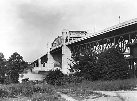
The Knight Street Bridge is a landmark piece of infrastructure connecting Vancouver and Richmond by spanning the north arm of the Fraser River. Since its completion in 1974, it has played a pivotal role in Metro Vancouver’s transportation network, serving as a vital corridor for commuters, commercial vehicles, cyclists, and pedestrians. The bridge offers sweeping views of the Fraser River and the surrounding urban and industrial landscapes, making it a point of interest for infrastructure enthusiasts and visitors seeking unique perspectives of the city.
Open 24/7 with no entry fees or ticket requirements, the Knight Street Bridge is accessible by car, public transit, bicycle, and on foot. Dedicated pedestrian sidewalks and bike lanes provide safe passage and scenic viewing opportunities. The bridge’s robust double-deck design accommodates heavy traffic flows, including significant commercial transportation, while supporting regional sustainability goals through multimodal access.
Although not a conventional tourist attraction, the Knight Street Bridge offers valuable insight into Vancouver’s urban development, engineering ingenuity, and ongoing commitment to resilient infrastructure. The surrounding area also features parks and points of interest that deepen the visitor experience.
For further details on the Knight Street Bridge’s history, engineering, and visitor recommendations, consult resources from the Vancouver Heritage Foundation, TransLink official site, and Metro Vancouver Infrastructure Projects.
History and Cultural Context
The Knight Street Bridge was built to replace the deteriorating Fraser Street Bridge and address the region’s increasing transportation demands. Construction began in 1969 and concluded in 1974. The bridge honors Robert Knight, a historical landowner in South Vancouver whose influence is reflected in the naming of Knight Street, previously known as Knight Road.
Serving as a vital freight and commuter corridor, the bridge catalyzed economic growth and urban expansion in both Vancouver and Richmond. It remains an enduring symbol of the region’s industrial heritage and evolving urban landscape.
Engineering and Structural Features
Bridge Type and Design
- Structure: Cantilevered girder bridge with two distinct spans for northbound and southbound traffic (three lanes each, six in total).
- Dimensions: Main span of 109 meters (358 feet); total bridge length of approximately 1,400 meters (4,593 feet).
- Vertical Clearance: 18.3 meters (60 feet) at high tide, accommodating river navigation.
- Materials: Reinforced concrete and structural steel, with deep pile foundations for stability in the Fraser River delta’s soft soils.
Construction and Upgrades
- Timeline: Built between 1969–1974, replacing the older Fraser Street Bridge.
- Seismic and Safety Upgrades: Retrofitted for earthquake resilience, including reinforced piers, energy-dissipating bearings, and superstructure strengthening.
- Traffic Engineering: Designed for over 100,000 vehicles daily, including high commercial volumes. Features include wide lanes, advanced traffic control, and separation barriers for safety.
- Environmental Considerations: Spaced piers, stormwater management, and landscaping help minimize ecological impact and enhance urban integration.
Maintenance and Longevity
- Ownership: Managed by TransLink since 1999, with regular inspections and ongoing rehabilitation.
- Lifespan: Originally designed for 75 years, with proactive upgrades extending its service well into the future.
Visitor Information: Hours, Access, and Travel Tips
Access and Hours
- Open: 24/7, year-round
- Fees/Tickets: None; public access for vehicles, pedestrians, and cyclists
Getting There
- By Car: Direct via Knight Street (Highway 99A), connecting Vancouver, Richmond, and Delta. Nearby parking is available in parks and commercial areas.
- By Transit: Multiple TransLink bus routes cross the bridge, including the 430 Metrotown/Richmond–Brighouse Express.
- By Bike/On Foot: Dedicated bike lanes and sidewalks offer safe crossings. Pathways along the Fraser River connect with the bridge for pleasant cycling or walking routes.
Accessibility
- Pedestrian and Cyclist Access: Sidewalks on both sides, separated by barriers for safety. Cyclists must use sidewalks, not vehicle lanes.
- Physical Accessibility: Ramps are available at both ends; sidewalks are wheelchair accessible, though the bridge environment is exposed to wind and noise.
- Transit Accessibility: All buses crossing the bridge are accessible.
Safety Tips
- Use designated sidewalks and bike lanes; expect possible detours due to ongoing maintenance.
- Watch for heavy traffic, especially during peak hours.
- There are no amenities or rest areas on the bridge—plan accordingly for longer walks or rides.
Photographic Spots and Nearby Attractions
Best Photo Opportunities
- On the Bridge: Panoramic views of the Fraser River, city skyline, and industrial port activities, especially at sunrise or sunset.
- Nearby Parks: Riverfront Park (Richmond), Vancouver Fraser River Park, and viewpoints along the river offer excellent vantage points for bridge photography.
Nearby Attractions
- Richmond Olympic Oval: A legacy venue from the 2010 Winter Olympics, now a multisport facility.
- Vancouver International Airport: A short drive away for aviation enthusiasts.
- East Van Cross: Iconic public art visible from Knight Street and Clark Drive.
- Fraser River Parks: Riverside trails and picnic areas within walking or cycling distance.
Preservation, Safety, and Modernization
- Seismic Reinforcements: Retrofitted to modern standards for earthquake resilience.
- Traffic and Pedestrian Safety: Upgrades include new safety railings, wider sidewalks, and improved lighting.
- Environmental Initiatives: Ongoing stormwater management and landscaping reduce ecological impact.
- Ongoing Maintenance: Annual inspections and regular repairs ensure long-term safety and reliability.
Frequently Asked Questions (FAQ)
Q: Are there tickets or fees to cross the bridge?
A: No; the Knight Street Bridge is free to use for all travelers.
Q: Is it safe to walk or cycle across the bridge?
A: Yes; dedicated sidewalks and bike lanes are available, but be cautious due to proximity to vehicle traffic.
Q: Are there guided tours?
A: No official tours, but local history and cycling groups occasionally organize excursions that include the bridge.
Q: What are the best times for photography?
A: Early morning and sunset offer the best lighting and less traffic.
Q: Is the bridge accessible for people with disabilities?
A: Yes; sidewalks are wheelchair-friendly, and all transit options on the bridge are accessible.
Q: How can I check for construction or closures?
A: Visit the TransLink official website or the City of Vancouver roadwork page.
Visuals and Media

Alt text: Knight Street Bridge overlooking Fraser River with container ships and industrial landscape.
Interactive Map of Knight Street Bridge and Surrounding Area
Plan Your Visit
The Knight Street Bridge is a testament to Metro Vancouver's commitment to resilient, sustainable, and inclusive urban infrastructure. Whether you are a commuter, cyclist, pedestrian, or visitor, your experience crossing the Knight Street Bridge is enhanced by the surrounding parks, nearby attractions, and the vibrant history of the Fraser River corridor.
For more travel tips, real-time updates, and curated local experiences, download the Audiala app and follow us on social media.
Audiala2024
Listen to the full story in the app
Your Personal Curator, in Your Pocket.
Audio guides for 1,100+ cities across 96 countries. History, stories, and local insight — offline ready.
Audiala App
Available on iOS & Android
Join 50k+ Curators
Sources
- verified
- verified
- verified
- verified
- verified
Last reviewed: