Granville Street Bridge Vancouver: Visiting Hours, Tickets, and Tourist Guide
Date: 03/07/2025
Introduction
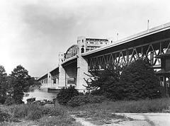
The Granville Street Bridge is a defining feature of Vancouver’s cityscape, representing over a century of urban transformation, engineering achievement, and cultural vibrancy. Linking downtown Vancouver to the southern neighborhoods across False Creek, the bridge is much more than a transportation corridor—it is a living monument to the city’s history, an architectural landmark, and a gateway to bustling districts like Granville Island and the Granville Entertainment District.
This comprehensive guide offers everything you need for a memorable visit: historical context, visiting hours, accessibility features, travel tips, nearby attractions, and details on recent and upcoming upgrades. Whether you are a history enthusiast, architecture buff, cyclist, or casual visitor, the Granville Street Bridge provides an unparalleled vantage point to experience Vancouver’s dynamic spirit and scenic beauty. For the latest information, consult resources such as the City of Vancouver’s official site, Wikipedia, and Destination Vancouver.
Table of Contents
- Granville Street Bridge: Origins and Early Development
- Steel Expansion and Urban Growth (1909–1954)
- Modernization: The Current Bridge (1954–Present)
- Granville Island: Industrial Heritage and Urban Renewal
- Engineering and Architectural Significance
- Visiting Granville Street Bridge: Hours, Access, and Tips
- Recent and Ongoing Transformations
- Frequently Asked Questions (FAQ)
- Visitor Recommendations & Summary
- References and Further Reading
Granville Street Bridge: Origins and Early Development
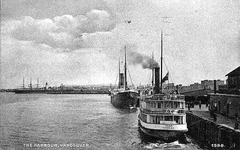
The story of the Granville Street Bridge begins with Vancouver’s rapid expansion in the late 19th century. The original timber trestle, opened in 1889, was constructed by the Canadian Pacific Railway to connect the downtown peninsula with the southern shore of False Creek. This first crossing—2,400 meters (7,900 feet) in length—was vital in extending Granville Street southward, facilitating settlement and economic growth (Wikipedia; Miss604). Its simple structure featured a swing span for marine traffic and a narrow pedestrian path, making it a crucial but modest infrastructure project of its time (Beautiful British Columbia).
Steel Expansion and Urban Growth (1909–1954)
With Vancouver’s population surging to nearly 27,000 by 1901, the original bridge could no longer meet the city’s needs. In 1909, a new steel truss bridge replaced the timber structure, offering a wider deck, improved swing span, and better accommodation for both vehicular and marine traffic (Miss604). The new bridge supported the growing streetcar network and industrial activity, especially around Granville Island, which became a hub for manufacturing and trade (Beautiful British Columbia).
Modernization: The Current Bridge (1954–Present)
The third and present Granville Street Bridge, completed in 1954, marked a leap in urban planning and engineering. Built of steel and concrete, this eight-lane structure stands 27.4 meters above Granville Island, eliminating the need for a swing span and allowing for uninterrupted marine passage (Wikipedia). Designed to anticipate a potential downtown freeway, the bridge’s wide deck and loop ramps reflected mid-20th-century ambitions, though the freeway was never built (Places That Matter). The project reshaped the city’s fabric—demolishing structures like Athletic Park and impacting neighborhoods such as Yaletown—while cementing the bridge’s role as a vital urban connector.
Granville Island: Industrial Heritage and Urban Renewal
Granville Island, beneath the bridge’s southern approach, stands as a testament to Vancouver’s capacity for reinvention. Created in 1916 as an industrial zone, the island was transformed in the late 1970s into a vibrant public space, home to markets, studios, galleries, and performance venues (Traveling Circus of Urbanism). The bridge’s presence has been critical for both the island’s industrial operations and its ongoing appeal as a cultural and recreational destination.
Engineering and Architectural Significance
The Granville Street Bridge is a fixed cantilever/truss structure, forming part of Highway 99 and connecting downtown with Vancouver’s southern neighborhoods (Wikipedia). While utilitarian in design, its sweeping arches offer dramatic city and mountain views, contrasting with the ornate style of neighboring bridges like Burrard. The bridge’s eight lanes and wide sidewalks reflect mid-century planning ideals, while recent seismic retrofits and other upgrades ensure resilience and safety (Miss604; Destination Vancouver).
Visiting Granville Street Bridge: Hours, Access, and Tips
Visiting Hours and Access
- Open 24/7: The bridge is accessible at all hours for pedestrians, cyclists, and vehicles.
- No Tickets Required: Access is free; no admission or ticket is needed.
Accessibility Features
- Pedestrian and Cycling Lanes: Protected lanes and wide sidewalks ensure safety and accessibility for all users.
- Wheelchair and Stroller Access: Smooth pathways and ramps connect the bridge to adjacent neighborhoods and transit routes.
- Ongoing Upgrades: Construction of new ramps and, soon, an elevator to Granville Island will further improve accessibility (CBC News).
Guided Tours and Visitor Information
While there is no dedicated visitor center on the bridge, local heritage organizations offer guided walking and cycling tours that include the bridge and nearby entertainment district. Granville Island’s Public Market, just beneath the bridge, provides visitor information and cultural experiences.
Best Photo Spots
- Mid-Bridge Walkways: Panoramic views of False Creek, Granville Island, downtown, and the North Shore Mountains.
- Sunrise/Sunset: Early and late hours provide dramatic lighting ideal for photography.
- Nearby Parks: David Lam Park and other waterfront spaces offer excellent vantage points.
Nearby Attractions
- Granville Island: Markets, theatres, artisan shops, and waterfront dining.
- Yaletown: Chic neighborhood with shopping, dining, and waterfront parks.
- False Creek Seawall: Scenic walking and cycling routes connecting to major city attractions.
Recent and Ongoing Transformations
The 21st century has seen the Granville Street Bridge become the focus of major urban renewal efforts. The City of Vancouver’s “Granville Connector” project is transforming the bridge into a safer, more inclusive space by:
- Converting two vehicle lanes into protected pedestrian and cycling routes (Granville Island).
- Removing hazardous traffic loops at the north end, replacing them with a standard street grid and new housing (Vancouver Sun).
- Improving accessibility with new ramps, wayfinding, and future elevator access to Granville Island (Pomerleau).
- Focusing on sustainable transport to meet climate goals and encourage active travel (City of Vancouver).
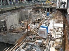
Construction began in early 2023 and is set to conclude by late 2024, with traffic maintained in both directions and minimal disruption to pedestrians and cyclists (CBC News).
Frequently Asked Questions (FAQ)
Q: What are the Granville Street Bridge visiting hours?
A: The bridge is open 24 hours a day, seven days a week, for all users.
Q: Is there a fee or ticket required to cross the bridge?
A: No, the bridge is free and open to all.
Q: Is the bridge accessible for people with disabilities?
A: Yes, with accessible ramps, protected lanes, and future elevator access.
Q: Are there guided tours?
A: While there are no tours dedicated solely to the bridge, many city walking and cycling tours include it as a highlight.
Q: How do I reach Granville Island from the bridge?
A: Access is currently via stairs and ramps; an elevator is in development.
Q: What amenities are available on the bridge?
A: There are no restrooms or seating on the bridge; amenities are available on Granville Island and in nearby parks.
Visitor Recommendations & Summary
The Granville Street Bridge is far more than a functional crossing—it is a living symbol of Vancouver’s evolution, linking neighborhoods, cultures, and eras. Its layered history, striking views, and proximity to attractions like Granville Island and the entertainment district make it a must-visit for anyone seeking to understand and experience Vancouver.
Recent and ongoing upgrades have prioritized safety, accessibility, and sustainability, ensuring the bridge meets the needs of all visitors. Whether you cross by foot, bike, or vehicle, you will find scenic routes, rich history, and easy access to some of the city’s best cultural, culinary, and recreational venues.
Pro Tips:
- Visit at sunrise or sunset for the best photos.
- Use public transit, cycling, or walking paths to avoid traffic and parking challenges.
- Download the Audiala app for guided tours and up-to-date city info.
For construction updates and accessibility information, check the City of Vancouver’s website or CBC News.
References and Further Reading
- Granville Street Bridge: Visiting Guide and Historical Overview of Vancouver’s Iconic Landmark, 2024, Wikipedia
- Granville Street Planning Cultural Heritage Study, 2024
- Granville Bridge Vancouver: Visiting Hours, Upgrades, and Travel Tips for 2025, CBC News
- Granville Street Bridge Visiting Hours, Access, and Vancouver Historical Sites Guide, City of Vancouver
- Granville Island and Urban Renewal, Traveling Circus of Urbanism
- Engineering and Urban Significance of Granville Street Bridge, Places That Matter
- Granville Bridge Interim Connector and North Loops Reconfiguration Project, Pomerleau
- Vancouver Official Tourism Site, Destination Vancouver
For further exploration, visit official tourism sites, download the Audiala app for audio tours, and check out our guides to the Vancouver Seawall, Granville Island, and the city’s best cycling routes.

