Plan and listen to Kiltseva Road, Kyiv with Audiala.
Audio guide in your pocket, itinerary in your browser. Built for the way you actually visit.
Introduction to Kiltseva Road: Historical and Cultural Significance
Kiltseva Road (Ukrainian: Кільцева дорога), commonly known as the Kyiv Ring Road, is a central infrastructural element in Ukraine’s capital. Initially constructed in the 1960s and 1970s to alleviate inner-city congestion and connect key highways, it now functions as a partial orbital route encompassing Kyiv’s western and southern districts. While not a typical tourist attraction, Kiltseva Road is vital for urban mobility, economic activity, and the city’s ongoing expansion. Its evolution mirrors Kyiv’s broader transformation and underscores the importance of integrated urban planning and sustainable transport (World Bank, 2016; Kyiv City Development Strategy until 2025; Mistosite, 2021; EIB Global and Kyiv Transport Projects).
This comprehensive guide explores Kiltseva Road’s origins, current status, and future prospects. Whether you are a local resident, an urban planner, or a traveler interested in Kyiv’s infrastructure and access to nearby attractions, this resource will help you navigate Kiltseva Road safely and efficiently.
Historical Evolution of Kiltseva Road
Origins and Early Development
Kiltseva Road was a Soviet-era project, initiated in the mid-20th century to accommodate Kyiv’s rapid urbanization. Designed as a bypass, it linked the city’s expanding residential and industrial zones while connecting major highways like the M06 (Kyiv–Chop), M07 (Kyiv–Kovel), and M05 (Kyiv–Odesa). The term “Kiltseva” means “ring” in Ukrainian, referencing its role as a semi-orbital thoroughfare (World Bank, 2016).
Soviet and Post-Soviet Expansion
With economic growth and rising car ownership in the late Soviet and post-independence eras, Kiltseva Road expanded. This growth spurred the development of commercial districts, logistics hubs, and residential communities along its corridor, though infrastructure often lagged behind urban demand (World Bank, 2016).
Modern Developments and Urban Significance
Infrastructure Upgrades and Urban Planning
The 21st century has seen targeted modernization, including:
- Widening of roadways, especially near commercial centers.
- Construction of multi-level interchanges to address congestion.
- Integration of public transport (buses, marshrutkas) and gradual improvements for pedestrians and cyclists (Mistosite, 2021).
- Ongoing challenges in standardizing infrastructure due to administrative fragmentation between Kyiv City and Kyiv Oblast (World Bank, 2016).
Commercial and Social Transformation
Today, Kiltseva Road is lined with shopping malls (MegaMarket, Epicentr K, Lavina Mall), business parks, and residential developments. This axis supports Kyiv’s suburban growth but also contributes to traffic and environmental pressures.
Strategic Role in Mobility
Kiltseva Road diverts through-traffic from central streets like Khreshchatyk, facilitates logistics, and has served as a key corridor for humanitarian aid during crises (World Bank, 2016).
Visitor Information: Navigating Kiltseva Road
Traffic and Transport Routes
- Peak Hours: 8:00–10:00 and 17:00–19:00, especially near interchanges and shopping centers.
- Public Transport: Multiple bus and marshrutka lines traverse the road, connecting to metro stations and suburbs.
- Cycling and Walking: Infrastructure is improving, but gaps remain. Plan ahead for safe routes.
Accessibility and Safety
- Use official taxis or public transit—walking along Kiltseva Road is not recommended at night.
- Pedestrian crossings and nighttime lighting vary; exercise caution.
Visiting Hours and Tickets
Kiltseva Road is a public route, open 24/7 with no ticket requirements. Check real-time updates for construction or traffic advisories.
Points of Interest Near Kiltseva Road
- Shopping Malls: MegaMarket, Lavina Mall, Epicentr K.
- Parks: Green spaces and recreational areas are accessible from the ring road.
- Dining: Roadside cafes and eateries offer local and international cuisine.
Visual Aids and Maps
Interactive maps are available on Kyiv’s transit websites and popular navigation apps, highlighting the Kiltseva Road route and nearby attractions.
Urban Planning Challenges and Future Prospects
Governance and Coordination
Development is complicated by fragmented governance between city and province, leading to inconsistent road quality and planning (World Bank, 2016).
Sustainable Mobility and Future Expansion
Urban planners advocate for green infrastructure, integrated land use, and enhanced public participation. Planned improvements include:
- Completing the ring as a full orbital highway.
- Smart traffic management and expanded public transport integration.
- Extension of cycling and pedestrian infrastructure (Mistosite, 2021).
Nearby Attractions and Kyiv Tourist Highlights
While Kiltseva Road itself is not a tourist site, it provides access to many of Kyiv’s most important attractions:
- Kyiv Pechersk Lavra: UNESCO-listed monastery, open daily 9:00–17:00 (official site).
- Saint Sophia’s Cathedral: Renowned for its mosaics and frescoes, open 10:00–18:00 (closed Mondays) (official website).
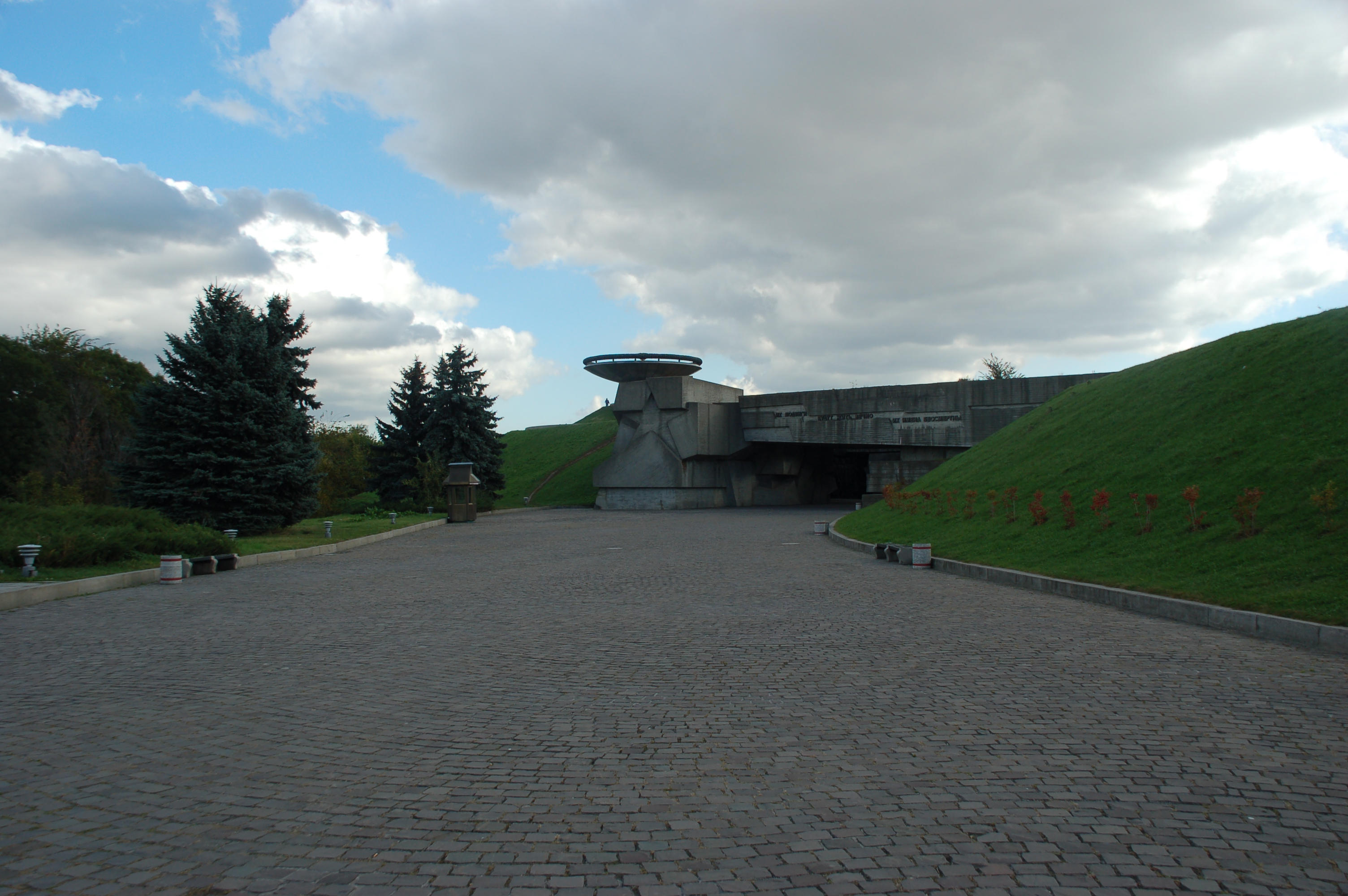
- Motherland Monument: Iconic WWII memorial and museum, open 10:00–18:00; observation deck available (Official Museum Website).
- Andriyivskyy Descent: Vibrant historic street with art galleries and crafts.
- Holosiivskyi National Nature Park: Adjacent to the southern ring, ideal for recreation.
- Pirogovo Open-Air Museum: Folk architecture and life, south of Kiltseva Road.
- Chernobyl Exclusion Zone: Accessible for day tours via M06 (official tour providers).
Shopping and Local Experiences
- Shopping Centers: Offer a blend of Ukrainian and international brands.
- Markets: Provide fresh produce, local crafts, and street food.
- Dining: Sample Ukrainian dishes such as borscht, varenyky, and chicken Kyiv.
Safety Considerations for Visitors
- General Safety: Kyiv is generally safe, but remain alert in crowded places and after dark.
- Crime: Pickpocketing may occur in busy areas; violent crime is rare.
- Road Safety: Heavy traffic—use designated crossings and be mindful as a pedestrian or cyclist.
- Transport: Use reputable taxis or rideshare apps (Uklon, Bolt).
- Health: Medical facilities are accessible; carry travel insurance.
- Political Climate: Monitor local news for demonstrations or advisories.
Cultural Insights Around Kiltseva Road
- Urban Fabric: Mix of Soviet-era and modern architecture.
- Local Life: Vibrant markets, diverse neighborhoods, and authentic Ukrainian hospitality.
- Language: Ukrainian is official, Russian is common, and English is increasingly spoken in service sectors.
- Festivals: Local fairs and events celebrate Ukrainian culture along the corridor.
FAQ
Q: Is Kiltseva Road open 24/7?
A: Yes, it is always open to vehicles and public transport.
Q: Are there pedestrian or cycling routes?
A: Some sections have dedicated paths; infrastructure is expanding but not continuous.
Q: How can I reach attractions from Kiltseva Road?
A: Use public transport or taxis for convenient connections to major sites.
Q: Are guided tours available for nearby landmarks?
A: Yes, tours are offered for sites like Kyiv Pechersk Lavra and Chernobyl.
Q: What languages are spoken?
A: Ukrainian and Russian are most common; English is used in tourist areas.
Listen to the full story in the app
The whole Kiltseva Road, Kyiv,
told well.
Audio guides for 1,100+ cities across 96 countries. History, stories, and local insight — offline ready.

Verified, and shown.
Researched and written by the Audiala editorial team from historical records, architectural archives, and local expertise.
Last reviewed