Cần Thơ Bridge: Visiting Hours, Tickets, and Travel Guide
Date: 14/06/2025
Introduction
Spanning the majestic Hậu River in Vietnam’s Mekong Delta, Cần Thơ Bridge is not only a marvel of modern engineering but also a symbol of the region’s economic vitality and cultural transformation. As the longest cable-stayed bridge in Southeast Asia, this structure has revolutionized transportation and regional connectivity since its completion in 2010. More than a practical crossing, it offers visitors sweeping views of the Mekong waterways and serves as a gateway to Cần Thơ’s vibrant urban and rural attractions (Vietnam Tourism; Wikipedia).
This guide provides comprehensive information on Cần Thơ Bridge’s history, design, visitor access, accessibility, and tips for exploring nearby attractions. Whether you’re a first-time visitor or a returning traveler, this article will help you plan an enriching journey.
Table of Contents
- Introduction
- History and Significance
- Construction and Engineering
- Visiting Information
- Architectural Highlights
- Regional Impact and Economic Benefits
- Nearby Attractions
- FAQs
- Visitor Etiquette and Safety
- Visuals and Media Suggestions
- Summary and Recommendations
- References
History and Significance
The Need for a Modern Crossing
Before Cần Thơ Bridge, the only way to cross the Hau River—a key distributary of the Mekong—was by ferry. These crossings were slow, often crowded, and vulnerable to weather disruptions. The rapid growth of the Mekong Delta region and increased trade volume made a reliable bridge crossing essential for linking Cần Thơ City with Vĩnh Long Province and facilitating broader connectivity (Vietnam Tourism).
Planning and International Collaboration
The bridge was envisioned as part of the Mekong Delta Transport Infrastructure Development Project. Planning began in the 1990s, with significant financial and technical support from the Japanese government through the Japan International Cooperation Agency (JICA). This collaboration marked a milestone in Vietnam-Japan relations and set new standards for large-scale infrastructure in the region (JICA).
Construction and Engineering
Timeline and Key Features
- Start of Construction: September 2004
- Main Span: 550 meters
- Total Length: 2,750 meters
- Clearance Height: 39 meters for vessel passage
- Opening: April 24, 2010 (Wikipedia)
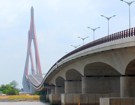
The bridge’s cable-stayed design was chosen to minimize supports in the river, reducing environmental and navigational impact. Two inverted Y-shaped pylons rise 164.8 meters, supporting the main span with 128 cable stays. The deck accommodates four traffic lanes and two pedestrian walkways (supertravelr.com).
Foundation System
The bridge is anchored by bored piles up to 94 meters deep—the largest and longest in Vietnam at the time. Each pile incorporates approximately 45 tons of steel and 500 cubic meters of concrete (cantho.gov.vn).
Safety Lessons
On September 26, 2007, a temporary scaffolding collapse resulted in 55 fatalities, marking one of Vietnam’s worst construction accidents (BBC News). This tragedy led to rigorous safety reviews and improved construction standards for subsequent phases and future projects (Sustainable Construction Review).
Visiting Information
Hours and Tickets
- Visiting Hours: Open 24 hours a day, 7 days a week
- Tickets: No entrance fee for pedestrians. Vehicle tolls apply as per highway regulations.
Accessibility
- Pedestrian Walkways: Dedicated lanes for safe walking and cycling.
- Disabilities: While accessible, the bridge is long and lacks shaded areas or rest stops. For those with mobility challenges, nearby viewpoints like Ninh Kiều Wharf are recommended.
- Getting There: Accessible via taxi, motorbike, local bus, or organized tours. The bridge is about 5 km from Cần Thơ city center (WildTrips).
Travel Tips
- Best Visiting Times: Early morning or late afternoon for pleasant weather and lighting.
- Weather: Dry season (December–April) is most comfortable. Rainy season (May–November) may bring brief but heavy showers (GoNetoVietnam).
- What to Bring: Sun protection, water, comfortable shoes, and a camera.
Architectural Highlights
Cần Thơ Bridge stands out for its clean cable-stayed lines and dramatic red illumination at night. The pylons’ inverted Y-shape is both structurally efficient and, according to tradition, reminiscent of praying hands—a subtle nod to regional spiritual symbolism (cantho.gov.vn).
The bridge’s LED lighting system creates a vibrant nighttime display, making it a focal point for evening strolls and photography (VinWonders).
Regional Impact and Economic Benefits
Economic Transformation
Cần Thơ Bridge is a key link in National Route 1A, facilitating rapid and cost-effective movement of goods and people throughout the Mekong Delta. Its 39-meter clearance allows large ships to pass, supporting logistics for Vietnam’s agricultural exports (VinWonders).
The bridge has spurred investment in logistics hubs, new industrial zones, and urban development, helping modernize the local economy (Luxury Cruise Mekong).
Social and Cultural Impact
The bridge has improved access to education, healthcare, and jobs for communities on both banks, and has become an emblem of progress and unity. Its image is now synonymous with Cần Thơ’s modern identity (JICA).
Nearby Attractions
- Ninh Kiều Wharf: Riverside promenade, boat tours, and city views (VietnamTravel.com).
- Cần Thơ Pedestrian Bridge (Love Bridge): S-shaped, LED-lit, popular for evening walks (Mytour.vn).
- Cần Thơ Artificial Beach: Family-friendly recreation area on the riverbank (Mytour.vn).
- Cai Rang Floating Market: Lively morning market accessible by boat from Ninh Kiều Wharf (Fiona Travels from Asia).
- Bang Lang Stork Sanctuary: Birdwatching haven, 45 km away (Asia Tour Advisor).
- Binh Thuy Ancient House: Historic colonial mansion (Uncover Vietnam).
- Can Tho Central Market: Bustling local market for food and crafts (WildTrips).
FAQs
Q: What are the visiting hours for Cần Thơ Bridge?
A: The bridge is open to the public 24/7.
Q: Is there an entrance fee or ticket?
A: No, there is no fee for pedestrians.
Q: Are guided tours available?
A: Several local operators include the bridge in city or Mekong Delta tours.
Q: Is the bridge accessible for people with disabilities?
A: Pedestrian lanes are available, but direct accessibility features (ramps, rest areas) are limited.
Q: Where can visitors get the best views?
A: Midpoint of the bridge, Ninh Kiều Wharf, or the artificial beach area.
Visitor Etiquette and Safety
- Use dedicated pedestrian lanes and remain alert to traffic.
- Respect local customs and avoid littering.
- Follow traffic regulations; do not obstruct vehicle lanes.
Visuals and Media Suggestions
- Daytime and night photos showcasing LED lighting.
- Drone footage or panoramic images from Ninh Kiều Wharf.
- Maps highlighting the bridge’s location and nearby attractions.
Summary and Recommendations
Cần Thơ Bridge is a transformative structure both for the Mekong Delta’s infrastructure and its identity. Its accessibility, iconic design, and role in regional development make it a must-visit for travelers. Combine your visit with stops at floating markets, historic houses, and vibrant night markets for a full Cần Thơ experience. For real-time tips and exclusive offers, download the Audiala app and follow our social media channels (Vietnam Tourism; Supertravelr).
References and Further Reading
- Vietnam Tourism
- Wikipedia
- Supertravelr
- Cantho.gov.vn
- Vietnam News
- VinWonders
- Sustainable Construction Review
- Luxury Cruise Mekong
- WildTrips
- VietnamTravel.com
- Fiona Travels from Asia
- GoNetoVietnam
- Uncover Vietnam

