Punta Manara Visiting Hours, Tickets, and Travel Guide: Sestri Levante Historical Sites
Date: 14/06/2025
Introduction: Why Visit Punta Manara in Sestri Levante?
Punta Manara is a striking promontory on the Ligurian coast, adjacent to the picturesque town of Sestri Levante, Italy. This protected natural area seamlessly blends breathtaking Mediterranean landscapes, significant historical landmarks, and vibrant local culture. With panoramic views over the Gulf of Tigullio and direct ties to ancient, medieval, and modern Ligurian history, Punta Manara is an essential destination for hikers, nature lovers, and cultural explorers alike. Its trails wind through aromatic maquis shrubland, lead to the ruins of a medieval watchtower, and connect visitors to the legacy of the Liguri Tigulli tribe and centuries of maritime defense (lecinqueterre.org; wikipedia).
Punta Manara is open year-round and freely accessible. Well-marked hiking trails offer both moderate and challenging routes, all framed by unique geological features and diverse flora including holm and cork oaks, maritime pines, and wild herbs. The promontory is further enriched by its proximity to Sestri Levante’s charming old town, the celebrated Baia del Silenzio, and cultural highlights like the Hans Christian Andersen Festival (In Viaggio con Monica; lamialiguria.it).
This guide offers a comprehensive overview of Punta Manara: its history, nature, visitor information, hiking tips, and local attractions, ensuring you have everything you need for an enriching Ligurian adventure (sestrilevanteligure.com; italianvisits.com).
Historical Background and Significance
Ancient Origins and Early Settlement
The earliest roots of Punta Manara can be traced to the Liguri Tigulli, who inhabited the promontory and its surroundings before Roman times (lecinqueterre.org). Its elevation and proximity to maritime routes made it a strategic location for lookout and defense, a role that continued as Sestri Levante (then Segesta Tigulliorum) became a Roman-era trading hub (wikipedia).
Medieval Fortifications and Maritime Defense
During the Middle Ages, Punta Manara became a linchpin in coastal defense, with the construction of a watchtower that remains visible today. This structure formed part of Genoa’s wider system of fortifications against Saracen and Turkish pirates. The promontory also witnessed conflicts between Genoa and Pisa, and was periodically threatened by other regional powers (lecinqueterre.org; wikipedia).
Environmental and Geopolitical Significance
Punta Manara’s rocky, triangular shape and sandstone geology reflect millions of years of tectonic activity (peakvisor.com). Its slopes provide vital water sources, supporting olive groves and small-scale agriculture in the adjacent village of Ginestra. The combination of rugged natural features and strategic views has long influenced its historical and environmental importance (wikipedia).
Modern Era: From Military Outpost to Protected Area
The promontory was used for military purposes even into World War II, with remnants of fortifications still visible in the pine woodlands (wikipedia). In 1977, Punta Manara was designated a protected natural area, preserving its 190 hectares of holm oak forests, Mediterranean maquis, and historical ruins (peakvisor.com).
Cultural Legacy and Literary Connections
Sestri Levante’s literary and artistic heritage is closely tied to Punta Manara. Hans Christian Andersen’s stay in 1833 inspired the naming of Baia delle Favole and continues to be celebrated during the annual Andersen Festival (sestrilevanteligure.com). The promontory thus remains not just a historical site but a vibrant part of local cultural life.
Visiting Punta Manara: Essential Information
- Visiting Hours: Open daily from dawn to dusk, year-round.
- Tickets & Fees: No entrance fee; access is free. Guided tours may be available through local operators.
- Accessibility: Only accessible by footpaths from Sestri Levante. Trails are moderate but not wheelchair accessible.
- Guided Tours: Available seasonally; inquire at the Sestri Levante tourist office.
- Nearby Attractions: Sestri Levante’s old town, Baia del Silenzio, the medieval castle, and local beaches.
Conservation and Sustainable Tourism
As a protected natural area, Punta Manara is home to diverse flora and fauna, including birds of prey and small mammals. Visitors are expected to stay on marked trails, carry out trash, and avoid disturbing wildlife (peakvisor.com; wikipedia).
Hiking Guide: Location, Topography, and Trail Details
Location and Topography
Punta Manara rises between Sestri Levante and Riva Trigoso, reaching heights of up to 178 meters above sea level and dividing the Baia del Silenzio from the Golfo di Riva Trigoso. The main trail begins in Sestri Levante (Vico del Bottone off Via XXV Aprile) and ascends through terraced gardens, olive groves, and Mediterranean scrub. The route is about 3 km one way, with an elevation gain of 170 meters (Sara in Italia).
Vegetation and Ecosystem
The area is dominated by Mediterranean maquis: holm and cork oaks, olive trees, pines, and aromatic shrubs. The biodiversity supports a range of wildlife, from seabirds to mammals, in a relatively undisturbed habitat (In Viaggio con Monica).
Geological Features
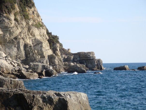
Punta Manara’s sandstone and marl cliffs are shaped by centuries of wind and sea erosion. Notable geosites include the Ciappa du Lu, a striking rock formation near the summit (In Viaggio con Monica).
Panoramic Viewpoints
Rest areas and benches along the trail provide sweeping vistas of Sestri Levante, Riva Trigoso, and the Ligurian Sea. The summit, marked by the Saracen watchtower ruins, offers the most spectacular views (Sara in Italia).
Trail Network and Accessibility
- Main Trail: Well-marked with red squares; moderate difficulty, suitable for most visitors.
- Extended Routes: Options include a loop around Monte Castello (more challenging) or a descent to Riva Trigoso with train return.
- Trail Duration: 1 hour ascent; 2–2.5 hours round-trip with stops.
- Facilities: Picnic tables at Bivacco Manara and benches at viewpoints.
- Safety: Sturdy shoes essential, especially after rain; supervise children near cliffs.
- Refreshments: Bring water and food; no facilities on the trail (In Viaggio con Monica).
- Transport: Sestri Levante train station is a 10-minute walk from the trailhead (Sara in Italia).
Coastal and Marine Environment
The cliffs drop steeply into the Ligurian Sea, with coves ideal for swimming and snorkeling. The nearby Baia del Silenzio offers sheltered, sandy beaches (Sara in Italia).
Climate and Best Times to Visit
Best in spring (April–June) or autumn (September–October) when weather is mild and trails are less crowded. Summer is hot and busy; winter is mild but can be slippery after rain (In Viaggio con Monica).
Practical Visitor Information
- Getting There: Sestri Levante is reachable by train (45 min from Genoa), car (A12 highway), or from Genoa Airport (sestrilevanteligure.com; discovergenoa.com).
- Trailhead: Vico del Bottone or Salita della Mandrella in Sestri Levante.
- Amenities: Public restrooms in town only; no shops or cafés on the trail.
- Accommodation: Hotels, B&Bs, and rentals available in Sestri Levante (sestrilevanteligure.com).
- Guided Tours: Local guides offer hiking and cultural tours (italianvisits.com).
- Pets: Dogs allowed on a leash.
- Emergency: Dial 112 for assistance (touristsecrets.com).
Hiking Trails and Outdoor Activities
Main Hiking Routes
- Punta Manara Loop: 9 km, moderate, 2.5–3 hours. Panoramic views, historical sites, and access from Sestri Levante’s center (wikiloc.com).
- Sentiero Liguria Stage 7: Sestri Levante – Punta Manara – Riva Trigoso – Moneglia, 12 km, 4–5 hours.
- Monte Castello Loop: More challenging, with added elevation and forested trails.
Outdoor Pursuits
- Climbing: Crags rated 3b–7b+.
- Biking: Suitable for experienced mountain bikers (lamialiguria.it).
- Running and Nordic Walking: Varied terrain and scenery (komoot.com).
- Birdwatching: Rich in native and migratory species.
Local Events
Participate in the Hans Christian Andersen Festival, “Pane e Olio” culinary event, and seasonal guided hikes (lamialiguria.it).
Frequently Asked Questions (FAQ)
Q: What are the visiting hours?
A: Open daily from dawn to dusk, year-round.
Q: Is there an entry fee?
A: No, entry is free.
Q: Are guided tours available?
A: Yes, especially in peak seasons; check with the tourist office.
Q: Is the trail suitable for children?
A: Yes, for those comfortable with moderate hiking. Watch children near cliffs.
Q: Are dogs allowed?
A: Yes, on a leash.
Q: Where are the nearest amenities?
A: In Sestri Levante town, at the trailhead.
Q: Are there swimming opportunities?
A: Yes, in coves and at Baia del Silenzio.
Visual Recommendations & Media
- Include panoramic photos of the summit, Saracen tower ruins, and Mediterranean vegetation.
- Use descriptive alt text for all images, e.g., “View from Punta Manara summit overlooking Baia del Silenzio”.
Internal and External Links
Find more on the official Liguria tourism site and related articles on hiking and coastal attractions.
Call to Action
Download the Audiala app for trail maps, guided tours, and local insights. Follow us on social media for updates, travel tips, and event information. Begin your Ligurian adventure today!
References
- lecinqueterre.org
- wikipedia
- In Viaggio con Monica
- lamialiguria.it
- sestrilevanteligure.com
- Sara in Italia
- peakvisor.com
- italianvisits.com
- wikiloc.com
- komoot.com
- discovergenoa.com
- touristsecrets.com
