Douglas Road Miami Visiting Hours, Tickets, and Historical Sites Guide
Date: 04/07/2025
Introduction to Douglas Road Miami
Douglas Road, officially designated as Southwest 37th Avenue, is a historic and culturally significant corridor weaving through Miami-Dade County. Traversing neighborhoods like Coral Gables, Coconut Grove, and Little Havana, it is both a vital transportation artery and a vibrant showcase of Miami’s rich multicultural heritage. Named either after William Douglas or the iconic Douglas Entrance—an emblem of Miami’s 20th-century Mediterranean Revival urban design—Douglas Road has played a pivotal role in shaping the city’s development by linking residential, commercial, and transit hubs. Today, it is celebrated not only for its historical landmarks and diverse communities but also for its integration into modern transit-oriented developments like the Link at Douglas (Douglas Road Miami: History, Key Landmarks, Visiting Hours, and Visitor Guide; Florida YIMBY).
Featuring accessible public transportation, pedestrian-friendly streetscapes, and connections to The Underline urban trail, Douglas Road invites exploration for architecture enthusiasts, culture seekers, and urban adventurers alike. This guide delivers in-depth information on Douglas Road’s history, visitor essentials, ticketing, transportation, and cultural highlights, equipping travelers and locals to experience this unique Miami corridor with ease.
Table of Contents
- Introduction
- Historical Background
- Route Description
- Visiting Douglas Road Miami: Practical Information
- Notable Landmarks and Points of Interest
- Urban Evolution and Transit-Oriented Development
- Top Attractions & Things to Do
- Getting There and Around
- Practical Visitor Information
- Frequently Asked Questions
- Conclusion
- References
Historical Background
Origins and Naming
Douglas Road, also known as West 37th Avenue, is a critical north–south corridor with roots in Miami’s early urban expansion. Its name is attributed either to William Douglas, a key figure in Miami’s development, or the Douglas Entrance—a historic Mediterranean Revival archway symbolizing the city’s planned growth ethos (Wikipedia: Douglas Road (Miami)). As Miami evolved from agricultural beginnings into a thriving metropolis, Douglas Road became a connective thread linking key neighborhoods and commercial nodes.
Role in Urban Development
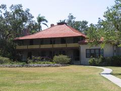
Beginning in the early 20th century, Douglas Road shaped the growth of neighborhoods like Coconut Grove and Coral Gables. The 1924 construction of the Douglas Entrance, now listed on the National Register of Historic Places, remains a signature of George Merrick’s vision for Coral Gables as a grand, Mediterranean-inspired city. Throughout the decades, Douglas Road provided access to significant destinations such as the University of Miami, Miracle Mile, and various historic districts, cementing its status as a transportation and community hub (Wikipedia: Douglas Road (Miami)).
Cultural and Social Impact
Douglas Road traverses multicultural neighborhoods, reflecting Miami’s diverse Cuban, Bahamian, and Caribbean influences. Historically, it also marked social and racial boundaries, but has since become a symbol of resilience and inclusivity, hosting thriving businesses, churches, and cultural institutions.
Route Description
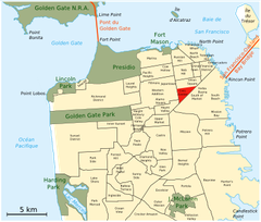
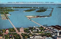
Southern Terminus & Key Crossings
Douglas Road begins at Edgewater Drive in Coral Gables near Coconut Grove, close to Biscayne Bay. Progressing north as SW 37th Avenue, it quickly meets South Dixie Highway (US 1), a major Miami artery. Further north, it borders Miami and Coral Gables, intersecting:
- Bird Road (SR 976): Local shopping and dining.
- Coral Way (SR 972): Tree-lined, historic architecture.
- Tamiami Trail (US 41): Gateway to the Everglades and Gulf Coast.
- Flagler Street (SR 968): Miami’s grid baseline and commercial center.
Miami River & Northern Segments
Crossing the Miami River, Douglas Road transitions from leafy neighborhoods to more commercial and industrial zones near Miami International Airport. The road experiences discontinuity at the river, resuming northward through NW 79th Street to the Miami Amtrak station, with an additional segment near NW 103rd to 106th Streets.
Extension into Broward County
Douglas Road’s final stretch starts at Ali Baba Avenue in Opa-locka, passes the Miami–Opa Locka Executive Airport, continues through Miami Gardens, and extends into Broward County as SW 89th Avenue and Coral Springs Road. Its total span is approximately 20.4 miles (32.8 km) (Wikipedia: Douglas Road (Miami)).
Visiting Douglas Road Miami: Practical Information
Visiting Hours & Accessibility
- Douglas Road: Open 24/7 as a public roadway.
- Douglas Entrance: 8:00 AM – 8:00 PM, daily, free admission.
- Miracle Mile Shops/Restaurants: 10:00 AM – 10:00 PM (varies by business).
- Douglas Road Metrorail Station: 5:00 AM – midnight, fully accessible.
The corridor is served by Metrorail, Metrobus, and free trolley routes. Bike lanes and sidewalks are prevalent in Coral Gables and Coconut Grove. Parking is generally accessible near major attractions.
Ticket Information
No ticket is required to explore Douglas Road or visit public spaces like the Douglas Entrance. Admission fees may apply at nearby institutions or for guided tours; check individual sites for details.
Travel Tips
- Best Times: Weekdays during daylight for a quieter experience.
- Transit: Use Douglas Road Metrorail Station for public access.
- Safety: Standard urban precautions are advised.
- Nearby Attractions: Coconut Grove parks, Little Havana, Coral Gables district.
Notable Landmarks and Points of Interest
- Douglas Entrance: Historic Mediterranean Revival archway.
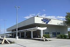
- Douglas Road Metrorail Station: Key transit hub (Miami Metrorail).
- Miracle Mile: Upscale shopping and dining district.
- Miami International Airport: Near the northern segment.
- Opa-locka Executive Airport: Close to the northern extension.
Urban Evolution & Transit-Oriented Development
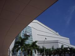
Link at Douglas: A Model for Mixed-Use Urbanism
The Link at Douglas is a transformative, multi-phase development adjacent to the Douglas Road Metrorail Station. Spanning 7 acres, it exemplifies Miami’s embrace of transit-oriented, mixed-use growth (Florida YIMBY). Key features include:
- Residential Towers: Over 1,500 apartments (with at least 12.5% workforce housing).
- Retail & Amenities: 30,000+ sq. ft. of retail space, including Milam’s Market.
- Public Improvements: $17 million invested in station and plaza upgrades, interfacing with The Underline urban trail.
The Underline & Public Transit Integration
The Douglas Road Metrorail Station connects with The Underline—a 10-mile urban park and trail beneath the Metrorail. This integration encourages sustainable, car-free mobility and active lifestyles (Miami Wire).
- Station Hours: 5:00 AM – midnight; accessible.
- The Underline Trail: Open dawn to dusk, wheelchair-friendly.
Cultural Connectivity & Public Art
Douglas Road stations and corridors are enlivened by murals and public art, reflecting Miami’s multicultural ethos. Riders and visitors experience a blend of languages and cultures daily (Miami Wire).
Neighborhood Influence: Coral Gables & Coconut Grove
- Coral Gables: Mediterranean architecture, Miracle Mile, Coral Gables Museum, vibrant dining (Miami and Beaches).
- Coconut Grove: Miami’s oldest neighborhood, artsy vibe, parks, and cafes (Lonely Planet).
Economic and Cultural Impact
Revitalization along Douglas Road, especially through projects like Link at Douglas, supports local entrepreneurship, creates jobs, and draws both residents and tourists. Enhanced connectivity to attractions such as Vizcaya Museum and Miracle Mile boosts the area’s appeal (Amber Student).
Ongoing and Future Developments
The completion of CORE and CASCADE towers, alongside the forthcoming CADENCE and a fourth tower, will add hundreds of new residential units and retail spaces, ensuring Douglas Road’s continued evolution as a model for sustainable, inclusive growth (Florida YIMBY).
Top Attractions & Things to Do
Miracle Mile & Coral Gables
Stroll Miracle Mile for upscale retail, art galleries, and dining. Visit nearby Coral Gables Museum and the Venetian Pool. Douglas Road provides excellent access to these landmarks.
Downtown Miami Connectivity
Miami Worldcenter, though northeast of Douglas Road’s downtown end, enhances corridor connectivity with pedestrian-friendly design, hotels, and entertainment venues.
Dining & Shopping
- Boustan: Middle Eastern cuisine with a Canadian twist, at 2283 SW 37th Avenue.
- Pei Wei & Chipotle: Quick, fresh options.
- Local boutiques: Unique shopping experiences along the corridor.
Outdoor Experiences
Enjoy public art, pocket parks, and community events in shaded, walkable settings.
Getting There and Around
- Car: Limited parking during peak hours; municipal garages and metered spots available.
- Public Transit: Metrorail Douglas Road Station connects to central Miami; free trolleys enhance access.
- Cycling/Walking: Widened sidewalks, protected bike lanes, and The Underline trail invite exploration.
Visitor Information & Tips
- Best Time: Spring and fall offer pleasant weather.
- Hours: Most shops/restaurants 10:00 AM – 10:00 PM; public spaces open daily.
- Tours: Walking and biking tours available—check local operators for schedules.
Frequently Asked Questions
Q: Is Douglas Road Miami safe for tourists?
A: Yes. Use standard city safety precautions, especially after dark.
Q: Are there entrance fees?
A: No fees for public spaces; some museums/events may have admission charges.
Q: Is public transportation available?
A: Yes, Metrorail, Metrobus, and free trolleys all serve Douglas Road.
Q: Are pets allowed in outdoor spaces?
A: Many outdoor areas are pet-friendly; check individual business policies.
Q: Where are the best photo spots?
A: Douglas Entrance, Miracle Mile, and The Underline offer excellent backdrops.
Accessibility for All Visitors
Douglas Road and associated public transit are ADA-compliant. Metrorail stations and trolleys have ramps, elevators, and tactile signage. Sidewalks are generally well-maintained, with marked crosswalks and accessible parking options.
Construction and Development Updates
Active redevelopment, especially in the West Grove, may cause temporary detours or congestion (Coconut Grove Spotlight). Monitor local news or city websites for real-time updates.
Conclusion
Douglas Road Miami is a living corridor that bridges the city’s storied past with its forward-looking present. From historic landmarks and vibrant neighborhoods to modern mixed-use projects and thriving cultural scenes, Douglas Road invites visitors to explore the heart of Miami. With robust public transportation, walkable streets, and diverse attractions, it offers a memorable experience for all.
Plan your visit using public transit, explore on foot or by bike, and take advantage of the many events, tours, and culinary delights along the corridor. For up-to-date information and personalized recommendations, download the Audiala app and follow local tourism channels.
References
- Douglas Road (Miami): History, Key Landmarks, Visiting Hours, and Visitor Guide, 2025, Wikipedia
- Developers Break Ground on Phase Two of Miami’s Link at Douglas, 2025, Florida YIMBY
- Riding the Rails: The History and Cultural Significance of Miami’s Public Transportation, 2025, Miami Wire
- Miami-Dade County Transportation Public Works Routes, 2025, Miami-Dade County
- Miami Travel Tips, 2025, Time Out Miami
- Miami Tourism Boom and Roadway Safety: What Visitors Should Know, 2025, Lawyer Monthly
- Want to Know More About Miami’s Tourism Boom? What Can Visitors Expect and How to Navigate Roadway Safety and Legal Concerns?, 2025, Travel and Tour World
- Coconut Grove Spotlight: More Highrise Housing Proposed for Douglas Road, 2025
- Miami and Beaches
- Lonely Planet
- Amber Student
Plan your Miami trip and experience the vibrant, evolving Douglas Road corridor—a destination where history, culture, and urban energy converge.