Via Devana, Cambridge, United Kingdom: Visiting Hours, Tickets, and Historical Sites Guide
Date: 14/06/2025
Introduction: Discovering the Via Devana
Via Devana is one of Cambridgeshire’s most significant yet underappreciated historical routes. Originally constructed in the wake of the Roman conquest of Britain in AD 43, this ancient road connected the major military centers of Colchester (Camulodunum) in the southeast to Chester (Deva Victrix) in the northwest, passing directly through what is now Cambridge—known to the Romans as Duroliponte. Serving as a vital artery for troop movements, trade, and communication, the Via Devana remains a compelling testament to Roman engineering and strategic foresight.
Today, visitors can experience preserved sections of this route—most notably, the Worsted Street Roman Road—by walking or cycling through the tranquil Cambridgeshire countryside. Along the way, the route provides a unique blend of archaeological intrigue, natural beauty, and a window into the evolving history of Cambridge from Roman times through the medieval era and beyond.
For detailed maps, self-guided tours, and historical interpretation, resources such as the Friends of the Roman Road and Fleam Dyke (FRRFD), Capturing Cambridge, and Cambridge News offer comprehensive guidance and current updates.
Contents
- Introduction
- Roman Origins and Engineering
- Route and Archaeological Evidence
- Visiting Via Devana: Hours, Tickets, and Accessibility
- Urban Legacy and Medieval Influence
- Points of Interest and Nearby Attractions
- Walking and Cycling the Route
- Practical Visitor Information
- FAQs
- Visual Resources and Maps
- Essential Tips for Visitors
- Further Resources
- Conclusion
Roman Origins and Engineering
The Via Devana was constructed shortly after the Roman invasion as a direct, well-built road connecting key military and trading centers. Its name, coined in the 18th century by antiquarian Charles Mason, refers to the Latin for Chester (“Deva”), the road’s western terminus (Trek Zone). The route provided a critical link through Cambridge, where it crossed the River Cam near the site of the Roman fort and the settlement that would eventually become the heart of medieval and modern Cambridge (Capturing Cambridge).
Roman Engineering and Road Structure
Roman engineers often enhanced prehistoric tracks, constructing raised embankments (agger) with compacted chalk rubble for all-weather durability. The route featured roadside ditches for drainage and was surfaced with gravel, particularly in the stretch from Cambridge to Worsted Lodge (FRRFD Roman Road Leaflet).
Route and Archaeological Evidence
Preserved Sections
The best-preserved and most accessible segment of Via Devana near Cambridge is the Worsted Street Roman Road. Running for about 10 miles (16 km) from Wort’s Causeway on Cambridge’s edge to Worsted Lodge near the A11, this section is a Scheduled Ancient Monument and a Site of Special Scientific Interest (FRRFD Roman Road Leaflet). Here, visitors can observe the characteristic agger, bordered by hedgerows and chalk grassland.
Archaeological Finds
Excavations along the Via Devana have revealed Roman pottery, coins, tiles, and evidence of villas and industrial activity. Notably, Fenstanton—directly on the ancient route—features remains of a Roman villa, possibly constructed to secure the area during local uprisings like those led by Boudicca (Cambridge News).
Visiting Via Devana: Hours, Tickets, and Accessibility
- Hours: The Roman Road is a public right of way, open year-round from dawn to dusk. There are no set opening or closing times.
- Tickets: No entry fees or tickets are required.
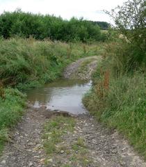
- Accessibility: The route is suitable for walkers and cyclists. Surfaces are predominantly unpaved and can be muddy in wet weather, so sturdy footwear is advised. Wheelchair accessibility is limited due to uneven terrain.
- Facilities: There are no restrooms or visitor centers on the path itself. Amenities are available at nearby Wandlebury Country Park and in Linton village.
Urban Legacy and Medieval Influence
Within Cambridge, the route of Via Devana is largely overlaid by modern streets such as St Andrew’s Street and Hills Road (Capturing Cambridge). While visible traces within the city are minimal, the street patterns and alignment of historic churches—as seen along King’s Parade and Bridge Street—reflect the road’s enduring influence on the urban landscape (Cambridge Historic Core Appraisal).
The road’s significance continued into the medieval era, when it was known by names such as Wolves Street and Woolstreet Way, testament to its role in the regional wool trade (FRRFD Roman Road Leaflet).
Points of Interest and Nearby Attractions
- Wandlebury Country Park: Home to Iron Age earthworks, woodland trails, panoramic views, café, and restrooms.
- Beechwoods Nature Reserve: Ancient woodland and chalk grassland habitats adjacent to the Roman Road.
- Fenstanton: Roman villa remains, rare archaeological finds, and a picturesque village setting (Newsweek).
- Cambridge Museums: The Fitzwilliam Museum and Museum of Archaeology and Anthropology offer Roman and medieval exhibits (The Sunrise Dreamers).
- Linton Village: A charming destination at the southeastern end of the route, perfect for refreshments after a walk or cycle.
Walking and Cycling the Route
Key Sections
- Worsted Street Roman Road: Best-preserved, runs from Worts’ Causeway to Linton, straight and scenic, suitable for both walkers and cyclists (Cambridge News).
- Urban Cambridge: Trace the historical alignment using a self-guided walking tour, connecting sites such as Castle Hill, Magdalene Bridge, and the Round Church (A Lady in London).
Access Points
- Wort’s Causeway (limited parking)
- Wandlebury Country Park (pay and display parking)
- Mount Farm and Worsted Lodge (near the A11)
Public transport is available from Cambridge to Haverhill, with stops at key access points (Cambridgeshire County Council).
Practical Visitor Information
- Best Time to Visit: Spring and summer offer ideal conditions, with wildflowers and pleasant weather.
- Recommended Itineraries:
- Half-day walk: Start at Worts’ Causeway, end in Linton (7 miles, 2.5–3.5 hours).
- Cycling route: 14-mile round trip, returning via quiet lanes.
- Safety: Stay on marked paths, respect the protected status of the monument, and supervise children.
Frequently Asked Questions (FAQs)
Is the Via Devana accessible year-round?
Yes, the route is open year-round with no entry fees.
Are guided tours available?
Yes, local history groups like FRRFD offer guided walks and events (FRRFD Roman Road Leaflet).
Are dogs allowed?
Dogs are welcome but must be kept under control, especially near wildlife and livestock.
Is there parking at the starting point?
Limited parking is available; public transport or cycling is encouraged.
Visual Resources and Maps
For navigation and historical context, consult Ordnance Survey Explorer maps 209 and 210. The FRRFD Roman Road Leaflet provides detailed route maps and information. Online resources such as RouteYou and Capturing Cambridge offer additional digital guides.
Essential Tips for Visitors
- Wear sturdy footwear; paths may be muddy.
- Bring water and snacks; facilities are limited.
- Download maps in advance due to patchy mobile signal.
- Respect archaeological sites and natural habitats.
- Check weather and trail conditions before setting out.
Further Resources
- Friends of the Roman Road and Fleam Dyke (FRRFD) Roman Road Leaflet
- Capturing Cambridge: Via Devana
- Cambridge News: Exploring Via Devana
- Trek Zone: Via Devana
- RouteYou: Walking routes in Via Devana
- A Lady in London: Cambridge Walking Tour
- Newsweek: Archaeological Discoveries at Fenstanton
Conclusion
Via Devana offers a direct connection to nearly two millennia of British history, linking the Roman, medieval, and modern narratives of Cambridge and its countryside. Whether walking, cycling, or joining a guided tour, visitors can immerse themselves in a landscape shaped by centuries of trade, engineering, and culture. With year-round free access and proximity to some of Cambridge’s finest museums and nature reserves, the Via Devana is an enriching destination for all ages and interests.
For the latest updates, tour information, and downloadable guides, explore the resources above or visit the Cambridge Tourist Information Centre. Enhance your journey with digital audio tours and events through the Audiala app. Begin your adventure along the Via Devana and experience the living legacy of Britain’s Roman past.
Sources
- Exploring Via Devana: Visiting Hours, Tickets, and Cambridge’s Ancient Roman Road, 2024 (Visit Cambridge)
- Exploring Via Devana in Cambridge: Visiting the Ancient Roman Road and Historical Sites, 2024 (Capturing Cambridge)
- Exploring Via Devana: Visiting Hours, Tickets, and Historical Sites in Cambridge, 2024 (Trek Zone)
- Exploring Via Devana Roman Road Near Cambridge: Visiting Hours, Routes & Tips, 2024 (Cambridge News)
- Friends of the Roman Road and Fleam Dyke (FRRFD) Roman Road Leaflet, 2021 (FRRFD)
