Diamer-Bhasha Dam: Visiting Hours, Tickets, and Comprehensive Travel Guide to Gilgit-Baltistan Historical Sites
Date: 14/06/2025
Introduction
The Diamer-Bhasha Dam, set amidst the awe-inspiring mountains of Gilgit-Baltistan in Pakistan, stands as a monumental symbol of modern engineering and a testament to the country’s vision for energy security, sustainable water management, and socio-economic growth. Located near Chilas on the Indus River, this dam—poised to be the tallest roller-compacted concrete (RCC) dam in the world at 272 meters—represents both progress and the complexities of preserving an ancient cultural landscape (Diamer Bhasha official; NS Energy).
This guide offers a detailed overview of the Diamer-Bhasha Dam, including its historical context, cultural significance, visitor logistics, travel tips, and key attractions in the Gilgit-Baltistan region.
Table of Contents
- Project History and Strategic Importance
- Political Milestones and Project Development
- Engineering Highlights and Environmental Impact
- Cultural Heritage and Archaeology
- Preservation Efforts
- Visitor Information (Hours, Tickets, Access)
- Travel Logistics and Practical Tips
- Key Nearby Attractions
- Frequently Asked Questions (FAQ)
- Summary and Visitor Recommendations
- Sources and Further Reading
Project History and Strategic Importance
The Diamer-Bhasha Dam was first conceptualized in the early 1980s to address Pakistan’s urgent need for additional water storage and clean energy. Its strategic location, about 315 km upstream from Tarbela Dam and 40 km downstream from Chilas, is ideal due to the Indus River’s high flow and the region’s suitable topography (The Nation).
The dam will significantly enhance Pakistan’s irrigation capacity, provide 4,500 MW of hydropower, and help mitigate seasonal floods, making it a linchpin in the nation’s Water Vision 2025 (Diamer Bhasha official; Bloom Pakistan).
Political Milestones and Project Development
Despite early feasibility studies, the project was delayed for decades due to funding constraints and regional disputes. The Pakistani government prioritized Diamer-Bhasha in 2006, and construction officially began in 2020 after securing local and international partnerships (Global Village Space). The dam is slated for completion by 2028–2029, with a total estimated cost exceeding Rs1,400 billion.
Engineering Highlights and Environmental Impact
The Diamer-Bhasha Dam, at completion, will be the world’s tallest RCC dam, with a gross storage capacity of 8.1 million acre-feet and the ability to irrigate 1.23 million acres of land (NS Energy). The twin powerhouses will deliver approximately 18 billion units of electricity annually, providing a critical boost to Pakistan’s energy grid.
However, the dam’s construction brings significant environmental and social impacts, including the displacement of more than 31,000 residents and the need for resettlement and compensation programs (The Nation). The region’s seismic activity also places demands on engineering safety standards and environmental management.
Cultural Heritage and Archaeology
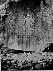
The Diamer-Bhasha Dam region is one of the richest archaeological sites in South Asia, home to more than 35,000 ancient rock carvings and petroglyphs dating back as far as 8,000 BCE (Dialogue Earth). These inscriptions and carvings, left by Silk Road travelers, merchants, and Buddhist pilgrims, offer invaluable insights into the area’s millennia-old history.
Preservation Efforts
To address the threat of submersion, WAPDA and cultural heritage organizations have initiated documentation, 3D scanning, and selective relocation of key artifacts. Plans include the establishment of a museum in Chilas, digital archives, and collaboration with international experts (Dialogue Earth).
Visitor Information
Visiting Hours and Tickets
- Construction Site Access: The dam itself remains an active construction zone and is not open to the public for direct access.
- Viewing Points: Designated public viewing areas near Chilas and along the Karakoram Highway are generally open from 9:00 AM to 5:00 PM.
- Tickets: No entry fee is required for public viewing areas. Guided tours or museum visits, once operational, may have nominal charges (Gypsy Tours; Gilgit-Baltistan Tourism Department).
Guided Tours
Guided tours to the dam’s periphery and nearby heritage sites can be arranged through local tour operators or with advance permission from WAPDA. These tours provide insight into the dam’s engineering, environmental initiatives, and local culture.
Accessibility
- By Road: The main access is via the Karakoram Highway, connecting Islamabad to Chilas (approx. 10–12 hours by car or bus, depending on road conditions).
- By Air: The nearest airport is in Gilgit; from there, it’s a 3–4 hour drive to Chilas.
- Local Transport: Jeeps and taxis operate in the region, but terrain can be rugged.
- Permits: Foreigners may require special permits or registration; check with authorities before travel.
Accommodation
Chilas offers several hotels and guesthouses, including Shangrila Resort, Akbar Tourist Inn, Grace Continental Hotel, and others. Booking in advance is recommended, especially in summer (Gilgit Baltistan Discoveries).
Key Nearby Attractions
Rock Carvings and Petroglyphs
The banks of the Indus near Chilas are dotted with ancient rock art and inscriptions, some of which can be visited on guided tours. Many are being digitized and relocated to prevent loss from the rising dam reservoir (Earth Journalism; Travel Pakistani).
Fairy Meadows & Nanga Parbat
A short journey from Chilas brings you to Fairy Meadows, one of Pakistan’s most scenic alpine meadows, with dramatic views of Nanga Parbat, the world’s ninth-highest peak (Zameen.com).
Gilgit and Hunza Valleys
Travelers can extend their journey to explore the cultural and natural wonders of Gilgit and Hunza, including ancient forts, vibrant bazaars, and spectacular mountain scenery.
Karakoram Highway
The KKH itself is a world-renowned road trip, offering breathtaking views, access to remote valleys, and a unique experience of Pakistan’s mountainous north.
Travel Logistics and Practical Tips
- Best Time to Visit: May–October offers the most favorable weather and open roads.
- Health & Safety: Prepare for high altitude, rapidly changing weather, and limited medical facilities.
- Cash & Connectivity: Carry sufficient cash; ATMs and internet are limited outside major towns.
- Road Safety: Travel during daylight and consider hiring experienced drivers.
- Cultural Sensitivity: Dress modestly, ask permission before photographing locals, and respect local customs (Visit Gilgit Baltistan).
- Permits & Security: Stay informed of local regulations, protests, or security advisories, especially given ongoing resettlement and social tensions (Arab News; The News).
Frequently Asked Questions (FAQ)
Q: What are the public visiting hours for Diamer-Bhasha Dam?
A: Public viewing points are open from 9:00 AM to 5:00 PM, but hours may vary depending on construction and security.
Q: Do I need a ticket to visit the dam?
A: No tickets are required for public viewing areas at this time. Entry to construction zones is restricted.
Q: Can I arrange a guided tour?
A: Yes, through local operators or with WAPDA’s advance permission.
Q: Are there nearby historical sites?
A: The area is rich in ancient rock carvings, as well as other historic and natural sites in Gilgit-Baltistan.
Q: When is the best time to visit?
A: May–October, when weather and road conditions are optimal.
Summary and Visitor Recommendations
The Diamer-Bhasha Dam serves as both a beacon of Pakistan’s progress and a custodian of ancient heritage. Visitors can witness this transformation by exploring the dam’s periphery, engaging with local communities, and appreciating the region’s unique blend of engineering prowess and cultural depth. Thoughtful planning, respect for local customs, and support for sustainable tourism are key to a rewarding visit.
For the latest updates, download the Audiala app and consult official resources. Embrace the opportunity to experience a living crossroads of history and development in one of the world’s most dramatic landscapes.
Sources and Further Reading
- Diamer-Bhasha Dam: History, Significance, Visitor Guide, and Cultural Heritage (Diamer Bhasha official)
- Diamer-Bhasha Dam: A Historic Milestone (The Nation)
- Diamer-Bhasha Dam to Transform Pakistan’s Fortune (Global Village Space)
- Diamer-Bhasha Dam Under Construction Details (NS Energy)
- Diamer-Bhasha Dam Visitor Guide (Gilgit-Baltistan Tourism Department)
- Diamer-Bhasha Dam Will Drown Ancient Carvings (Dialogue Earth)
- Construction Work Underway on 17 Key Sites (The Nation)
- Diamer-Bhasha Dam Sight and Tours (Gypsy Tours)
- Gilgit-Baltistan Environmental Impact Assessment Report (Gilgit-Baltistan EPA)
- Traveler Trails (Traveler Trails)
- Gilgit Baltistan Discoveries (Gilgit Baltistan Discoveries)
- Visit Gilgit Baltistan (Visit Gilgit Baltistan)
- Earth Journalism (Earth Journalism)
- Travel Pakistani (Travel Pakistani)
- Arab News (Arab News)
- The News (The News)
- Zameen.com (Zameen.com)


