कलारकुट्टी बांध: केरल, भारत की यात्रा के लिए एक व्यापक मार्गदर्शिका
दिनांक: 04/07/2025
परिचय
केरल के इडुक्की जिले के हरे-भरे पश्चिमी घाटों के बीच स्थित, कलारकुट्टी बांध केरल की टिकाऊ जल प्रबंधन, पनबिजली उत्पादन और क्षेत्रीय विकास की प्रतिबद्धता का एक प्रमाण है। मुथिरपुझा नदी पर बना यह बांध, जो पेरियार की एक प्रमुख सहायक नदी है, नेरियामंगलम पनबिजली परियोजना का एक अभिन्न अंग है। इंजीनियर ई.यू. फिलिपोस के मार्गदर्शन में 1961 में शुरू किया गया, कलारकुट्टी बांध न केवल ऊर्जा उत्पादन और सिंचाई का समर्थन करता है, बल्कि यह पर्यटकों के लिए एक शांत गंतव्य भी बन गया है जो प्राकृतिक सुंदरता और ऐतिहासिक अंतर्दृष्टि की तलाश में हैं (विकिपीडिया; केरल पर्यटन; ट्रिपहोबो)।
यह मार्गदर्शिका बांध के ऐतिहासिक, पर्यावरणीय और सांस्कृतिक महत्व की खोज करते हुए, आगंतुक घंटों, टिकटिंग, पहुंच और यात्रा युक्तियों पर व्यावहारिक विवरण प्रदान करती है। चाहे आप एक छोटी यात्रा की योजना बना रहे हों या इडुक्की की पनबिजली विरासत की गहरी खोज कर रहे हों, यह संसाधन आपको कलारकुट्टी बांध का सर्वोत्तम अनुभव लेने के लिए सुसज्जित करता है।
विषय-सूची
- प्रारंभिक संकल्पना और सामरिक महत्व
- निर्माण समयरेखा और इंजीनियरिंग
- पनबिजली उत्पादन और क्षेत्रीय प्रभाव
- आगंतुक घंटे, टिकट और सुविधाएं
- कलारकुट्टी बांध कैसे पहुंचें
- गतिविधियाँ और आस-पास के आकर्षण
- पर्यावरणीय और सामाजिक-आर्थिक संदर्भ
- सुरक्षा, पहुंच और जिम्मेदार पर्यटन
- अक्सर पूछे जाने वाले प्रश्न (एफएक्यू)
- अंतिम सुझाव और निष्कर्ष
प्रारंभिक संकल्पना और सामरिक महत्व
कलारकुट्टी बांध को 1950 के दशक में पश्चिमी घाटों की जलविद्युत क्षमता का उपयोग करने के केरल के महत्वाकांक्षी अभियान के हिस्से के रूप में तैयार किया गया था। इडुक्की के वेल्लाठूवल पंचायत में रणनीतिक रूप से स्थित, बांध के स्थान को इसके बारहमासी जल प्रवाह और मध्य केरल के बढ़ते जनसंख्या केंद्रों से निकटता के लिए चुना गया था। परियोजना ने बिजली, सिंचाई और बाढ़ नियंत्रण की बढ़ती मांगों को पूरा किया, जिससे केरल के स्वतंत्रता-पश्चात आधुनिकीकरण में एक महत्वपूर्ण संपत्ति बन गई (विकिपीडिया; डीबीपीडिया)।
निर्माण समयरेखा और इंजीनियरिंग
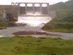
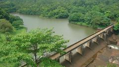
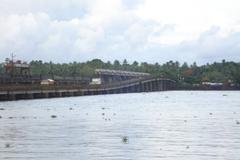
निर्माण 1950 के दशक के अंत में शुरू हुआ, और 1961 में बांध के चालू होने के साथ समाप्त हुआ। कलारकुट्टी एक कंक्रीट गुरुत्वाकर्षण बांध है - 183 मीटर लंबा और 43 मीटर ऊंचा - जिसमें 0.648 वर्ग किमी का जलाशय सतह क्षेत्र और 6.88 मिलियन क्यूबिक मीटर की भंडारण क्षमता है। डिजाइन और निर्माण ने क्षेत्र की खड़ी भू-आकृतियों और मानसून की जलवायु द्वारा प्रस्तुत महत्वपूर्ण चुनौतियों को पार किया (विकिपीडिया; बिनिल.ओआरजी)।
पनबिजली उत्पादन और क्षेत्रीय प्रभाव
बांध नेरियामंगलम पनबिजली परियोजना के केंद्र में है। मुथिरपुझा नदी से पानी को टर्बाइनों से लैस एक पावरहाउस में मोड़ा जाता है (मूल रूप से कुल 45 मेगावाट, 2006 में 52.65 मेगावाट तक अपग्रेड किया गया) (विकिपीडिया; डीबीपीडिया)। यह परियोजना कई तालुकों में बिजली की जरूरतों का समर्थन करती है और चाय, इलायची और मसालों के बागानों के लिए कृषि सिंचाई को बनाए रखती है, जो क्षेत्रीय अर्थव्यवस्था के लिए महत्वपूर्ण हैं। नियंत्रित जल निकासी मानसून की बाढ़ को कम करने में मदद करती है और शुष्क मौसम के दौरान घरेलू पानी की आपूर्ति करती है (वनइंडिया; इडुक्की जिला आधिकारिक साइट)।
आगंतुक घंटे, टिकट और सुविधाएं
- आगंतुक घंटे: आम तौर पर प्रतिदिन सुबह 9:00 बजे से शाम 5:00 बजे तक खुला रहता है, हालांकि रखरखाव या मौसमी कारकों के कारण कार्यक्रम भिन्न हो सकते हैं। यात्रा करने से पहले स्थानीय अधिकारियों या केएसईबी से पुष्टि करें।
- प्रवेश शुल्क: आमतौर पर कोई प्रवेश शुल्क नहीं होता है; हालांकि, नौका विहार या विशेष गतिविधियों के लिए एक मामूली शुल्क लग सकता है।
- सुविधाएं: पार्किंग, बेंच, शौचालय और छायांकित क्षेत्रों जैसी बुनियादी सुविधाएं उपलब्ध हैं। ऊबड़-खाबड़ इलाकों के कारण सीमित गतिशीलता वाले आगंतुकों के लिए पहुंच सीमित हो सकती है।
कलारकुट्टी बांध कैसे पहुंचें
- सड़क मार्ग से: बांध मुन्नार से लगभग 18-20 किमी (लगभग 30-40 मिनट कार द्वारा) और अदियाली जैसे कस्बों से 25-40 किमी दूर है। सड़कें सुंदर लेकिन घुमावदार हैं।
- रेल/हवाई मार्ग से: निकटतम रेलवे स्टेशन अलुवा (लगभग 100 किमी दूर) है, और सबसे निकटतम हवाई अड्डा कोचीन अंतर्राष्ट्रीय हवाई अड्डा है।
- परिवहन विकल्प: निजी टैक्सियों की सिफारिश की जाती है; सार्वजनिक परिवहन सीमित है।
- गूगल मैप्स स्थान
गतिविधियाँ और आस-पास के आकर्षण
बांध के नज़ारे और प्रकृति की सैर
निर्दिष्ट रास्ते और नज़ारे जलाशय और आसपास की पहाड़ियों के मनोरम दृश्य प्रस्तुत करते हैं - फोटोग्राफी के लिए एकदम सही, खासकर सूर्योदय और सूर्यास्त के समय।
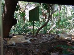
पक्षी अवलोकन और नौका विहार
यह क्षेत्र देशी पक्षी जीवन के लिए एक आश्रय स्थल है, विशेष रूप से अक्टूबर और फरवरी के बीच (केरल पक्षी हॉटस्पॉट)। नौका विहार कभी-कभी पर्यटन मौसम के दौरान उपलब्ध होता है, जो जल स्तर और केएसईबी की मंजूरी के अधीन है।
पिकनिक और विश्राम
बांध के पास छायादार क्षेत्र और उद्यान पिकनिक के लिए शांत स्थान प्रदान करते हैं। भोजन के स्टाल सीमित होने के कारण अपना नाश्ता लाएं।
आस-पास के आकर्षण
- इडुक्की आर्क बांध: एक प्रसिद्ध इंजीनियरिंग चमत्कार।
- एराविकुलम राष्ट्रीय उद्यान: वन्यजीवों और लुढ़कती पहाड़ियों के लिए जाना जाता है।
- मुन्नार हिल स्टेशन: चाय बागानों और सुखद जलवायु के लिए प्रसिद्ध।
- नेरियामंगलम झरने: सुंदर और सुलभ।
पर्यावरणीय और सामाजिक-आर्थिक संदर्भ
कलारकुट्टी बांध पारिस्थितिक रूप से संवेदनशील पश्चिमी घाटों के भीतर स्थित है, जो एक यूनेस्को विश्व धरोहर स्थल है। इसका जलाशय स्थानीय जैव विविधता का समर्थन करता है, लेकिन इसने प्राकृतिक नदी प्रवाह को भी बदल दिया है। संरक्षण लक्ष्यों के साथ बिजली उत्पादन को संतुलित करने के लिए निरंतर प्रयास चल रहे हैं (केरल पर्यटन)। बांध का जल प्रबंधन खेती समुदायों का समर्थन करता है और इडुक्की के सामाजिक-आर्थिक विकास में योगदान देता है, प्रत्यक्ष और अप्रत्यक्ष रोजगार प्रदान करता है और स्थानीय उद्योगों का समर्थन करता है (एशिया हाइलाइट्स)।
सुरक्षा, पहुंच और जिम्मेदार पर्यटन
- सुरक्षा: परिचालन क्षेत्रों तक पहुंच प्रतिबंधित है; हमेशा पोस्ट किए गए दिशानिर्देशों का पालन करें।
- पहुंच: इलाका मध्यम रूप से पहाड़ी है और पूरी तरह से व्हीलचेयर से सुलभ नहीं है।
- जिम्मेदार पर्यटन: कचरे का ठीक से निपटान करें, शोर कम करें, और स्थानीय रीति-रिवाजों का सम्मान करें। सामुदायिक-आधारित पर्यटन पहलों में भाग लेना स्थानीय अर्थव्यवस्था का समर्थन करने में मदद करता है (आईजेएसआर)।
रखरखाव अद्यतन और पर्यावरण प्रबंधन
हालिया मरम्मत: 2024 के अंत और 2025 की शुरुआत में, स्लुइस वाल्व प्रतिस्थापन और गाद निकालने सहित तत्काल मरम्मत ने अस्थायी रूप से बांध को आगंतुकों के लिए बंद कर दिया और जलाशय के स्वरूप को प्रभावित किया (द हिंदू)। गाद भरने से क्षमता लगभग आधी रह गई है, जिससे चल रहे पुनर्स्थापन के प्रयास किए गए हैं (द हिंदू)। अपनी यात्रा की योजना बनाने से पहले हमेशा रखरखाव संबंधी बंदों की जांच करें।
बाढ़ का खतरा: मानसून के दौरान, ओवरफ्लो को रोकने के लिए शटर खोले जा सकते हैं। स्थानीय सलाह की निगरानी करें और उच्च-रिलीज अवधियों के दौरान नदी के किनारों से बचें (ओमनोरमा)।
अक्सर पूछे जाने वाले प्रश्न (एफएक्यू)
प्रश्न: कलारकुट्टी बांध के आगंतुक घंटे क्या हैं? ए: आम तौर पर सुबह 9:00 बजे से शाम 5:00 बजे तक। यात्रा करने से पहले स्थानीय पर्यटन कार्यालयों से पुष्टि करें।
प्रश्न: क्या कोई प्रवेश शुल्क है? ए: नहीं, लेकिन नौका विहार या विशेष गतिविधियों के लिए टिकट की आवश्यकता हो सकती है।
प्रश्न: मुन्नार से कलारकुट्टी बांध कैसे पहुंचें? ए: कार से लगभग 18 किमी; निजी टैक्सियों की सिफारिश की जाती है।
प्रश्न: क्या निर्देशित पर्यटन उपलब्ध हैं? ए: नियमित रूप से नहीं, लेकिन स्थानीय गाइड या केरल पर्यटन पीक सीजन के दौरान पर्यटन की पेशकश कर सकते हैं।
प्रश्न: क्या बांध व्हीलचेयर से सुलभ है? ए: कुछ क्षेत्र ऊबड़-खाबड़ इलाकों के कारण सुलभ नहीं हैं।
प्रश्न: क्या मछली पकड़ना और नौका विहार की अनुमति है? ए: नौका विहार कभी-कभी उपलब्ध होता है; मछली पकड़ना आम तौर पर विनियमित घटनाओं को छोड़कर निषिद्ध है।
एक यादगार यात्रा के लिए अंतिम सुझाव
- यात्रा का सबसे अच्छा समय: ठंडे, साफ मौसम के लिए दिसंबर से फरवरी; हरे-भरे परिदृश्यों के लिए मानसून के बाद के महीने (अक्टूबर-नवंबर)।
- पोशाक: शालीनता से कपड़े पहनें और आरामदायक जूते पहनें।
- आवश्यक वस्तुएं: पानी, नाश्ता और कैमरा साथ ले जाएं। सुविधाएं बुनियादी हैं।
- गंतव्य मिलाएं: अधिक समृद्ध अनुभव के लिए इडुक्की आर्क बांध, एराविकुलम राष्ट्रीय उद्यान या मुन्नार के साथ अपनी यात्रा को जोड़ें।
निष्कर्ष
कलारकुट्टी बांध केरल की इंजीनियरिंग उपलब्धि, टिकाऊ विकास और प्राकृतिक सुंदरता का प्रतीक है। क्षेत्र को शक्ति प्रदान करने, कृषि का समर्थन करने और बाढ़ को नियंत्रित करने में इसकी भूमिका शांत दर्शनीय स्थलों और पर्यावरण-अनुकूल पर्यटन के लिए एक शांत गंतव्य के रूप में इसकी अपील से मेल खाती है। आगे योजना बनाकर और जिम्मेदार यात्रा का अभ्यास करके, आगंतुक बांध के ऐतिहासिक और पारिस्थितिक मूल्य की पूरी तरह से सराहना कर सकते हैं, साथ ही उन समुदायों का समर्थन कर सकते हैं जो इस उल्लेखनीय स्थल की देखभाल करते हैं (केरल राज्य विद्युत बोर्ड; वनइंडिया; द हिंदू)।
व्यक्तिगत यात्रा योजना, वास्तविक समय अद्यतन और विशेष अंतर्दृष्टि के लिए, ऑडियाला ऐप डाउनलोड करें और अधिक जानकारी के लिए हमें सोशल मीडिया पर फॉलो करें।
संदर्भ और आगे पढ़ना
- कलारकुट्टी बांध — विकिपीडिया
- केरल पर्यटन — कलारकुट्टी बांध
- ट्रिपहोबो — कलारकुट्टी बांध गाइड
- वनइंडिया — कलारकुट्टी बांध जल स्तर अद्यतन
- द हिंदू — कलारकुट्टी बांध रखरखाव समाचार
- केरल राज्य विद्युत बोर्ड (KSEB)
- डीबीपीडिया — कलारकुट्टी बांध
- बिनिल.ओआरजी — कलारकुट्टी बांध
- इडुक्की जिला आधिकारिक साइट
- एशिया हाइलाइट्स — केरल यात्रा
- केरल पक्षी हॉटस्पॉट
- आईजेएसआर — केरल में सामुदायिक-आधारित पर्यटन
- ओमनोरमा — केरल बांध रिलीज
- मनोरमा ऑनलाइन — कलारकुट्टी बांध भूमि अधिकार विरोध
ऑडियला2024- Comprehensive Coverage: Address common questions and topics of interest such as the history of the monument, its cultural significance, visitor information (e.g., ticket prices, opening hours), travel tips, nearby attractions, and accessibility. Include sections that might be unique to the monument, like special events, guided tours, and photographic spots.
- Quality Content: Ensure the content is well-researched, accurate, and provides real value to readers. Use reliable sources and provide factual information. Write in a clear, engaging, and accessible style. Consider your audience and use language that is appropriate for those likely to visit the monument.
- Visuals and Media: Incorporate high-quality images or videos of the monument. These should be optimized for the web (correct sizing, alt tags with keywords). Consider interactive elements like virtual tours or maps.
- Internal and External Links: Include links to other related articles on your site to encourage deeper engagement (internal links). Link to official websites for the monument or credible sources for further reading (external links).
- FAQ: Incorporate FAQ sections to target voice search queries and featured snippets
- Visit and Stay Up to Date: End the article with a call to action, such as encouraging readers to download our mobile app Audiala, check out other related posts, or follow on social media for more updates.’], ‘max_sections’: 4, ‘publish_formats’: {‘pdf’: False, ‘docx’: False, ‘markdown’: True}, ‘follow_guidelines’: True}, ‘title’: ‘A Comprehensive Guide to Visiting Kallarkutty Dam, Kerala, India’, ‘report’: ’# Kallarkutty Dam Visiting Hours, Tickets, and Travel Guide\n\n#### Date: 04/07/2025\n\n---\n\n## Introduction\n\nNestled amid the lush Western Ghats in Kerala’s Idukki district, Kallarkutty Dam is a testament to Kerala’s commitment to sustainable water management, hydroelectric power generation, and regional development. Built across the Muthirapuzha River, a key tributary of the Periyar, the dam forms an integral part of the Neriamangalam Hydroelectric Project. Commissioned in 1961 under the guidance of engineer E.U. Philipose, Kallarkutty Dam not only supports energy production and irrigation but has also become a tranquil destination for tourists seeking natural beauty and historical insight (Wikipedia; Kerala Tourism; Triphobo).\n\nThis guide provides practical details on visiting hours, ticketing, accessibility, and travel tips, while also exploring the dam’s historical, environmental, and cultural significance. Whether you’re planning a short visit or a deeper exploration of Idukki’s hydroelectric heritage, this resource equips you to experience Kallarkutty Dam at its best.\n\n---\n\n## Table of Contents\n\n- Early Conception and Strategic Importance\n- Construction Timeline and Engineering\n- Hydroelectric Power and Regional Impact\n- Visiting Hours, Tickets, and Facilities\n- How to Reach Kallarkutty Dam\n- Activities and Nearby Attractions\n- Environmental and Socio-Economic Context\n- Safety, Accessibility, and Responsible Tourism\n- Frequently Asked Questions (FAQs)\n- Final Tips and Conclusion\n\n---\n\n## Early Conception and Strategic Importance\n\nKallarkutty Dam was conceived in the 1950s as part of Kerala’s ambitious drive to harness the hydropower of the Western Ghats. Strategically situated in the Vellathooval panchayat of Idukki, the dam’s location was chosen for its perennial water flow and proximity to growing population centers in central Kerala. The project addressed increasing demands for electricity, irrigation, and flood control, becoming a pivotal asset in Kerala’s post-independence modernization (Wikipedia; DBpedia).\n\n---\n\n## Construction Timeline and Engineering\n\nConstruction began in the late 1950s, culminating with the dam’s commissioning in 1961. Kallarkutty is a concrete gravity dam—183 meters long and 43 meters high—with a reservoir surface area of 0.648 sq km and a storage capacity of 6.88 million cubic meters. The design and construction overcame significant challenges posed by the region’s steep terrain and monsoon climate (Wikipedia; Binil.org).\n\n---\n\n## Hydroelectric Power and Regional Impact\n\nThe dam is central to the Neriamangalam Hydroelectric Project. Water is diverted from the Muthirapuzha River to a powerhouse equipped with turbines (originally totaling 45 MW, upgraded to 52.65 MW in 2006) (Wikipedia; DBpedia). The project supports electricity needs across several taluks and sustains agricultural irrigation for tea, cardamom, and spice plantations, which are vital to the regional economy. Controlled water releases help mitigate monsoon flooding and supply domestic water during dry seasons (OneIndia; Idukki District Official Site).\n\n---\n\n## Visiting Hours, Tickets, and Facilities\n\n- Visiting Hours: Typically open from 9:00 AM to 5:00 PM daily, though schedules may vary due to maintenance or seasonal factors. Confirm with local authorities or KSEB before visiting.\n- Entry Fee: There is generally no entry fee; however, boating or special activities may incur a nominal charge.\n- Facilities: Basic amenities such as parking, benches, restrooms, and shaded areas are available. Accessibility may be limited for visitors with mobility challenges due to uneven terrain.\n\n---\n\n## How to Reach Kallarkutty Dam\n\n- By Road: The dam is about 18–20 km from Munnar (approximately 30–40 minutes by car) and 25–40 km from towns like Adimali. Roads are scenic but winding.\n- By Rail/Air: The nearest railway station is Aluva (about 100 km away), and the closest airport is Cochin International Airport.\n- Transport Options: Private taxis are recommended; public transport is limited.\n- Google Maps Location\n\n---\n\n## Activities and Nearby Attractions\n\n### Dam Viewpoints and Nature Walks\n\nDesignated pathways and viewpoints offer panoramic vistas of the reservoir and surrounding hills—perfect for photography, especially at sunrise and sunset.\n\n### Birdwatching and Boating\n\nThe area is a haven for endemic birdlife, especially between October and February (Kerala Birding Hotspots). Boating is occasionally available during tourist seasons, subject to water levels and KSEB approval.\n\n### Picnicking and Relaxation\n\nShaded areas and gardens near the dam provide tranquil spots for picnics. Bring your own snacks as food stalls are limited.\n\n### Nearby Attractions\n\n- Idukki Arch Dam: A renowned engineering marvel.\n- Eravikulam National Park: Known for its wildlife and rolling hills.\n- Munnar Hill Station: Famous for tea plantations and pleasant climate.\n- Neriamangalam Waterfalls: Scenic and accessible.\n\n---\n\n## Environmental and Socio-Economic Context\n\nKallarkutty Dam is located within the ecologically sensitive Western Ghats, a UNESCO World Heritage site. Its reservoir supports local biodiversity, but has also altered natural river flows. Continued efforts are underway to balance power generation with conservation goals (Kerala Tourism). The dam’s water management supports farming communities and contributes to the socio-economic development of Idukki, providing direct and indirect employment and supporting local industries (Asia Highlights).\n\n---\n\n## Safety, Accessibility, and Responsible Tourism\n\n- Safety: Restricted access to operational areas; always observe posted guidelines.\n- Accessibility: Terrain is moderately hilly and not fully wheelchair accessible.\n- Responsible Tourism: Dispose of litter properly, minimize noise, and respect local customs. Participating in community-based tourism initiatives helps support the local economy (IJSR).\n\n---\n\n## Maintenance Updates and Environmental Management\n\nRecent Repairs: In late 2024 and early 2025, urgent repairs—including sluice valve replacement and desiltation—temporarily closed the dam to visitors and affected the reservoir’s appearance (The Hindu). Siltation has reduced capacity by nearly half, prompting ongoing restoration efforts (The Hindu). Always check for maintenance-related closures before planning your visit.\n\nFlood Risks: During monsoon, shutters may be opened to prevent overflow. Monitor local advisories and avoid riverbanks during high-release periods (Onmanorama).\n\n---\n\n## Frequently Asked Questions (FAQs)\n\nQ: What are the Kallarkutty Dam visiting hours? \nA: Generally 9:00 AM to 5:00 PM. Confirm with local tourism offices before visiting.\n\nQ: Is there an entry fee? \nA: No, but boating or special activities may require a ticket.\n\nQ: How do I reach Kallarkutty Dam from Munnar? \nA: About 18 km by car; private taxis are recommended.\n\nQ: Are there guided tours? \nA: Not routinely, but local guides or Kerala Tourism may offer tours during peak seasons.\n\nQ: Is the dam wheelchair accessible? \nA: Some areas are not accessible due to uneven terrain.\n\nQ: Are fishing and boating allowed? \nA: Boating is occasionally available; fishing is generally prohibited except during regulated events.\n\n---\n\n## Final Tips for a Memorable Visit\n\n- Best Time to Visit: December to February for cool, clear weather; post-monsoon months (October–November) for lush landscapes.\n- Clothing: Dress modestly and wear comfortable shoes.\n- Essentials: Carry water, snacks, and a camera. Facilities are basic.\n- Combine Destinations: Pair your trip with Munnar, Idukki Arch Dam, or Eravikulam National Park for a richer experience.\n\n---\n\n## Conclusion\n\nKallarkutty Dam stands as a symbol of Kerala’s engineering achievement, sustainable development, and natural splendor. Its role in powering the region, supporting agriculture, and controlling floods is matched by its appeal as a destination for tranquil sightseeing and eco-friendly tourism. By planning ahead and practicing responsible travel, visitors can fully appreciate the dam’s historical and ecological value while supporting the communities that care for this remarkable landmark (Kerala State Electricity Board; OneIndia; The Hindu).\n\n---\n\nFor personalized travel planning, real-time updates, and exclusive insights, download the Audiala app and follow us on social media.\n\n---\n\n## References and Further Reading\n\n- Kallarkutty Dam — Wikipedia\n- Kerala Tourism — Kallarkutty Dam\n- Triphobo — Kallarkutty Dam Guide\n- OneIndia — Kallarkutty Dam Water Level Updates\n- The Hindu — Kallarkutty Dam Maintenance News\n- Kerala State Electricity Board (KSEB)\n- DBpedia — Kallarkutty Dam\n- Binil.org — Kallarkutty Dam\n- Idukki District Official Site\n- Asia Highlights — Kerala Travel\n- Kerala Birding Hotspots\n- IJSR — Community-Based Tourism in Kerala\n- Onmanorama — Kerala Dam Releases\n- Manorama Online — Kallarkutty Dam Land Rights Protest\n\n---\n\n