
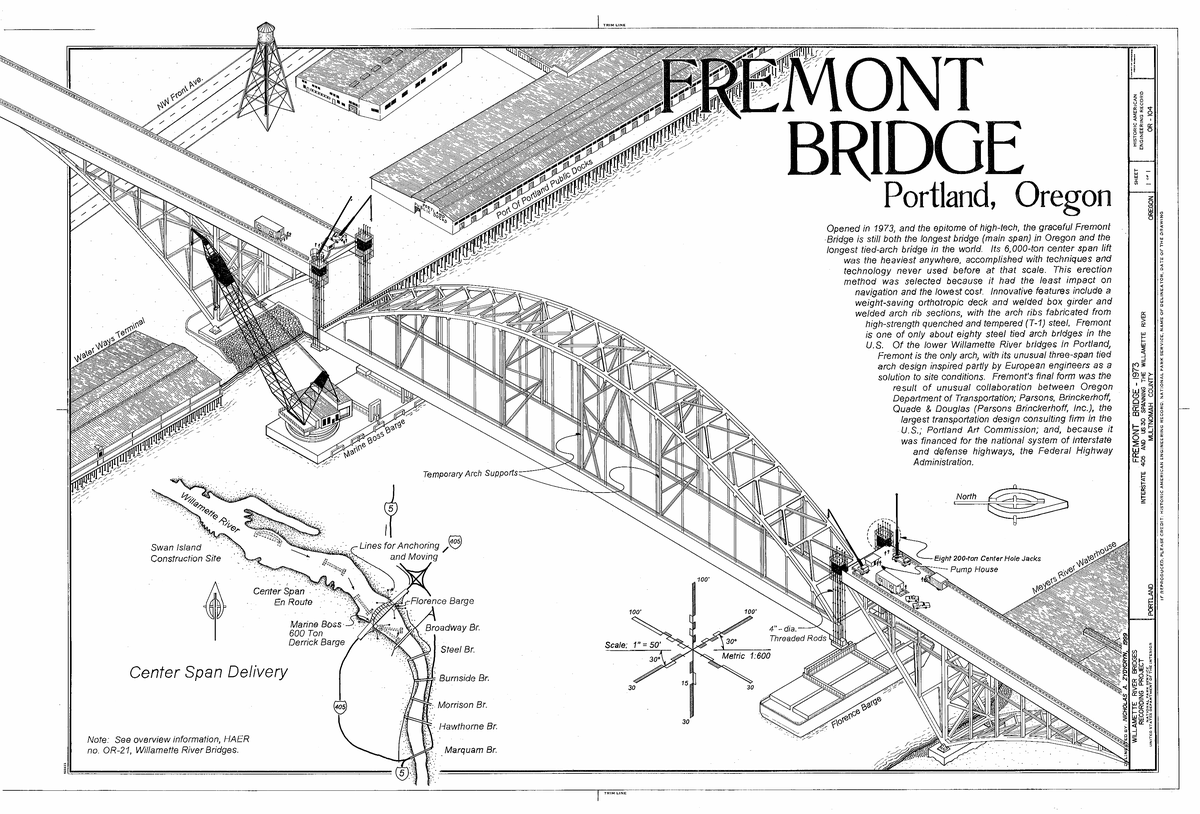
What the Fremont Bridge is
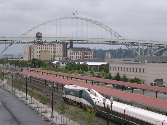
The Fremont Bridge is a double-deck tied-arch bridge spanning the Willamette River in Portland, Oregon. Completed in 1973, it carries Interstate 405 and U.S. Route 30 and connects North and Northwest Portland. It is a major part of the city’s transportation network and a defining feature of Portland’s skyline (Oregon Hikers Field Guide, Wikipedia).
The bridge’s main span is 1,255 feet (382 meters), and its total length is approximately 2,154 feet (657 meters). It is described as Oregon’s longest main span and the world’s second-longest tied-arch bridge as of 2025 (Travel Portland). At completion, it held the record for the world’s longest tied-arch span (Historic Bridges). Another account describes it as the second-longest tied-arch bridge in the world at the time, with a 1,255-foot main span (Bridge of the Week).
The bridge carries eight lanes: four upper-deck lanes for westbound US 30 and southbound I-405, and four lower-deck lanes for eastbound US 30 and northbound I-405 (Wikipedia). It carries over 120,000 vehicles daily (Visitor Oregon); another account gives an average daily traffic volume exceeding 120,000 vehicles.
History and significance
Origins, design, and construction
The bridge was conceived in the late 1960s as Portland expanded and needed better transportation links between downtown and North Portland. It is named after Fremont Street, its intended eastside approach; the street honors John C. Frémont, the 19th-century explorer and surveyor of the Oregon Trail (Oregon Hikers Field Guide). It is also described as being named after John C. Frémont.
Following criticism of the utilitarian Marquam Bridge, the Oregon Department of Transportation (ODOT) worked with the Portland Art Commission to create a bridge that combined function with visual appeal (Light the Bridges). Parsons, Brinckerhoff, Quade and Douglas designed it, and Murphy Pacific Corporation constructed it, with contributions from the Portland Art Commission and private engineering firms (Wikipedia; Library of Congress).
Construction began in the late 1960s, and the bridge opened in November 1973. The project cost $82 million ([Wikipedia](https://en.wikipedia.org/wiki/Fremont_Bridge_(Portland,_Oregon); Oregon Hikers Field Guide). The main arch, 902 feet long and weighing 6,000 tons, was assembled offsite, floated into position, and lifted 175 feet above the river by hydraulic jacks in a record-setting 50-hour operation (Light the Bridges). Periodic maintenance, including a significant renovation in 2016, supports the bridge’s safety and longevity (Oregon Essential).
Urban and community history
The bridge was part of a larger vision for Portland’s freeway system, influenced by urban planner Robert Moses’s 1943 blueprint (ArchDaily). Its construction took place during the national “Freeway Revolt,” a grassroots movement opposing the destruction of urban neighborhoods. The cancellation of several proposed freeways and the removal of Harbor Drive in favor of Tom McCall Waterfront Park reflected a shift toward people-centered public spaces (ArchDaily).
Construction of the bridge and its I-405 ramps displaced residents and businesses in Albina, a historically Black neighborhood. Hundreds of homes and businesses were demolished during urban renewal in the 1960s and 1970s, contributing to lasting social and economic effects and neighborhood fragmentation (Portland Mercury). Community-led initiatives have advocated for redesigning or removing some ramps to reconnect neighborhoods and reclaim land for local use. Current planning discussions also focus on alternatives for the “overbuilt” I-405 ramps, walkability, and urban equity (Portland Mercury).
The bridge has become a visual emblem of Portland’s engineering and creative identity, and it appears in local art, photography, and media. Its history also remains connected to discussions of community impact, restorative justice, and environmental justice.
The river and environmental context
The Fremont Bridge spans the Lower Willamette River near the Portland Harbor Superfund Site, an area contaminated by heavy metals, PCBs, and other pollutants. The bridge itself is not identified as a contamination source, but its setting reflects the relationship between urban infrastructure and river health (Oregon Health Authority).
The Oregon Health Authority, EPA, and DEQ coordinate environmental monitoring. The primary health concern is eating resident fish that may accumulate toxins; swimming and boating are generally considered safe. Visitors should follow posted warnings, especially those concerning fish consumption and areas such as the former GASCO site and Willamette Cove (Oregon Health Authority). Remediation of the Portland Harbor Superfund Site and neighborhood-reconnection efforts are also linked to equitable access to clean environments and public spaces (Portland Mercury).
What to see
Architecture and views
The bridge’s steel tied-arch has a distinctive rainbow-like shape, rises 381 feet above the water, and is adorned with American flags (Light the Bridges). Its upper deck uses a steel-plate orthotropic design, while the concrete lower deck is suspended from above (Light the Bridges). The striking white arch is a recognizable part of the city skyline.
The bridge can be viewed from parks, trails, and other vantage points along the river. Suggested spots include:
- Riverplace Park
- Cathedral Park
- Eastbank Esplanade
- Overlook Park
- NW Westover Road
- Willamette Greenway Trail
- Fields Park
- Tom McCall Waterfront Park
- Council Crest
- Rocky Butte
Overlook Park and the Eastbank Esplanade provide green space, opportunities to observe wildlife, and views of the bridge (Oregon Essential). Some vantage points frame the bridge with the Portland skyline and Mount Adams or Mount Hood in the background (Oregon Essential). The bridge is also visible from locations along the Willamette River and helps orient visitors around the city (Local Adventurer).
Events and activities
The annual Providence Bridge Pedal gives participants a rare chance to cross the Fremont Bridge’s upper deck on foot or by bike. Portland’s Rose Festival takes place from late May to early June; although the bridge is not a central venue, it can be a scenic backdrop for festival activity viewed from nearby riverfront parks.
Other events around the city include Pedalpalooza, a three-month cycling celebration with rides that sometimes feature the Fremont Bridge as a scenic waypoint, and the annual World Naked Bike Ride, which occasionally routes near the bridge. River cruises and kayak rentals offer views from the water, including beneath the bridge (Travel Portland - Outdoor Adventures).
Practical visiting information
Hours and access
The Fremont Bridge is open to vehicular traffic 24/7, but it has no regular pedestrian or bicycle access and no official visiting hours for walking or cycling. Visitors can view it at any time from public vantage points. The bridge opens to pedestrians and cyclists during the annual Providence Bridge Pedal, typically held in August or late summer; participants can access its upper deck.
The bridge has no dedicated pedestrian or bicycle lanes during normal operations. For everyday river crossings, the Broadway Bridge, Steel Bridge, and Tilikum Crossing provide pedestrian and cycling access. The Steel Bridge, Broadway Bridge, and Tilikum Crossing are also suggested as alternatives for walking and cycling year-round.
Tickets and costs
There is no fee to drive across the bridge or view it from public parks. Information about Providence Bridge Pedal tickets is given differently in the source material: some accounts say registration is required, tickets are available through the event’s official website, prices vary annually, and tickets can sell out quickly; another says the event is free and requires no tickets. Check the event website for dates and details (Providence Bridge Pedal).
Transportation, parking, and accessibility
TriMet buses and MAX Light Rail serve the area, and public transit routes run near the bridge, though there are no stops on the bridge itself. Union Station and the Pearl District are identified as the closest transit hubs (Travel Portland - Getting Around). Nearby parks such as Overlook Park and the Eastbank Esplanade are wheelchair accessible and offer facilities including restrooms and parking. The surrounding area and public transit are generally described as accessible to visitors with mobility needs.
Parking near the bridge is limited. Street parking and garages are available in the Pearl District and adjacent neighborhoods, with rates of $2–$4 per hour. Parking is also described as available in nearby neighborhoods such as the Pearl District. Public transit or rideshare is suggested during peak times, and public transit or cycling is recommended during major events.
Tours and visitor services
There are no regular guided tours of the Fremont Bridge itself. Portland walking and biking tours and other city tours sometimes include viewpoints of the bridge and discuss its history; check local tour providers for availability. The Providence Bridge Pedal is another way to experience the bridge directly.
The Portland Visitor Center at 1132 SW Harvey Milk St #104 offers maps, guides, and personalized help (Portland Visitor Center). The “Near Me Now” app offers real-time suggestions (Travel Portland - Near Me Now App).
Safety and other practical details
Pedestrian and cyclist access to the bridge is restricted outside sanctioned events. Use designated parks and trails to view it safely. Event organizers provide accommodations for all abilities during special events, including rest stops and first aid.
Drone use near the bridge is regulated; consult FAA guidelines and local laws before flying (Federal Aviation Administration (FAA) Drone Guidelines). Visitors should also observe posted environmental advisories, particularly regarding fish consumption and restricted areas within the Portland Harbor Superfund Site.
Travel tips
Sunrise and sunset, including early morning and late afternoon, offer dramatic lighting for photographs. Clear days can improve visibility; a tripod can be used for long-exposure shots at twilight. Photography is encouraged from public vantage points.
Portland’s climate is described as mild, with summer favoring visits. Dress in layers and carry rain gear in spring, fall, and winter (Travel Portland - How to Plan for Portland).
Nearby places and attractions
Neighborhoods, parks, and culture
The Pearl District, just south of the bridge, has historic warehouses, boutiques, art galleries, restaurants, and public art. Powell’s City of Books is among its attractions (Travel Portland - Pearl District). Adjacent Old Town Chinatown has nightlife, historic architecture, and Lan Su Chinese Garden.
North of the bridge, Mississippi Avenue and the Williams District feature independent shops, live music, street art, and food carts, including Por Qué No? Taqueria and Blue Star Donuts. Mississippi Studios hosts concerts (Travel Portland - North Portland).
Tom McCall Waterfront Park has walking, jogging, and cycling paths along the west bank of the Willamette River. It hosts events including the Portland Rose Festival and summer concerts and is a spot for bridge photography (Travel Portland - Waterfront Park).
Forest Park has over 80 miles (129 km) of trails, including the Wildwood Trail; the Lower Macleay Trailhead is accessible nearby (Travel Portland - Forest Park). The Alberta Arts District has murals, independent galleries, dining, and the monthly Last Thursday art walk (Travel Portland - Alberta Arts District).
Other cultural activities include the Portland Saturday Market and First Thursday gallery walks (Travel Portland - Events). The city’s summer events calendar includes festivals and markets (Travel Portland - Events Calendar).
Other activities and places
The Oregon Museum of Science and Industry (OMSI), southeast of the bridge, has interactive exhibits, a planetarium, and the USS Blueback submarine. Its riverside location offers views of Portland’s bridges (Travel Portland - OMSI).
The Eastbank Esplanade connects to the Steel and Hawthorne Bridges, which have bike lanes (Travel Portland - Pedalpalooza). Nearby food and drink options include food carts, craft breweries such as Deschutes Brewery, and artisanal coffee shops (Travel Portland - Food Cart Finder).
Nearby historical bridge sites include the Steel Bridge and St. Johns Bridge. The Pearl District, Mississippi Avenue, and Tom McCall Waterfront Park are also among the nearby attractions.
Accommodation and day trips
Accommodation options range from upscale hotels in the Pearl District to budget stays in North Portland; booking ahead is advised during peak seasons (Travel Portland - Where to Stay). Possible day trips include the Columbia River Gorge, Willamette Valley wine country, and the Oregon Coast (Family Destinations Guide).
Frequently asked questions
Is the Fremont Bridge open to pedestrians and cyclists?
No. Pedestrian and bicycle access is limited to special events such as the annual Providence Bridge Pedal.
What are the Fremont Bridge’s visiting hours?
Vehicular traffic uses the bridge 24/7. There are no regular pedestrian or cyclist visiting hours.
Are tickets required to visit or cross the bridge?
No tickets are required to drive across it or view it from public areas. Providence Bridge Pedal ticket information varies: some accounts say registration and tickets are required, with prices varying annually; another says the event is free and requires no tickets.
Where are good places to view or photograph the bridge?
Viewing spots include the Eastbank Esplanade, Overlook Park, Riverplace Park, Cathedral Park, NW Westover Road, Willamette Greenway Trail, Fields Park, and Tom McCall Waterfront Park. Sunrise and sunset offer dramatic lighting.
Is the bridge accessible to people with disabilities?
The bridge is not generally open to pedestrians, but nearby parks such as Overlook Park and the Eastbank Esplanade are wheelchair accessible.
Are there environmental concerns near the bridge?
Follow posted advisories about fish consumption and restricted areas within the Portland Harbor Superfund Site.
Can I take a guided tour of the bridge?
There are no regular guided tours of the bridge itself, though some Portland city, walking, and biking tours include bridge viewpoints.