Introduction
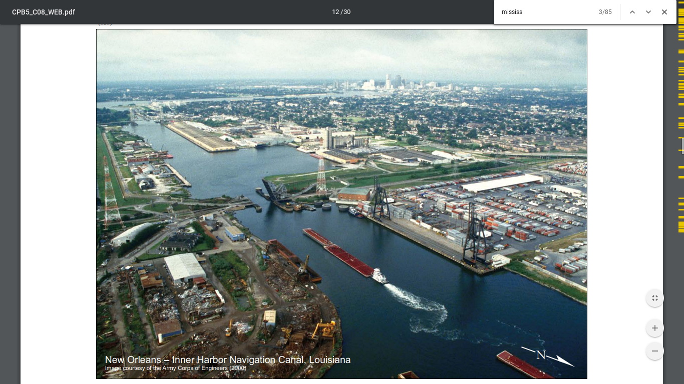
The Industrial Canal—officially known as the Inner Harbor Navigation Canal (IHNC)—is an engineering marvel that has shaped New Orleans’ economy, neighborhoods, and identity since its completion in 1923. Stretching 5.5 miles from the Mississippi River to Lake Pontchartrain, the canal links the city to the Gulf Intracoastal Waterway and the world beyond. Today, it remains a vital artery of commerce and culture, offering visitors a unique window into New Orleans’ maritime legacy, resilience, and ongoing transformation (nola.com, wikipedia).
This guide explores the Industrial Canal’s historical evolution, economic significance, visiting logistics, and key sites. Whether you’re a history buff, an architecture enthusiast, or a traveler seeking off-the-beaten-path experiences in New Orleans, this resource will help you make the most of your visit.
Early Visions and Colonial Era Proposals
The dream of connecting the Mississippi River to Lake Pontchartrain began as early as 1718, when French colonial planners saw the value of a canal to improve trade and transportation. Early maps, including the 1721 “Plan de la Ville de la Nouvelle Orleans,” proposed such a waterway, but engineers were stymied by technical challenges—particularly the elevation difference between river and lake and the risk of uncontrolled flooding (nola.com).
During the Spanish colonial era, the Carondelet Canal connected the French Quarter to Lake Pontchartrain via Bayou St. John, but it stopped short of the river due to similar concerns. The right-of-way for a river-to-lake canal influenced the naming of Canal Street, though the full vision remained unrealized through the 19th century (wikipedia).
19th Century Economic Drivers and Canal Proposals
As New Orleans’ port boomed in the 1800s, driven by the cotton trade and the advent of steamships, calls for a direct river-to-lake canal intensified. Projects like the New Basin Canal and expansions of the Carondelet Canal improved connections to the lake but still didn’t bridge the crucial gap to the river (cabinetofinconsiderations.substack.com). Economic logic was clear: a direct canal would streamline shipping, reduce dependence on railroads, and bolster the city’s status as a maritime hub, but high costs and engineering obstacles delayed progress for decades.
Authorization and Construction in the 20th Century
Momentum surged with the opening of the Panama Canal in 1914, inspiring local leaders to modernize New Orleans’ shipping infrastructure. That year, the state authorized the Port of New Orleans to build a deep-water canal between the river and the lake (wikipedia). After considering five routes, engineers selected a path through the sparsely populated Ninth Ward to minimize displacement and costs (nola.com).
Construction began in 1918, and by January 1923, the canal and its lock system—modeled after Panama Canal innovations—were operational. The dedication ceremony was a citywide celebration, marking a new era of maritime commerce (neworleanshistorical.org).
Industrial Growth and Urban Transformation
The canal’s opening spurred rapid development: shipyards, wharves, grain terminals, and a 150-acre rail yard sprang up along its banks. The Lower Ninth Ward and adjacent neighborhoods grew as jobs attracted working-class residents, including African Americans and immigrants (SAH Archipedia, neworleanshistorical.org). Improved drainage and employment opportunities fostered intergenerational communities.
Integration with National Waterways
In the 1930s, the Industrial Canal became a key leg of the Gulf Intracoastal Waterway (GIWW), linking the city to a national shipping network. The federal government leased part of the canal and lock, integrating operations and eliminating local tolls (wikipedia). During WWII, the GIWW was rerouted to connect directly with the canal, solidifying its strategic importance.
The 1965 completion of the Mississippi River-Gulf Outlet Canal (MRGO) provided a deep-draft shortcut to the Gulf, further boosting traffic and economic impact (wikipedia).
Modernization, Disasters, and Resilience
The canal’s history is also one of vulnerability. In 1965, Hurricane Betsy breached its levees, and in 2005, Hurricane Katrina caused catastrophic flooding after failures in the canal’s floodwalls (wikipedia). In response, the $1.1 billion IHNC Lake Borgne Surge Barrier was completed in 2013, featuring navigable gates to protect against storm surges.
Despite modernization efforts, the original 640-foot lock has become a bottleneck for modern shipping. Plans for a larger replacement lock, first approved in 1956, have faced delays and local opposition due to concerns about disruption and flood risk. The latest design, estimated at $4.7 billion, is under review (NOLA.com).
Legacy and Urban Impact
The Industrial Canal physically divides New Orleans, separating the Lower Ninth Ward from the Upper Ninth Ward and New Orleans East. While it has driven industrial growth and employment, it has also contributed to social and geographic fragmentation (nola.com). Today, it remains a critical part of the city’s infrastructure and is becoming a catalyst for innovation, with redevelopment projects like the Naval Support Activity (NSA) site poised to transform the area into a hub for clean energy and technology (Newlab, Opportunity Louisiana).
Visiting the Industrial Canal: Practical Information
Hours and Access
- Canal & Public Parks: The canal itself is accessible year-round. Parks, observation decks, and walking trails typically open from dawn to dusk.
- IHNC Lock Observation Area: Open daily during daylight hours. Best visited when marine traffic is active.
- Crescent Park: Open 6 a.m. to 11 p.m. daily.
- Bridges and Walkways: Publicly accessible at all times; daylight visits are recommended for safety.
Tickets
- General Access: Free. No ticket required for public outdoor areas.
- Guided Tours: Some local operators offer paid boat or walking tours with historical commentary. Tickets can be purchased online or from tour providers (portno.com).
Transportation & Parking
- By Car/Bike: Street parking is available near major bridges and Crescent Park; check signage for restrictions.
- Public Transit: Neighborhoods like Bywater and the Lower Ninth Ward, adjacent to the canal, are served by city bus and streetcar lines.
- Rideshare: Uber and Lyft are convenient options, especially for reaching less accessible areas.
- Accessibility: Many public areas, including Crescent Park and observation decks, are wheelchair accessible.
Key Landmarks and Points of Interest
- IHNC Lock: See ships move between river and canal; observation decks and signage explain the engineering.
- St. Claude Avenue Bridge: Historic vertical lift bridge, great for watching marine traffic and city views.
- Florida Avenue Bridge: Offers sweeping views of industry and neighborhoods.
- Crescent Park: A riverside park with panoramic views and the iconic "Rusty Rainbow" pedestrian bridge.
- Lower Ninth Ward: Neighborhood known for its resilience, community art, and the Living Museum.
- Naval Support Activity (NSA) Site: Emerging innovation hub focused on clean energy and technology.
Guided Tours and Community Events
- Tours: Walking and boat tours explore the canal’s industrial and cultural history. Advance booking is recommended, especially for in-depth experiences.
- Community Events: Neighborhoods along the canal, like Bywater and Lower Ninth Ward, regularly host festivals, art walks, and cultural gatherings.
Visitor Tips & FAQs
Tips
- When to Visit: October–April offers pleasant weather; early mornings and evenings yield the best light for photography.
- Safety: Stay in public areas, avoid industrial sites, and visit during daylight.
- Photography: Observation decks and bridges provide the best vantage points.
FAQs
Q: Are there entrance fees to visit the Industrial Canal?
A: No, public areas are free. Guided tours may have a fee.
Q: What are the best ways to see the canal?
A: Walking, guided tours, boat excursions, and observation decks on bridges.
Q: Is the canal area family-friendly?
A: Yes, especially parks and observation areas.
Q: Is it accessible for people with disabilities?
A: Many public areas are accessible, but some terrain may be uneven.
Q: Is the area safe for tourists?
A: Yes, in daylight and when using reputable tour operators. Remain alert in unfamiliar neighborhoods.
Listen to the full story in the app
Your Personal Curator, in Your Pocket.
Audio guides for 1,100+ cities across 96 countries. History, stories, and local insight — offline ready.
Audiala App
Available on iOS & Android
Join 50k+ Curators
Sources
- verified
- verified
- verified
- verified
- verified
- verified
- verified
- verified
- verified
- verified
- verified
Last reviewed:


