Mount Kilimanjaro
MoshiTanzania 3° S · 37° E Updated Jul 2026
The Chagga name means roughly 'we failed to climb it' — and most of Moshi's 10,000 porters have never stood on the summit they work.
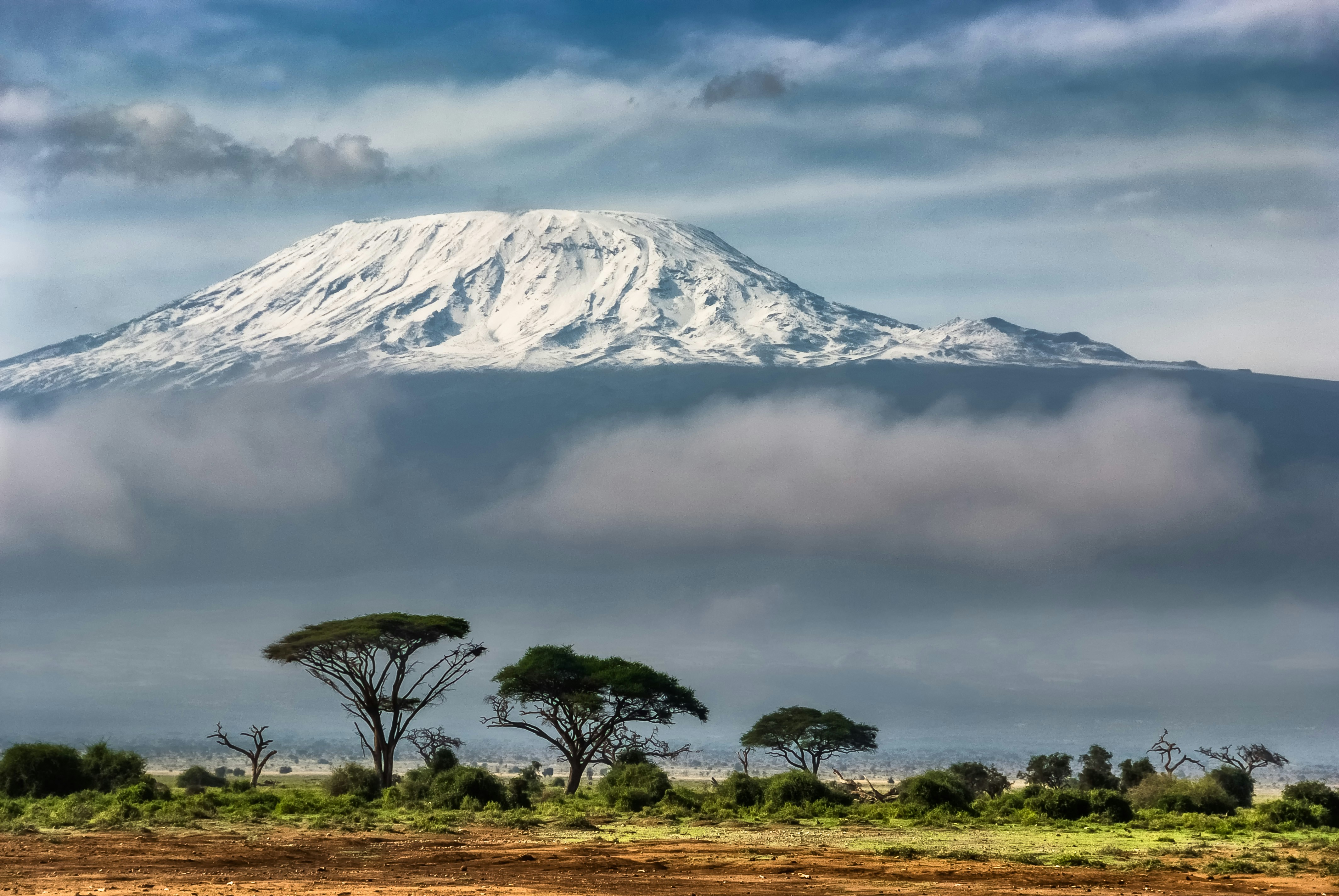 Photo: Sergey Pesterev / Unsplash
- Time needed
- 5-9 days (trek); day trips to the park gates from Moshi
- Entry
- Park fees ~$900-1,300 for a 7-day climb (conservation $70/day + camping $50/night, excl. 18% VAT)
- Access
- Not accessible above the gates; lower forest gates reachable by vehicle
- Best season
- Dry seasons: January-March and June-October
Snow sits three degrees south of the equator here, and for thirty years Europe's leading geographers insisted it was a hallucination. Mount Kilimanjaro lifts 5,895m out of the plains above Moshi, Tanzania — the largest free-standing volcanic mass on earth, close enough that you can watch its ice from a café table in town while sweating through your shirt. Come for that contradiction, and for the walk that takes you from banana groves to glacier in six days without a single rope move.
The massif is three volcanoes, not one. Shira collapsed and went extinct roughly 500,000 years ago and now reads as a high tilted plateau; Mawenzi is the jagged eastern spike that looks like a proper mountain and defeats almost everyone who tries it; Kibo is the smooth dome with the ice cap, dormant rather than dead, still breathing sulphur out of fumaroles inside its crater. Uhuru Peak, the point everyone photographs, sits on Kibo's rim.
Walking up means crossing five climate bands in under 40km of horizontal distance — rainforest thick with colobus monkeys, then heather and giant lobelia, then alpine grassland, then a volcanic desert of scoured scree, then permanent ice. Botanists describe it as travelling from the equator to the Arctic in a week. The comparison is less tidy than it sounds, since the summit's daytime sun burns harder than anything at the poles.
And the real danger isn't the cold or the rock. It's the 4,900m of prominence and how fast you gain it: roughly 45% of trekkers on the short five-day Marangu route turn back, most of them beaten by altitude, not fitness. Marathon runners fail. Sixty-year-olds who walked slowly succeed.
What to see
-
Uhuru Peak — and the 30 metres past it
Everyone stops at the wooden signboard. It sits at 5,895 metres, weathered soft by wind and replaced more than once over the years, and the queue for a photograph beside it can eat twenty minutes of the thin hour you have up there. Take the picture. Then keep walking east.
A rocky ledge sits roughly 30 metres beyond the sign, and almost nobody bothers — which is why it's empty when the sun comes up over the Rebmann and Furtwängler glaciers. At sunrise the ice reads like poured silver, hard-edged and blue-banded where the wind has carved it. Below you, a floor of cloud. Above, nothing at all.
The silence at the top surprises people more than the cold does. Above 5,000 metres there's no vegetation to rustle, no insects, no birds — nothing to make sound and nothing to shelter it. Trekkers describe a quiet so total it seems to have a texture of its own.
-
The Barranco Wall and the Kissing Rock
257 metres of rock rises straight out of the Barranco Valley — roughly the height of a 75-storey tower, climbed with a daypack before breakfast. It's the steepest section of the standard route and it looks impassable from the camp below. It isn't. There's a path, and porters carrying 20 kilos overtake you on it while balancing loads on their heads.
Near the top the path narrows to a shelf around a rock bulge, and the only way past is to press your chest flat to the stone and shuffle sideways. Climbers call it the Kissing Rock. Full body contact with the mountain — it's the most tactile moment of the entire climb, and the one everybody talks about afterwards.
Start early. From the base at dawn, giant groundsels stand in the foreground of every photograph: Dendrosenecio kilimanjari, nearly 9 metres tall, growing straight out of hardened lava with cabbage-like crowns that look distinctly prehistoric in the mist.
-
Five worlds in five days — the ecological climb
No other walk on earth stacks this many climates on top of each other. Day one puts you in montane forest between 1,800 and 2,800 metres, where the air is warm and wet and you hear a branch crack overhead before you spot the black-and-white colobus that broke it. This band alone holds around 69% of the park's bird species and 80% of its large mammals.
Then heath and moorland, where the giant groundsels and lobelias take over. Then alpine desert above 4,000 metres — rock, dust, no shade, and a temperature swing between noon and midnight that shreds anyone who packed light. Then ice.
Walking from equator to arctic in under a week is the actual attraction here, not the summit photograph. Take the extra acclimatisation day the park recommends above 3,000 metres. You'll see more, and you'll be far more likely to make the top.
-
Inside the crater: Furtwängler Glacier and the Ash Pit
Very few climbers see this, because reaching it means sleeping at 5,700 metres in Crater Camp, where a typical night runs −10 °C and occasionally drops to −20 °C. Inside Kibo's crater sits the Reusch Crater, and inside that the Ash Pit: about 400 metres across and 130 metres deep, ringed by sulphur fumaroles that steam.
You smell it before you see it. The sulphur comes and goes with the breeze — proof, at the bluntest possible level, that the mountain is only dormant.
The strangest detail is what isn't there. The shaft is heated from below, so snow never accumulates in it: a bare dark hole sitting in the middle of a glacier field. Stand at Furtwängler's face on the way back and you finally get scale on the ice, which shrank from roughly 11.4 km² in 1912 to about 1.5 km² by 2019.
Plan your visit
- Getting There
- Marangu Gate and park HQ sit 41 km from Moshi — roughly an hour by road, a little more when the tarmac gives out. Kilimanjaro International (JRO) is about 90 minutes away, Arusha 128 km west. No train, no city bus goes to any of the eight gates: your operator's 4×4 transfer is the default, a Moshi taxi the fallback, and self-driving pointless since no vehicle passes the gate.
- Opening Hours
- The park never shuts for the season — you can start a climb any week of 2026. Gates run dawn to late afternoon, with registration closing early enough to walk to the first hut in daylight, so operators aim for a mid-morning arrival. Long rains fall mid-March to May and short rains late October into November, which turns the forest zone to slick red mud; January, February and July through September are the dry windows.
- Time Needed
- Five days is the shortest legal summit itinerary and the one most likely to send you home at Gilman's Point. Seven to nine days is the honest answer — success scales almost linearly with acclimatisation nights. Not climbing? Marangu Gate to Mandara Hut and back is a 7–8 hour forest day with blue monkeys and giant heather; add a day in Moshi before departure for the gear check and one or two after for legs that no longer work.
- Cost & Permits
- Park fees are per person per day and stack: about $70 conservation, $50 a night camping or $60 for a Marangu hut bunk, a one-off $20 rescue levy and $10 forest fee, all before 18% VAT. That's roughly $900–1,300 in government fees for seven days — 50-60% of what you pay, which is why a $1,400 all-in quote means someone on your crew is subsidising it. Full-package market rates run $2,000–4,500. Rates last published for the window ending 30 June 2026, so confirm the current TANAPA tariff when you book.
- Accessibility
- There is no step-free option on any route. The park boundary begins at the 2,700 m contour and the terrain runs forest mud to moorland to loose scree, with summit night a six-to-eight-hour pre-dawn grind; evacuation is by single-wheel stretcher pushed down to the gate. Specialist teams have summited with wheelchair users, but that's an expedition, not a facility. The consolation is real: Kibo is visible for free from half the terraces in Moshi, clearest just after sunrise.
History
The Mountain Europe Refused to Believe In
People have lived on these slopes for a very long time — stone bowls and tools found on the lower flanks have been read as settlement from around 1000 BC, though that dating rests on thin evidence. What's better attested is the Chagga arrival, traditionally placed around the 11th century, and their organisation into dozens of sovereign chiefdoms each ruled by a mangi. German administrators counted roughly 28,000 Chagga households on the mountain around 1900.
The mountain reached European paper long before it reached European feet. Ptolemy's geography describes a great snow-covered mass inland from the Zanj coast in the 150s AD; the Arab geographer Abu'l-Fida repeats the report around 1300. Nobody in Alexandria or Damascus went to look. The coast traded, the interior stayed rumour, and the rumour survived fifteen centuries mostly intact.
The turning point
The Guide Whose Name Wasn't on the Flag
The official version is clean and easy to repeat. On 6 October 1889 the German geographer Hans Meyer and the Austrian alpinist Ludwig Purtscheller stood on the highest point of Kibo, planted a flag, christened the summit Kaiser-Wilhelm-Spitze and declared it the highest mountain in Germany. First ascent, scientific triumph, imperial trophy, all in one morning. Meyer had personally funded it and had a great deal riding on it — two previous failures, drained finances, and a European academic establishment still half-convinced that equatorial snow was an error of observation.
But look at those two failures. Meyer was turned back in 1887 and again in 1888, and the accounts that survive blame altitude sickness and local resistance in roughly equal measure. Resistance is the word doing quiet work there. Something changed between the second attempt and the third, and it wasn't Meyer's lungs.
What changed, according to the tradition kept alive by guiding families in Marangu, was a Chagga teenager named Yohanas Kinyala Lauwo, who agreed to walk ahead of the two Europeans and show them the ground. For a young Chagga man this was not a job offer. Chagga teaching held that the ice on Kibo belonged to Ruwa, that only spirits walked up there, and that a human who tried it would not come back — elders had been saying so for generations, and the refusal of earlier porters was obedience, not superstition-as-obstacle. The turning point was the moment Lauwo kept climbing past the last heather. He survived, went on to become Tanzania's first official mountain guide, and the tradition holds he lived to 115. Both the age and the claim that he was the first African on the summit are single-source and contested; what matters is that Marangu's guides have kept telling it for over a century, as a counter-claim to a story where Africans appear only as luggage.
So when you reach Uhuru Peak and queue for the photograph at the wooden sign, look at what's written on it. The name is Swahili for freedom, applied at independence in 1961 to erase a Kaiser. No name of any guide appears anywhere on that summit — and yet somewhere between 30,000 and 50,000 people a year get there only because a chain of Chagga guides descending from Lauwo's generation knows the ground. The mountain's most famous first is really a second.
The Snow That Didn't Exist
From Kaiser's Peak to Uhuru
Tips for visitors
Vet Your Operator
The scam here isn't pickpockets, it's the flycatcher at the airport selling a discounted climb that arrives without a licensed guide. Check the company against the TATO directory at tato.or.tz and KPAP's partner list at kiliporters.org, phone a number you found yourself, and pay by credit card rather than wire transfer.Pole Pole Is Not A Joke
You'll hear "pole pole" — slowly, slowly — several hundred times, because walking faster than your guide is the single most reliable way to fail. Route and acclimatisation days matter more than your fitness; the extra night costs less than flying back to try again.Settle The Tip First
Tip shakedowns at the descent gate are a recurring complaint. Agree the total and how it splits between guides, cook and porters with your lead guide in writing before you leave Moshi, and bring the cash in small US dollar notes.Leave The Drone Home
Flying inside the park needs written TANAPA authorisation plus TCAA clearance, and approvals go to documentary crews and researchers — not to personal travel filming. Unpermitted drones get confiscated on arrival at JRO. Phones and handheld cameras are unrestricted, but ask before photographing porters or Chagga villagers; posed portraits often carry a fee.Drink The Cooperative's Coffee
Union Café at Arusha Road and Selous Road is owned by KNCU, the Chagga growers' cooperative founded in 1929 — a milk coffee runs around TZS 4,000, a cold brew with ice cream about 12,000. Kilimanjaro Coffee Lounge has the garden and the better pizza. Both are budget-to-mid for a visitor and where every guide, expat and NGO worker in town ends up by 10am.Say Yes To Mbege
Chagga banana beer, brewed by women from ndizi ngombe bananas, sprouted finger millet and quinine-tree bark — sweet up front, bitter at the finish, somewhere between wine and cider. Villages around Marangu pour it at weddings, funerals and bride-price talks. Being offered a gourd is being included; refusing is the rude part, not the taste.Summit Cold Is Real Cold
Kibo's crater rim runs from around −1 °C down to −25 °C before windchill, three hours after you left a camp where you were sweating. Thermal base layers, an insulated synthetic coat and a hooded shell aren't optional, and headlamp batteries die fast up there — carry the spares inside your jacket.Don't Walk Moshi At Night
The town is friendly and walkable by day, with police visible on the main streets. After dark the lights are poor and the streets empty fast — robberies have been reported in Shantytown, the leafy expat quarter, disproportionately against women walking alone. Take a taxi; it costs a few thousand shillings.
Frequently asked
Is climbing Mount Kilimanjaro worth it?
Yes — it's the only place on earth where you walk from equatorial rainforest to arctic ice in under a week, no ropes required. Uhuru Peak sits at 5,895m, the highest point in Africa and the largest free-standing volcanic mass on the planet, and you reach it on your own two feet. But accessible doesn't mean easy: altitude sickness, not technical difficulty, is what turns people back.
How many days do you need to climb Kilimanjaro?
Five days minimum, seven to nine if you actually want to summit. Success rates scale almost directly with days on the mountain, because every extra night is another night your blood makes red cells. TANAPA recommends adding an acclimatisation day at any camp above 3,000m, plus a day in Moshi beforehand for briefing and gear checks.
How do I get to Mount Kilimanjaro from Moshi?
Marangu Gate and the park headquarters sit about 41km from Moshi, roughly an hour by road, and almost everyone arrives in their operator's 4×4 as part of the package. Kilimanjaro International Airport (JRO) is about an hour from the park on the other side. There's no train, no city bus to the gates — and self-driving is pointless, since no vehicle goes past the gate.
What is the best time to climb Kilimanjaro?
Two dry windows: December to mid-March, and late June through October, with January, February, July, August and September the most reliable months. The trade-off is counterintuitive — the warmest, driest months give you the least snow on the summit, while January to March is colder but far more likely to hand you the postcard ice cap. Avoid the long rains from mid-March to May and the short rains around November, when routes turn to mud.
Can you visit Mount Kilimanjaro without climbing it?
Yes, and plenty of people should. A single-day permit gets you through Marangu Gate into the montane forest — the Mandara Hut return is roughly seven to eight hours, with black-and-white colobus crashing through the canopy overhead and Maundi Crater's panorama into Kenya a short walk further on. From Moshi itself the mountain costs nothing to look at, and it's clearest early morning and around sunset.
How much does it cost to climb Kilimanjaro?
Park fees alone run roughly $900–1,300 per person for a seven-day climb, typically half to sixty percent of the total price. The tariff stacks up per day: about $70 conservation fee, $50 a night camping or $60 for a Marangu hut, a $20 rescue levy, plus 18% VAT on top — and rates change, so confirm current figures with TANAPA before budgeting. Full packages commonly land between $2,000 and $4,500.
What should I not miss on Mount Kilimanjaro?
Walk about 30 metres east past the wooden summit sign — almost nobody does, and that ledge gives you an uninterrupted view of the Rebmann and Furtwängler glaciers with no queue in the frame. Lower down, the Barranco Wall's "Kissing Rock" forces you chest-to-stone to shuffle round a bulge, the most physical contact you'll have with the mountain all week. And if your itinerary includes Crater Camp, the Ash Pit — 400m across, 130m deep, heated from below so snow never settles in it — is a hole that stays bare inside a snowfield.
Do you need a guide to climb Kilimanjaro?
Yes — independent trekking is not permitted, and every route requires a KINAPA-licensed guide booked through an operator. Choose that operator carefully: a suspiciously cheap quote usually means someone on your crew is underpaid or underfed. Check the operator against the TATO directory and KPAP's partner list, agree tip amounts with your lead guide in writing before departure, and pay by card rather than wire transfer.
Sources & attribution 16
- Tanzania Tourism — Mount Kilimanjaro National Park — Official park page: distances from Moshi and JRO, gate list, climbing seasons and rains, summit temperatures, acclimatisation and trip-length advice, ecological zones.
- UNESCO World Heritage Centre — Kilimanjaro National Park — World Heritage inscription of the park as the largest free-standing volcanic mass on earth.
- UNESCO / TANAPA exhibit on Google Arts & Culture — Vegetation zonation, mandatory licensed guiding, recommended acclimatisation day above 3,000m, viewpoints and sanctioned activities.
- Altezza Travel — Kilimanjaro park fees — Breakdown of conservation, camping, hut, rescue and crater fees, VAT, and park fees as a share of total climb price.
- Climbing Kilimanjaro — National Park fees — Corroborating fee structure and typical seven-day park fee totals.
- Ultimate Kilimanjaro — Best time to climb — Dry and rainy season windows, best months, and month-by-month conditions.
- Wilderness Travel — Best time to hike Kili — Trade-off between the warm dry season and the colder January–March window with better summit snow cover.
- Ultimate Kilimanjaro — Reusch Crater and the Ash Pit — Ash Pit dimensions (~400m wide, ~130m deep), fumaroles, and why snow does not accumulate inside it.
- Eddy Tours — What's at the top of Mount Kilimanjaro — The wooden Uhuru Peak signboard and the glacier-viewing ledge a short walk east of it.
- Tranquil Kilimanjaro — Barranco Wall — Barranco Wall height and the Kissing Rock squeeze near the top of the climb.
- Follow Alice — Mandara Hut trekker's guide — Montane forest conditions, colobus monkeys, Mandara Hut clearing and the Maundi Crater walk.
- Tranquil Kilimanjaro — One-day Marangu trek — The no-summit day-hike option into the forest zone via Marangu Gate.
- Local Moshi Adventures — Local perspective on operator and route choice mattering more than fitness, and skepticism about self-reported success rates.
- Rolux Safaris — Avoiding tourist scams in Tanzania — How to verify operators via TATO and KPAP, and payment advice.
- Kilimanjaro Park — Cultural and human dimensions — Chagga sacred meaning of Kibo, guiding tradition from Yohanas Kinyala Lauwo, and cultural sites around Marangu.
- Wikipedia — Mount Kilimanjaro — Summit elevation, three volcanic cones, park establishment and general background.
Built from cited sources · see the method · How we make our guides →
Pick up where you left off
Saved and recently read places — kept on this device only.
Photo credits (3)
- David Clode — Unsplash License (https://unsplash.com/license) — Source: https://images.unsplash.com/photo-1535075303792-2c5c8d2aa7f7
- Kristoffer Darj — Unsplash License (https://unsplash.com/license) — Source: https://images.unsplash.com/photo-1611961547440-bde7c756990f
- Sergey Pesterev — Unsplash License (https://unsplash.com/license) — Source: https://images.unsplash.com/photo-1613061445510-e296bfedb73e
Photos may have been resized or cropped.