Type 2+ letters to search all countries, cities, and places
/Ctrl KEsc
travel_explore
Type 2+ letters to search all countries, cities, and places
Press Enter to open the top result
Teide
Santa Cruz De Tenerife·Spain·28° N · 16° W·Updated Jul 2026
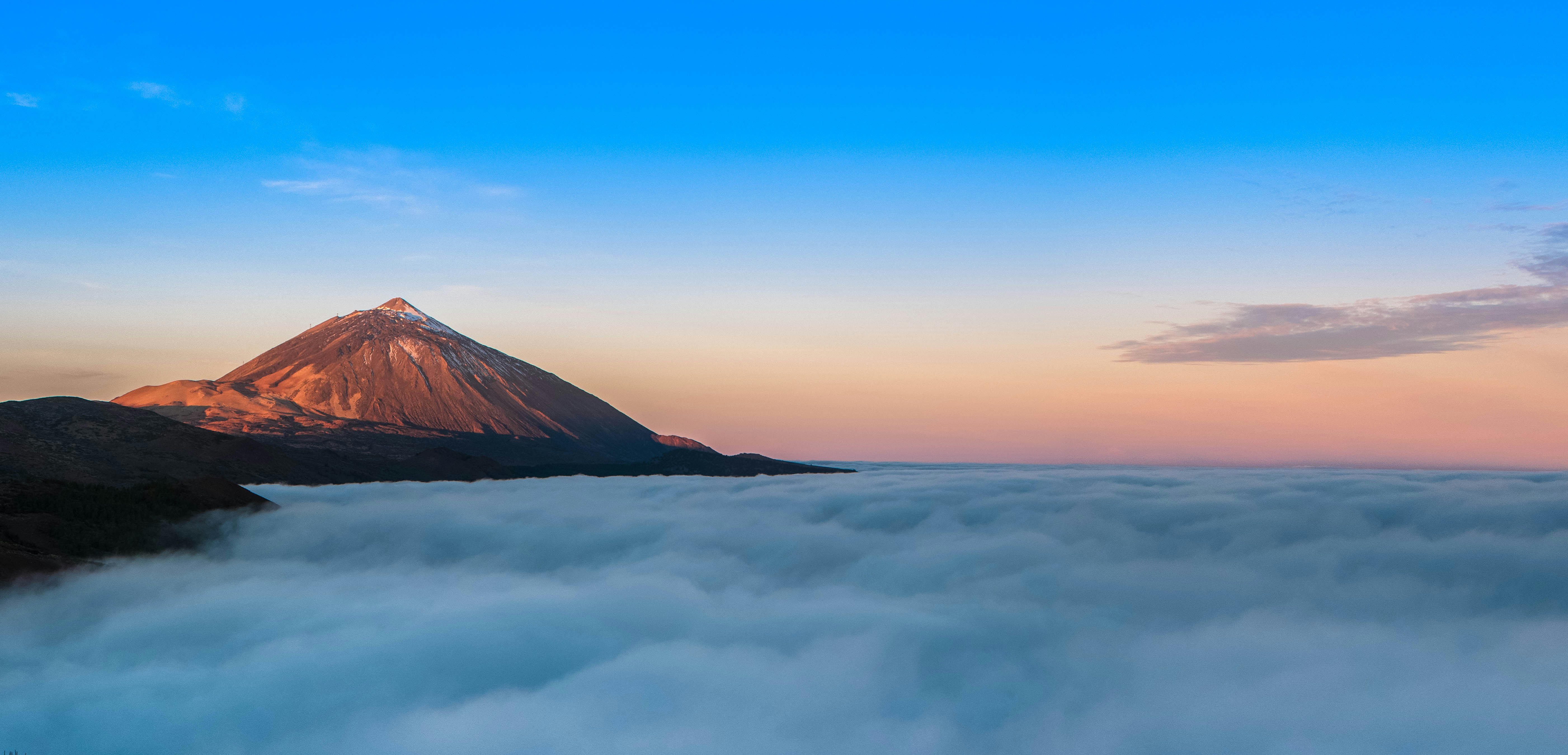
Rising 7,500 meters from the seabed, Spain’s highest peak crowns a vast UNESCO caldera where ancient Guanche legends echo beneath Europe’s clearest skies.
Free park entry; cable car & permits require booking
Access
Cable car accessible; high-altitude trails are steep and rugged
Best season
Year-round (clearest skies Oct–Apr)
Exactly 7,500 meters of submerged basalt separate the quiet asphalt parking lot from the pressurized magma chamber that built this entire island. You visit to climb. Rising to 3,718 meters in Santa Cruz de Tenerife, Spain, El Teide forces you to trade coastal humidity for thin air and obsidian trails. Walk the high ridges.
Geological surveys confirm the mountain last vented smoke in 1909, but modern scientists monitor its 86°C fumaroles around the clock. The peak does not sleep. Cable cars replaced mule tracks in 1971, yet the only permitted route to the summit still follows a dirt path named for a geologist who refused to let political purges erase his life's work. He mapped it all.
Most visitors snap photos from La Rambleta and leave before the afternoon wind picks up across the dry caldera floor. Walk carefully. Phonolite boulders fracture the skyline along Trail 10, where ancient caldera walls drop away like a shattered dinner plate across the valley. Step lightly.
Researched by the Audiala editorial team from historical records, architectural archives, and local expertise.
What to see
Roques de García & Llano de Ucanca
Step off at the Mirador de la Ruleta and you drop into a 25-kilometer collapsed amphitheater where the caldera walls climb 600 meters high, taller than two Eiffel Towers laid on their sides. Listen closely. Flat lajial plates ring under your boots like broken slate as you follow the PNT 3 trail toward the Llano de Ucanca plain, where the gravity-defying Roque Cinchado stands exactly as it did on the back of every 1,000-peseta note your grandparents carried.
El Portillo Visitor Centre
Architects usually fight nature on this island, but the El Portillo Visitor Centre deliberately loses, sinking its low, recessive lines into the northern slope until black pumice swallows the edges. Step inside. The main corridor narrows into a simulated volcanic tube, dropping the ambient temperature and echoing your footsteps against cool concrete while living tajinaste spikes reach two meters high in the adjacent garden.
La Rambleta to Mirador de Pico Viejo
Skip the crowded summit queue and take the PNT 12 trail from La Rambleta instead, where the air thins at 3,555 meters and forces you to match your breathing to your bootfalls. Breathe slowly. You’re walking toward Pico Viejo, a 3,134-meter neighbor whose crater spans 800 meters across, ten times wider than Teide’s own cramped peak, leaving you to stand on the rim and watch petrified lava rivers draw capricious patterns across a rust-colored floor.
Plan your visit
Getting There
Teide sits in Tenerife's interior, not in Santa Cruz city: from Santa Cruz de Tenerife the prettiest drive is TF-24 via La Esperanza, about 1 hour 15 minutes to 1 hour 30 minutes through pine forest and up to the caldera. North approach: TF-21 from La Orotava or Puerto de la Cruz takes about 1 hour; south approach: TF-21 from Los Cristianos about 1 hour; west approach: TF-38 from Chio or Los Gigantes about 1 hour. Public transport is thin: no direct guagua from Santa Cruz, and the usual 108 plus 348 connection takes roughly 2 hours 30 minutes, with 342 and 348 schedules changing in 2026, so check TITSA before you build a day around them.
Opening Hours
As of 2026, Teide National Park itself is open 24 hours a day, with no park gate and no entry fee. The cable car usually starts at 09:00 and closes between 17:00 and 18:40 depending on season, with last ascent published between 16:00 and 17:40 and last descent between 16:50 and 18:30. Wind, ice, and snow shut it fast; check the operator status page the same morning, because weather cancellations are common.
Time Needed
Give the bare-minimum cable-car visit 1 hour 30 minutes to 2 hours on site, then add your drive: the ride itself lasts 8 minutes and lifts you almost 1,000 vertical meters, roughly the height of three Eiffel Towers stacked base to tip. Plan 2 hours 30 minutes to 3 hours if you add one top-station trail such as Pico Viejo or La Fortaleza, 5 to 6 hours for a self-drive half day with Roques de Garcia and miradores, and a full day if you want the park loop, sunset, or the Montaña Blanca summit hike.
Accessibility
The hardest truth first: as of 2026, the cable car does not accept visitors with physical or motor disabilities, including wheelchair users, because emergency evacuation from the upper station requires a steep descent on foot. The accessible way to experience Teide is by car: El Portillo Visitor Centre and some viewpoints and short routes in Las Cañadas are the best starting points, while many scenic stops have sloped ground, loose lava gravel, and thin air at altitude. Organized coach tours can take folding wheelchairs in some cases, but passengers generally need to board unaided.
Cost & Tickets
As of 2026, the park is free; the paid piece is the cable car, with adult return tickets at 42 euros, children aged 3 to 13 at 21 euros, and return plus audioguide at 45.50 euros. Canary Islands resident fares drop sharply, to 10.50 euros for an adult return, but proof of residency matters, and children under 3 are not admitted. The crater trail above La Rambleta needs a separate Tenerife ON permit; 2026 booking rules use timed slots and published fee bands that reach 15 euros for non-residents, so book ahead and verify the current tier when you reserve.
History
The Caldera's Long Memory
Before Spanish galleons charted the Atlantic, Guanche herders called the 16-kilometer basin Echeyde, a name that translates roughly to hell. It served as a threshold.
The conquest of 1494–1496 permanently shifted the volcanic mountain from sacred ground to a contested imperial frontier for Spanish settlers. Land grants followed. Scientists later arrived with heavy barometers and brass compasses, trading local myth for empirical measurement across the highlands and coastal ports. They mapped everything.
The turning point
Bravo's Ascent
Telesforo Bravo López arrived at the volcano in the 1930s carrying a satchel of field notebooks and a career hanging by a thread. He needed funding. The Spanish Civil War had purged university faculties, and the Franco regime viewed independent researchers with open suspicion and quiet hostility. He mapped carefully.
His turning point finally arrived on a wind-scoured caldera ridge during the dry summer of 1954, when he presented his surveys to the Ministry of Agriculture. The ministry accepted his data. His detailed classification of phonolite domes and basaltic vents became the legal backbone for Spain's first high-altitude reserve and research station. They signed the decree.
Today, the official summit route carries his name on every trailhead sign and topographic map published by the park service. Walk it carefully. Bravo survived political exile and academic marginalization to permanently anchor the entire volcanic complex in formal geological science and public conservation efforts. He won.
The 1706 Harbor Burial
Montaña Negra opened a deep fissure in 1706 and poured nine days of molten basalt directly into Garachico's commercial harbor. Townspeople panicked. Local leaders had repeatedly skipped coastal defense taxes, assuming the mountain's tremors were harmless background noise for generations of merchants. Lava cooled fast.
Columbus's False Beacon
En route to the Americas in 1492, Christopher Columbus's crew recorded a massive fire glowing from the distant Orotava Valley. He logged it. Modern volcanologists strongly suspect a minor phreatic vent or a wind-driven forest fire caused the distant glow that Columbus witnessed. It misread well.
Tips for visitors
La Rambleta Secret
The cable car does not take you to the summit. If the crater permit is gone, walk the free side trails from La Rambleta instead: Pico Viejo gives you an 800-meter-wide crater, like staring into a rust-red stadium, and La Fortaleza opens the north face and the cloud sea.
Dress for Altitude
Teide catches out people who leave the coast in shorts and beach sandals. The top station sits 10 to 15 degrees Celsius colder than the shore, wind cuts hard, and the sun at 3,555 meters bites faster than it feels, so wear closed shoes, carry a windproof layer, and pack sunglasses and high-factor sunscreen.
Shoot, Don’t Fly
Personal photography is fine, and Teide's late light turns the pumice and lava into ash pink and copper. Drones are prohibited without park authorization, and if you stay for stargazing, skip flash and white headlamps unless you want every telescope operator within earshot glaring at you.
Check the Wind
Teide's most common plot twist is a cable-car shutdown after you've already driven up. Check the live operating status before breakfast, not from the parking lot, because high wind and frost can wipe out your slot with no warning and change the whole shape of the day.
Eat Below Treeline
Food inside the park is thin: the Parador de Las Cañadas is the one proper sit-down option, good for a mid-range to splurge lunch with volcano views. For better value, stop in Vilaflor on the south approach at Casa Pana or Restaurante Teide Flor for papas arrugadas, queso asado, and garbanzas, or grab sandwiches at Dulcería Hermano Pedro before you climb higher.
Pair It Properly
Roques de Garcia pairs well with a cable-car day, and El Portillo works better than another roadside stop if you want exhibits, easier walking, and a calmer read on the park. Sunset chasers should aim for the Teide shadow from a mirador or an Izaña stargazing session; locals rate that triangular shadow over the ocean above the summit selfie for good reason.
Where to Eat
local_dining
Don't Leave Without Trying
Papas arrugadas con mojo—wrinkled boiled potatoes with palmero pepper sauce (island signature)Mojo rojo—paprika & cumin pepper sauce for meat/potatoesMojo verde—parsley sauce for fresh fishFresh grilled Atlantic fish—daily catchPuchero canario—slow-cooked meat & vegetable stewConejo en salmorejo—marinated rabbitGoat cheese—fresh through aged/smoked varietiesGofio—toasted grain flour (desserts & stews)Canarian bananas & tropical fruit
Restaurante Rincón de Pedro
local favorite
Canarian Traditional€star4.8(2608)
Order: Meat and seafood dishes—clean plates, no survivors. Owner celebrates birthdays with potato-candles and celebratory shots.
Family-owned. Owner treats you like cousins at Sunday cookout. Best local food in the city; where locals eat.
checkGuachinche = informal family eateries, home Canarian food, house wine. Seek out.
checkPapas arrugadas con mojo: the staple. Order everywhere.
Food districts:Fish market district (Mercado Nuestra Señora de África)—hub of seafood eating. Multiple restaurants inside & near stalls.
Restaurant data powered by Google
Frequently asked
Is Teide worth visiting?
Yes, because it rises 7,500 metres from the Atlantic floor to a 3,718-metre peak that shifts colour with every hour. You’ll walk across lava flows so young the rock still rings under your boots, then stand at La Rambleta where thin air makes your temples pulse. Skip the summit queue for the free Mirador de La Fortaleza trail instead.
How long do you need at Teide?
Plan a full day if you want to drive the TF-21, hike Roques de García, and ride the cable car before the afternoon wind shuts it down. The ascent takes eight minutes, but you’ll easily spend three hours tracing Pico Viejo’s 800-metre crater and watching light shift across pale pumice.
How do I get to Teide from Santa Cruz de Tenerife?
Drive 65 kilometres northwest on the TF-24 highway, which climbs through pine forests and drops you at the caldera rim in roughly ninety minutes. Public buses only run on weekends and public holidays, so rent a car or book a coach. Fill your tank in La Laguna, because there are no petrol stations past the 2,000-metre mark.
What is the best time to visit Teide?
Go midweek in November or February if you want to catch the rare cone snow without fighting crowds. The sky stays clear year-round, but summer afternoons bring sudden wind fronts that cancel the cable car and drop temperatures fifteen degrees below the coast. Check the operator’s webcam at 08:30 before you leave.
Can you visit Teide for free?
Yes, the park roads, viewpoints, and forty-one marked trails are completely open to the public. You only pay €42 for the Teleférico cable car, which stops at La Rambleta rather than the actual summit. Walk the free Pico Viejo trail instead.
What should I not miss at Teide?
Start at the Roque Cinchado spire, which appeared on the old 1,000-peseta banknote and anchors the 4.5-kilometre Roques de García loop. Then step into the simulated lava tube at El Portillo Visitor Centre to see why the Guanches named this place Echeyde. The silence at 3,555 metres is heavy enough to hear your own breathing.
Sources & attribution6
Researched and written by the Audiala editorial team from historical records, architectural archives, and local expertise. Last updated July 2026.
UNESCO World Heritage Centre — Official summit elevation (3,718 m), volcanic structure ranking, and UNESCO inscription criteria.
Volcanoteide Official Operator — Cable car pricing, operating hours, wind closure protocols, and accessibility restrictions.
Tenerife ON Permit Portal — Summit permit requirements, daily caps, and trail regulations above 3,555 m.
Canarias Nature Guides — Pico Viejo crater dimensions, Roques de García trail details, and Guanche Echeyde mythology.
TITSA Public Transport — Weekend-only bus schedules and public transport limitations for accessing the caldera.
WebTenerife Climatology — Winter snow patterns, temperature drops at altitude, and seasonal visiting advice.
Strictly necessary cookies keep the site working. Analytics (PostHog, Google Analytics) measures how each visitor uses our pages. Marketing loads YouTube videos and walking-route maps without a tap and lets Google Analytics set advertising cookies. We never sell your data. You can change this any time from the footer.
Analytics and marketing cookies are optional and only load if you agree. Details under Customize.
Privacy
Cookie preferences
Pick what you're okay with. You can change this any time from the footer.
Strictly necessary
Always on
Sign-in, language, navigation. Always on.
Product analytics
PostHog (EU) and Google Analytics record which pages you view and how you use them, under a random identifier stored in your browser. Helps us see which pages work and which need fixing. Google's ad personalisation stays off. No selling.
Marketing
Loads YouTube videos and the walking-route maps (OpenFreeMap) without a tap; without it, they load only when you tap them. If analytics is also on, Google Analytics may set advertising cookies. Ad personalisation stays off.