


Place
Queenstown
New Zealand Updated Apr 2026
Coal smoke from a 1912 steamship can still drift across the water here, and that tells you something about Queenstown, New Zealand straight away: beneath the bungee footage and ski posters, this town keeps a grip on its older selves. Lake Whakatipu does the heavy visual work, all cold blue light and long mountain shadows, but the real surprise is how quickly Queenstown shifts mood. One block holds burger queues and cocktail bars; ten minutes later you're on a lakeside path with gulls, wet stones, and silence.
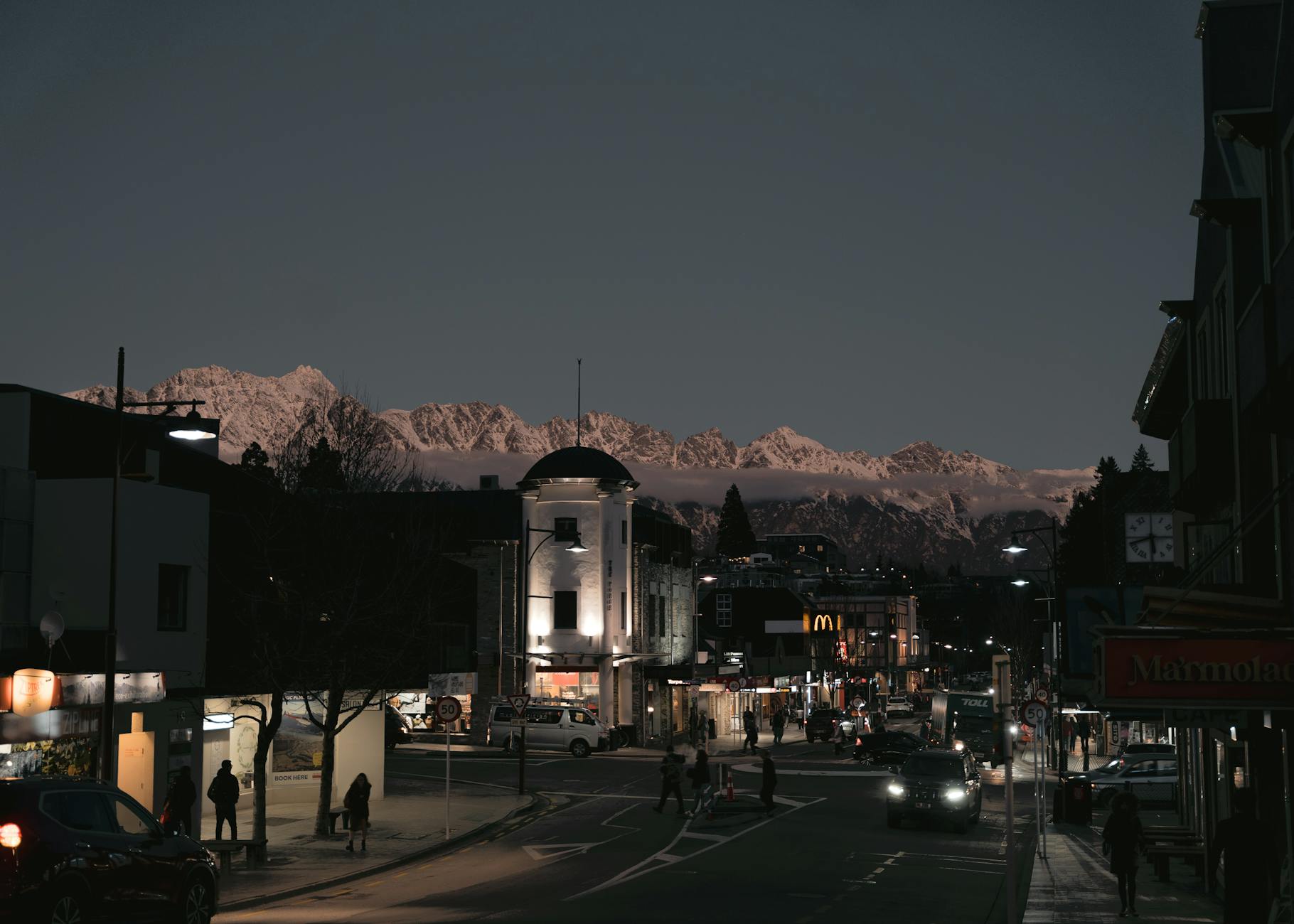 Photo: kari Kittlaus / Pexels
- Attractions
- 12
- Trip length
- 3-5 days
- Best season
- Autumn (March-April)
Why Queenstown
Built from cited sources · see the method · How we make our guides →
Queenstown sells adrenaline, and yes, the town has earned that reputation. The stranger, better truth is that it works because three different places overlap here: a resort town pressed against a deep glacial lake, a gold-rush district whose history survives in fragments and side roads, and a small arts scene that has grown up in old classrooms, community venues, and the serious Frankton hub of Te Atamira.
Its geography shapes your day more than any itinerary will. Bob's Peak rises almost absurdly close to the center, Ben Lomond turns a morning stroll into a 1,438-meter climb, and the shore keeps pulling you back with views toward Cecil Peak, Walter Peak, and The Remarkables, whose name sounds like marketing copy until the late light hits them and proves otherwise.
Queenstown makes more sense once you stop treating the center as the whole story. The lakefront is only the front room; the deeper character sits out in Arrowtown's 1860s main street, in Gibbston's cellar doors, in Arthur's Point breweries, in Kiwi Park's conservation work, and on quiet detours like Sunshine Bay or Bob's Cove, where the town's noise drops away and the basin starts to feel large again.
Lake Whakatipu Drama
Queenstown lives by the water, and Lake Whakatipu gives the town its whole emotional pitch: long blue light, sudden wind, The Remarkables rising behind the roofs like a stage set that forgot to be subtle. Ride the gondola to Bob's Peak, walk Queenstown Hill, or just stand by the wharf at dusk and watch the mountains turn from steel to ash.Gold-Rush Fragments
The place sells adrenaline, but its older story still shows through in useful, stubborn pieces: the 1912 TSS Earnslaw, Eichardt's lakefront history, Arrowtown's 1860s main street, and the Kawarau Suspension Bridge where transport history and bungy mythology now share the same river gorge. Queenstown's architecture isn't grand. It survives in precincts, reused buildings, stone ruins, and the odd structure that kept working long enough to become heritage.A Real Arts Pulse
For a town this size, Queenstown has more cultural muscle than first glance suggests. Te Atamira in Frankton has become the clearest sign of that shift, with gallery, performance rooms, studios, and a year-round program, while Arrowtown's museum and galleries give the district its historical and visual depth.Beyond the Adrenaline Brand
The better secret is how quickly Queenstown turns quiet once you leave the waterfront script. Bob's Cove, Mt Crichton, Sunshine Bay, Wilson Bay, and Moke Lake all sit close enough for a half-day detour, and each swaps helicopter noise for birdsong, wet schist, and the sound of water moving through old mining ground.
Places to Visit
Not every monument, just the ones we'd walk you past ourselves.
Neighborhoods
Where to wander, by quarter — each with its own rhythm.
Central Queenstown
This is the compact core around Shotover Street, Camp Street, and the waterfront, where Queenstown's appetite for energy is most obvious. You'll find the famous burger lines, tour desks, lakefront hotels, late bars, and a constant churn of people in ski boots, hiking shoes, and dinner clothes; useful, lively, and occasionally exhausting.Steamer Wharf and the Lakefront
The lakefront is Queenstown's public stage, and Steamer Wharf gives it a slightly theatrical edge. The TSS Earnslaw ties up here, drinks spill onto decks above the water, and the smell of the lake mixes with fried food and cold evening air; come for the views, but know this stretch belongs more to visitors than to local daily life.Queenstown Gardens
At the eastern edge of town, Te Kararo Queenstown Gardens softens the pace without asking you to leave the center. Mature trees, rose beds, disc golf, and a shoreline loop make this the part of Queenstown where people actually pause, and the light over the Frankton Arm near dusk can feel almost indecently calm after downtown.Frankton
Frankton is where Queenstown starts acting like a real town instead of a postcard. Near the airport and Remarkables Park, you'll find better parking, more everyday cafes, breweries like Altitude, practical shopping, Te Atamira's serious cultural program, and restaurants that locals fold into ordinary life rather than holiday ritual.Arthur's Point
A few kilometers north of the center, Arthur's Point has a rougher, less polished edge that suits it. The Shotover River runs cold and fast nearby, Canyon Brewing gives the area a social anchor, and the whole district feels like Queenstown exhaling after the waterfront performance.Sunshine Bay
Three kilometers west of town, Sunshine Bay is what Queenstown looks like once the volume drops. The beach is small, amenities are minimal, and Cecil Peak sits across the water like a painted backdrop, but that restraint is the point; locals come here for a swim, a short walk, or a sunset that doesn't require a booking.Arrowtown
Arrowtown sits about 20 minutes away, but treating it as optional is a mistake. Buckingham Street still carries more than 60 historic buildings, the Chinese Settlement forces a harder look at the district's gold history, and the whole place offers the heritage depth Queenstown proper only hints at in fragments.Gibbston
Gibbston is less a town center than a wine-growing corridor stretched along the Kawarau Gorge, and that loose shape is part of its appeal. Cellar doors, pinot noir, bike trails, and long lunches replace Queenstown's compressed intensity, with the old suspension bridge and the river giving the area a harder edge than the tasting rooms first suggest.
Plan your trip
Before you go
- Getting There
- Queenstown Airport (ZQN) in Frankton is the main gateway, with direct 2026 domestic flights from Auckland (AKL), Wellington (WLG), and Christchurch (CHC), plus Australian links from Sydney (SYD), Melbourne (MEL), Brisbane (BNE), and the Gold Coast (OOL). Queenstown has no passenger rail and no main train station, so arrivals are by air or road. The town sits on State Highway 6, with State Highway 6A serving Frankton and the airport; most self-drivers arrive via Cromwell on SH6, Glenorchy Road from the west, or the Crown Range route toward Wānaka.
- Getting Around
- Queenstown has no metro, tram, or passenger rail in 2026; local transport runs on the Orbus network, with six bus routes and one scheduled ferry connection centered on Stanley Street downtown and the Frankton Bus Interchange. The Bee Card is the smart buy: NZ$5 for the card, then adult bus fares drop to NZ$2 instead of NZ$10 cash, with free bus-to-bus transfers within 45 minutes; the ferry is separate at NZ$10 with Bee Card or NZ$14 by bank card. Walking works well in the center, and the 150 km Queenstown Trail network plus the completed Arthurs Point to Queenstown shared path make cycling a serious option, not just a holiday extra.
- Climate & Best Time
- Queenstown's 2026 visitor guidance breaks the year into clear bands: summer runs about 20-30C, autumn 5-25C, winter -4 to 8C, and spring 8-22C. NIWA and MetService describe an inland climate with relatively low rainfall, roughly 900 mm a year, plenty of sunshine, and dry spells that can stretch through summer; weather still turns fast once you head uphill. December to February is peak for lake days and long evenings, July to August for ski traffic, and the sweet spots are March to April for autumn color or late September to November for lighter crowds and mixed hiking-bike-snow conditions.
- Language & Currency
- English is the everyday language, though you'll hear and see te reo Maori in greetings and place names; 'kia ora' never sounds out of place. New Zealand's currency is the New Zealand dollar (NZD), card payment is standard, and displayed prices already include 15 percent GST. Tipping isn't expected, and if you pay cash the total is rounded to the nearest 10 cents because 1c, 2c, and 5c coins are gone.
- Safety
- Queenstown's main risks are topographic, not urban: steep hikes, sudden weather, winter roads, and visitors who mistake a scenic drive for an easy one. Ben Lomond is the classic example, with 1,438 meters of ascent from town, rapid exposure changes, and no water beyond the Skyline complex; the Glenorchy road and Crown Range need extra care in winter. For 2026, one date-specific caution matters: Skippers Bridge has been closed to all users since January 12, 2026, despite older tourism material still mentioning the area.
Queenstown: Gold, Steam, Snow, and a Lake Older Than Memory
From Māori seasonal camps on Tāhuna to a global resort balanced between heritage and speed
- c. 15,000 BCE
Ice Carves the Basin
Long before anyone named this place, glaciers cut the trench that became Lake Whakatipu and the Wakatipu Basin. The shape of modern Queenstown begins here: steep walls, cold blue water, and a shoreline that still feels too dramatic to be accidental.
- c. 1200
Seasonal Camps at Tāhuna
Most scholars place Māori use of the basin centuries before Europeans, with Tāhuna, Te Kirikiri, and Puahuru serving as seasonal camps rather than a dense permanent town. People came inland for eels, birds, mountain plants, and routes toward pounamu country. Smoke from cooking fires would have lifted into air far cleaner than the lakefront traffic haze of summer.
- 1853
Reko Leads the First Crossing
Chief Reko guided Nathanael Chalmers through the interior in September 1853, making him the Māori figure most closely tied to the first documented European sighting of Lake Whakatipu. That detail matters. Queenstown's colonial story did not begin with heroic isolation; it began with Indigenous knowledge showing outsiders where to look.
- 1860
Pastoralists Reach the Bay
William Gilbert Rees and Nicholas von Tunzelmann pushed into the Wakatipu Basin and established the first permanent European footholds here. Rees set up a sheep station on the future town site, where fleece, mud, and hard weather mattered more than scenery. The postcard came later.
- 1860
William Gilbert Rees Arrives
Rees is Queenstown's founding character, and unlike many founders he left traces you can still point to. His station and woolshed anchored European settlement at Queenstown Bay, turning open shore into private enterprise, then into town streets. He came for sheep, not romance.
- 1862
Gold Sparks the Boom
On 15 November 1862, Thomas Arthur and Harry Redfern discovered gold on the Shotover River while working from Rees's station. That strike changed everything in a season. Tents, supply stores, drays, arguments, and speculation crowded in so fast that a sheep run became a boomtown before anyone had time to pretend otherwise.
Show the full timeline (24 moments)
- 1863
Queenstown Gets Its Name
The settlement adopted the name Queenstown on 5 January 1863, probably after Queenstown in Ireland, though the local tale about a place fit for Queen Victoria refuses to die. Either way, the name arrived while canvas still flapped in the wind and mud still ruled the streets. The polish was verbal before it was architectural.
- 1863
Wharf and Churches Rise
A private timber wharf went up at the waterfront in 1863, ancestor of today's Steamer Wharf, and the first Anglican and Catholic churches followed in the same raw boom period. That combination tells you how early Queenstown worked: transport first, salvation close behind. Timber, coal smoke, wet wool, and river money were the town's opening scent.
- 1863
Floods Tear Through the Diggings
On 26 July 1863, catastrophic floods and slips hit the Arrow and Shotover diggings, killing about 25 miners. Goldfields always sold the dream and hid the arithmetic. One night of water and moving earth could erase a season's luck, a camp, and a man with equal efficiency.
- 1866
Borough Government Begins
Queenstown Borough Council was constituted in 1866, giving the gold-rush settlement a formal civic frame. James William Robertson became the first mayor that July. A place built in haste had decided it intended to last.
- 1867
Bendix Hallenstein Builds Here
Merchant Bendix Hallenstein opened Otago's first inland flour mill at Kawarau Falls in 1867 and later served as mayor from 1869 to 1872. He gave Queenstown something steadier than prospecting fever: milling, public works, and a sense that trade could outlive the rush. Flour lacks the glamour of gold. It feeds a town better.
- 1880
Kawarau Bridge Spans the Gorge
The Kawarau Gorge Suspension Bridge opened in 1880, replacing a difficult river crossing on the route toward Cromwell. Engineering New Zealand treats it as a heritage landmark for good reason: it turned a dangerous choke point into a hanging ribbon of timber and iron above hard green water. A century later, people would jump from it for fun.
- 1898
St Joseph's Takes Shape
The present St Joseph's Catholic Church rose in 1898 from local schist and rimu, giving Queenstown one of its clearest late-19th-century silhouettes. The materials matter. Schist ties the church to the region's broken mountainsides, while the timber softens the interior against the cold bite of inland winters.
- 1912
TSS Earnslaw Enters Service
TSS Earnslaw was launched on 24 February 1912 and began service on 18 August that year. Coal-fired, iron-hulled, and stubbornly alive, it became the lake's working backbone long before it turned into a heritage icon. When you hear its engines now, you are hearing transport history, not decoration.
- 1922
War Dead Are Named
Queenstown's war memorial was unveiled on 25 April 1922, listing 35 district dead from the First World War and, unusually, naming those who returned as well. That choice gives the monument more moral texture than the usual stone roll call. It remembers grief, but it also remembers survival.
- 1935
The Airport Gets Licensed
Queenstown Airport received its operating licence on 14 August 1935 at Frankton. Remote towns become different creatures once aircraft can reach them. Distance stops being fate and starts becoming a timetable.
- 1940
War Grounds Civil Flying
By early 1940, the Second World War had halted civilian flying at Queenstown. The interruption matters because it shows how fragile the town's modern connections still were. One global conflict, and the runway went quiet.
- 1947
Coronet Peak Opens
Coronet Peak opened in 1947 with a single rope tow, widely described as New Zealand's first commercial skifield. This is the hinge on which modern Queenstown turns. Gold had built the town fast; snow taught it how to sell winter.
- 1967
Skyline Claims Bob's Peak
Skyline Queenstown opened in 1967, lifting visitors above town to Bob's Peak by gondola. Few projects announce a new era more clearly. Queenstown had started packaging its own view, turning altitude into infrastructure.
- 1988
AJ Hackett Jumps First
In November 1988, AJ Hackett and Henry van Asch opened the world's first commercial bungy operation at Kawarau Bridge. Hackett's link to Queenstown isn't a footnote; it remade the town's global reputation. After that, Queenstown was no longer just a ski and lake town. It was where people came to test their nerve in public.
- 1995
International Flights Begin
Air New Zealand's service from Sydney landed on 1 July 1995 as Queenstown Airport's first international flight. A route map changed the town almost as much as any bridge or mine. Australia was now one direct flight away, and Queenstown's visitor economy stepped onto a larger stage.
- 1999
The Lake Invades Town
In November 1999, Lake Wakatipu reached about 312.77 to 312.78 metres above sea level, beating the old 1878 benchmark and flooding parts of central Queenstown for days and, in some spots, weeks. Roughly 5 hectares of town went under. The pretty waterfront suddenly looked like what it has always been: a bargain struck with water.
- 2022
Te Pā Tāhuna Returns Mana
The first stage of Te Pā Tāhuna was completed in 2022, bringing a major Ngāi Tahu Property housing development close to central Queenstown. The project answers a housing crisis, but it says more than that. Kāi Tahu presence in Tāhuna is being expressed in built form again, on valuable urban ground rather than in heritage wording alone.
- 2025
Runway Safety Gets a New Edge
In March 2025, Queenstown Airport completed an engineered materials arresting system, the first installation of its kind in Australasia. That sounds technical because it is technical: crushable material at the runway end designed to stop an overrunning aircraft. Modern Queenstown still lives with its old constraint, a narrow basin where every metre of flat ground has to earn its keep.
Who lived here
-
Founder and pastoralist · 1827–1898
William Gilbert Rees
Founded the settlement here in 1860
Rees came to this basin in 1860 and set up a high-country farm on the ground that became central Queenstown. Before the bars, before the gondola, before anyone marketed the view, he saw pasture, water, and a place worth staking a life on. He'd probably be startled by the helicopter traffic and quietly pleased that the lake still runs the show.
-
Actor · born 1947
Sir Sam Neill
Has a home here
Neill's Queenstown connection isn't a publicity stunt; he has a home here and deep ties to Central Otago through wine as well as film. You can imagine him approving of the place when it drops the adrenaline poster and leans into pinot, weather, and long views instead.
-
Film producer · born 1957
Tim Bevan
Born here
Working Title producer Tim Bevan was born in Queenstown on 20 December 1957, back when the town was far smaller and far less polished. His career helped shape a generation of English-language cinema; Queenstown, for its part, now looks like the sort of dramatic setting a producer would reject for seeming overdesigned.
-
Actor · born 1981
Jaime Passier-Armstrong
Born here
Jaime Passier-Armstrong was born in Queenstown in 1981, carrying a link between this resort town and New Zealand screen culture. Her connection matters because Queenstown often gets framed as scenery first, community second. People born here keep ruining that lazy theory.
-
Olympic canoe sprinter · born 1990
Teneale Hatton
Born here
Hatton was born in Queenstown in 1990 and went on to become an Olympian and world champion in canoe sprint. That feels right for a town built around water and motion, though her discipline asks for a different kind of nerve than the bungy crowd down the road.
-
Olympic alpine skier · born 1992
Adam Barwood
Born here
Barwood was born in Queenstown in 1992 and learned his craft locally at Coronet Peak before reaching two Winter Olympics. His story fits the town better than any slogan does: a place where the ski field is close enough to shape real athletes, not just holiday memories.
Insider tips
Small things that change how the city treats you.
Get Bee Card
If you'll use buses more than once, get a Bee Card. Adult fares drop from NZ$10 cash to NZ$2, and one bus-to-bus transfer within 45 minutes counts as a single fare if you tag on and off both rides.Respect Ben Lomond
Ben Lomond is a full-day climb with 1,438 m of elevation gain from town, and DOC warns weather can turn fast even in summer. Carry layers, food, and enough water; beyond the Skyline complex, you won't find any.Use Early Hours
Queenstown's center gets crowded by late morning, especially around the waterfront and Shotover Street. Walk Queenstown Gardens, ride the gondola, or photograph the lake early, then leave the center for Arrowtown, Gibbston, or Frankton.Dodge Burger Lines
If the Fergburger queue is snaking down the block, step next door to Fergbaker instead of losing half your lunch hour. The venison and portobello pie has a loyal local following for a reason.Airport by Bus
The cheapest airport transfer is the Orbus public bus, with service running from about 6 a.m. to midnight. Buses usually come every 15 minutes during the day, then roughly every 30 minutes in the evening.Tip Lightly
Tipping isn't expected in New Zealand. Leave something for great service if you want, but nobody is waiting for 20 percent.Mind Open Alcohol
Parts of Queenstown, Frankton, and Arrowtown have year-round alcohol-free public areas from 6 p.m. to 6 a.m. Save the lakefront beers for licensed venues unless you want an expensive lesson.
Gallery
The city, as it actually looks.


Watch
-
Driving and Filming Queenstown: The Ultimate Destination In New Zealand's South Island
-
Mark Wiens Abroad The Fish You Can ONLY Find in New Zealand! 🇳🇿 Chinese Food + Hiking in Queenstown!!
-
Explorer's Radar How to Spend 3 Days in QUEENSTOWN New Zealand | Travel Itinerary
-
World Wild Hearts QUEENSTOWN, NEW ZEALAND (2025) | 14 Top Things To Do In & Around Queenstown (+ Travel Tips)
Frequently asked
Is Queenstown worth visiting?
Yes, if you like dramatic scenery with real range. Queenstown gives you a lakefront town, serious hikes, ski access, wineries, heritage side trips, and a compact center you can cross on foot. The catch is crowds and prices in peak periods, so it rewards people who get out to Frankton, Arrowtown, Gibbston, and Glenorchy.
How many days in Queenstown?
Three to five days works well for most travelers. That gives you time for the lakefront and Skyline, one big nature day such as Ben Lomond or Glenorchy, and one slower day for Arrowtown or Gibbston. Stay longer if skiing or bike trails are the point of the trip.
Do you need a car in Queenstown?
No, not for the basics. Central Queenstown is walkable, the Orbus network links the airport, Frankton, Arrowtown, Jacks Point, Kelvin Heights, and Lake Hayes Estate, and ferries, shuttles, taxis, and rideshare fill gaps. A car helps for flexible day trips and winter mountain driving, but it isn't mandatory.
How do you get from Queenstown Airport to town?
The cheapest option is the Orbus public bus from Queenstown Airport in Frankton. Airport information says buses run about every 15 minutes during the day and usually every 30 minutes in the evening, with service from around 6 a.m. to midnight. Taxis, rideshare, shuttles, rental cars, and campervans are the other official options.
Is Queenstown expensive?
Yes, Queenstown is one of New Zealand's pricier destinations, especially for central accommodation, cocktails, and peak-season dining. You can cut costs by using buses with a Bee Card, eating in Frankton or at bakeries and takeaway spots, and choosing free scenery such as Queenstown Gardens, Sunshine Bay, and lakefront walks.
Is Queenstown safe for tourists?
Generally yes, and the bigger risks are weather, roads, and outdoor conditions rather than any no-go neighborhood. DOC and local tourism guidance repeatedly warn about fast-changing mountain weather, no water on upper hikes, avalanche season from roughly May to November in the wider area, and careful winter driving on roads like the Crown Range.
Can you get around Queenstown without a train?
Yes, because Queenstown doesn't have passenger rail in the first place. People arrive by air or road, then get around by bus, ferry, shuttle, taxi, rideshare, walking, and cycling. For visitors, that matters less than you'd think because the center is compact and the bus network does a decent amount of the heavy lifting.
What is the best time to visit Queenstown?
March and April are the sweet spot for many travelers. Autumn brings cooler air, sharp light, and strong color in Arrowtown, with fewer peak-summer crowds. Winter is better if skiing is the goal, while December to February suits lake days and long evenings.
Is Queenstown good for families?
Yes, especially if you mix the big views with easier outings. Queenstown Gardens, Kiwi Park, the TSS Earnslaw, Walter Peak, and short lake walks work well for families, and you don't need to commit to a hard hike to get a payoff. Just keep mountain weather and road conditions in mind if you go farther out.
All Places to Visit.
1 place to discover
Pick up where you left off
Saved and recently read places — kept on this device only.
Photo credits (10)
- kari Kittlaus — Pexels License (https://www.pexels.com/license/) — Source: https://www.pexels.com/photo/18602985/
- Dr William Anderson Park — Sean Drader — CC BY-SA 4.0 (https://creativecommons.org/licenses/by-sa/4.0/) — Source: https://commons.wikimedia.org/wiki/File:Dr_William_Anderson_Park.jpg
- Lake Harris Routeburn Track New Zealand (150252437) — Ilya Grigorik — CC BY-SA 3.0 (https://creativecommons.org/licenses/by-sa/3.0/) — Source: https://commons.wikimedia.org/wiki/File:Lake_Harris_Routeburn_Track_New_Zealand_(150252437).jpeg
- Arrow Junction, Crown Ranges, Queenstown District, New Zealand — AnnWoolliams — CC BY-SA 4.0 (https://creativecommons.org/licenses/by-sa/4.0/) — Source: https://commons.wikimedia.org/wiki/File:Arrow_Junction,_Crown_Ranges,_Queenstown_District,_New_Zealand.jpg
- Lake Wakatipu, Queenstown — Summ23 — CC BY 4.0 (https://creativecommons.org/licenses/by/4.0/) — Source: https://commons.wikimedia.org/wiki/File:Lake_Wakatipu,_Queenstown.jpg
- Landscape of Queenstown-Lakes District — Krzysztof Golik — CC BY-SA 4.0 (https://creativecommons.org/licenses/by-sa/4.0/) — Source: https://commons.wikimedia.org/wiki/File:Landscape_of_Queenstown-Lakes_District.jpg
- NZ - panoramio — Oliv&Filip — CC BY 3.0 (https://creativecommons.org/licenses/by/3.0/) — Source: https://commons.wikimedia.org/wiki/File:NZ_-_panoramio.jpg
- Lake Wakatipu NZ — Summ23 — CC BY 4.0 (https://creativecommons.org/licenses/by/4.0/) — Source: https://commons.wikimedia.org/wiki/File:Lake_Wakatipu_NZ.jpg
- Morning from Nugget Point, looking back towards Arthurs Point (and Queenstown) - panoramio — Patrick Herrera — CC BY-SA 3.0 (https://creativecommons.org/licenses/by-sa/3.0/) — Source: https://commons.wikimedia.org/wiki/File:Morning_from_Nugget_Point,_looking_back_towards_Arthurs_Point_(and_Queenstown)_-_panoramio.jpg
- NZ - panoramio (1) — Oliv&Filip — CC BY 3.0 (https://creativecommons.org/licenses/by/3.0/) — Source: https://commons.wikimedia.org/wiki/File:NZ_-_panoramio_(1).jpg
Photos may have been resized or cropped.