AA bishop’s retreat with a 100-meter flagpole sounds like a civic contradiction, which is exactly why Mirador del Obispado in Monterrey, Mexico, deserves your time. You come for the view, yes, but the real reason to visit is stranger: this hilltop folds colonial ambition, wartime panic, and modern swagger into one sweep of stone, wind, and city light. Few lookouts let you watch traffic crawl below while standing beside a building that records show served as chapel, fortress, lazaretto, ruin, and even cabaret.
The mirador itself is modern, built around a giant Mexican flag inaugurated on 24 February 2005. The older gravity sits next door in El Obispado, the late-colonial palace begun in 1787 for Bishop Fray Rafael José Verger y Suau, on a hill roughly 775 meters above sea level, high enough to make central Monterrey look like a model city laid out under hard northern light.
What stays with you is the mismatch in scale. A circular esplanade 40 meters across, about the length of four city buses parked nose to tail, opens onto benches, gardens, and a paved promenade; then your eye catches the palace facade, where war damage still marks the niche of the Virgin of Guadalupe.
Come near sunset if you can. The air cools, the flag snaps like canvas on a ship, and the city below stops feeling abstract: you understand why armies fought for this hill, and why Monterrey still uses it to explain itself.
01 What to See
The Summit Esplanade and Monumental Flag
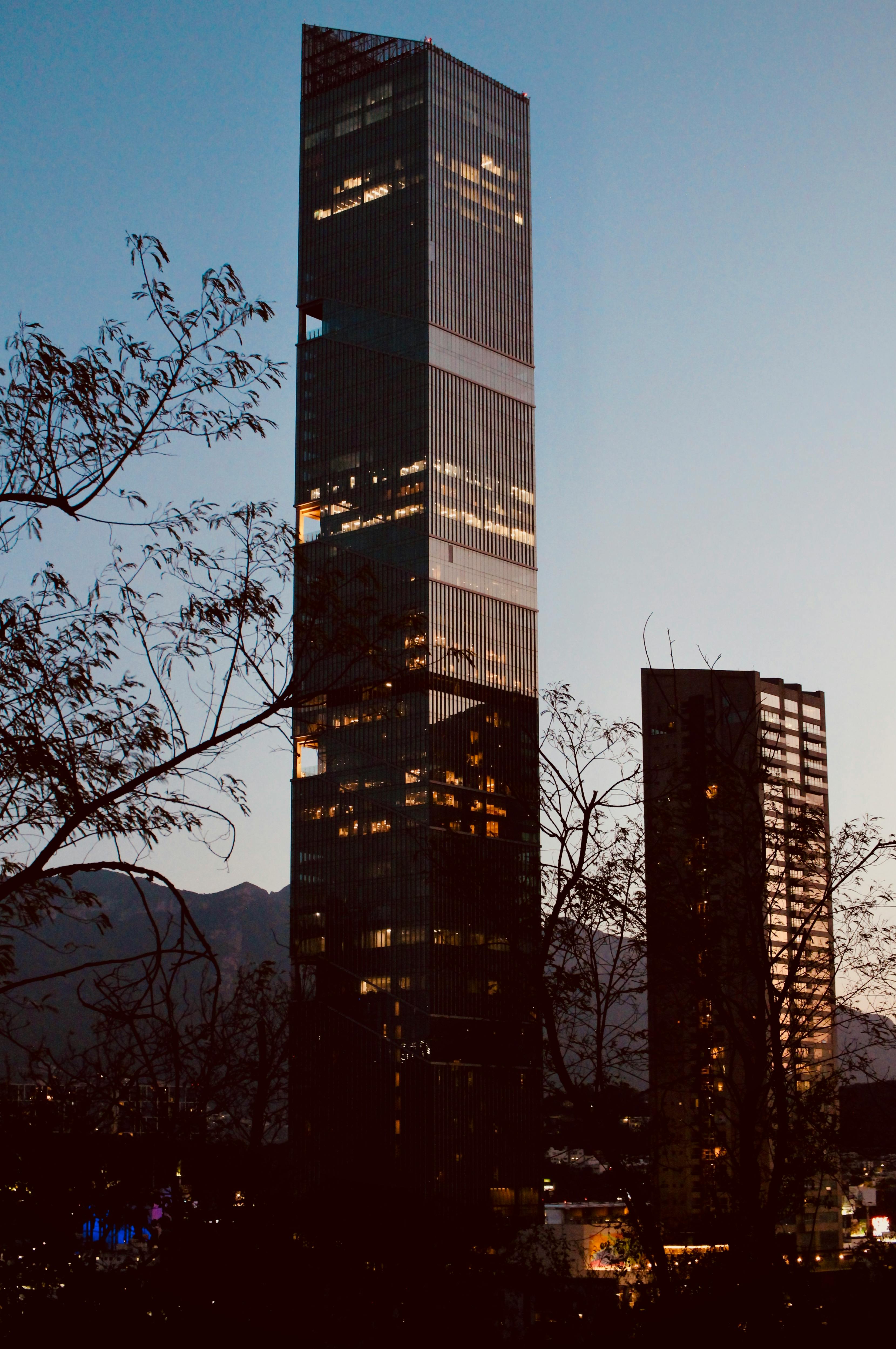
The surprise up here is scale: the flagpole rises 100 meters, about as tall as a 30-story tower, and the cloth itself stretches 50 by 30 meters, big enough to cover a basketball court and still spill over the edges. Wind does half the storytelling for you; you hear the fabric crack, see its shadow slide across the circular plaza, and watch Monterrey spread out below in a hard, bright sweep of concrete, mountains, and haze.
Come near sunset if you can. Afternoon light softens the city’s severity, but the hill never really turns gentle, and that’s the point: this lookout is less a pretty balcony than a civic stage where Monterrey shows off its size, its weather, and its appetite for monumentality.
Palacio del Obispado and the Museum Below the View
Most people charge straight to the flag and miss the older drama one slope below: a palace completed in 1787 for Bishop Fray Rafael José Verger, built from limestone on the rock itself, with thick walls, arcades, and a dome that still changes the air around it. Step inside and the temperature drops, footsteps echo under the oratory, and the place stops behaving like a lookout and starts acting like what it was for long stretches of the 19th century: a fortress, a refuge, a building that kept being forced into new lives.
Look closely at the facade before you go in. INAH notes that the niche of the Virgin still carries shrapnel damage, which means the hill’s military past is not trapped in labels or dates like 1846 and 1864; the violence remains on the skin of the building, visible in stone and plaster if you bother to slow down.
Walk the Hill From the Palace to the Flag
Do this as a sequence, not two separate stops. Start at the museum, where carved stone, the reused wooden portal from San Andrés, and the cistern courtyard give the hill weight and memory, then walk or drive upward toward the exposed summit where all that mass gives way to sky, glare, benches, gardens, and wind.
That climb changes the place. You begin with a bishop’s retreat built during hardship after a late frost, pass through a building that served wars, epidemics, and even a 1920 cabaret, and end under a flag inaugurated on February 24, 2005, as if Monterrey decided the best answer to history was to plant a 250-kilogram sheet of fabric over the whole argument.
Plan and listen to Mirador Del Obispado with Audiala
Audio guide in your pocket, itinerary in your browser. Built for the way you actually visit.
03 Visitor logistics.
The practical scaffolding for a good visit — kept short.
Getting There
Drive or take a taxi to Rafael José Verger s/n, Obispado, 64060 Monterrey, N.L.; cars can go up the hill, and the main parking lot sits at the park entrance with a smaller upper lot mainly for disabled visitors. As of 2026, the newest transit option is Regio Ruta D to José Benítez y cerrada Padre Mier, then a steep paved walk up Fray Rafael J. Verger; Moovit also lists Fundadores Metro as a transfer point, but expect a longer uphill approach.
Opening Hours
As of 2026, the open-air mirador is officially listed as open daily from 8:00 to 21:30. The adjacent Museo Regional de Nuevo León, El Obispado, is best read as Tuesday to Sunday from 9:00 to 18:00, though one INAH page shows an inconsistent Spanish-hours line, so museum-focused visits are worth confirming in advance.
Time Needed
Give the mirador alone 30 to 45 minutes if you drive near the top, walk the esplanade, and take in the skyline. Add the museum and you are closer to 1.5 to 2 hours; linger for sunset and the full stop stretches to 2.5 or even 3 hours.
Accessibility
The mirador is more promenade than hike: a wide paved path, lighting, benches, toilets, drinking fountains, and vehicle access make it possible for some visitors with limited mobility. Full step-free access is not clearly documented end to end, and the historic museum should not be assumed barrier-free without calling ahead because official pages do not mention elevators or lifts.
Cost & Tickets
As of 2026, entry to the mirador is free, and official parking is MXN 40. The museum next door charges MXN 105 for Mexican nationals and MXN 210 for foreign visitors; Sundays are free for Mexican citizens, and children under 13, students, teachers, and seniors also qualify for free entry under INAH rules.
05 Tips for visitors.
Small things that change the day.
Go Late Afternoon
Monterrey sun hits this hill hard, and the concrete throws heat back at you. Late afternoon gives you kinder light, better photos, and a real shot at seeing the mountains instead of haze.
Do The Museum
Most people come for the 100-meter flagpole and leave with a photo. Stay for the museum: the palace from 1787 is the oldest surviving colonial building in Monterrey, and its oratory holds a 1783 Guadalupan altarpiece that most visitors miss.
Camera Rules
Phone photos and ordinary personal photography are generally fine, but professional shoots at INAH sites need authorization. Drone use is not clearly posted for this hill, so do not assume you can fly here without both aviation compliance and heritage-site permission.
Urban Caution
The usual risk here is not a scam but a careless one: do not leave valuables visible in the car, and be cautious on isolated side streets after dark. Obispado is comfortable by Monterrey standards, though some adjacent pockets feel rougher once you leave the main roads.
Eat Regio Nearby
Skip generic mall food if you can. Nearby options with local credibility include Montecoyote for budget coffee, San Carlos for classic regiomontano dishes like machaca, and El Gran Pastor when you want cabrito without crossing half the city.
Expect An Incline
Rideshares may not always leave you at the very top, which can turn the last stretch into a short uphill walk on pavement. That sounds minor until midday heat and wind hit at once, so plan your drop-off with that in mind.
Where to Eat
Don't Leave Without Trying
Dining Tips
- check Most food options cluster below the mirador—expect a 0.4–0.7 mi walk, so taxis or Uber are convenient.
- check The uphill walk back to the mirador can be tiring, so plan your route accordingly.
Restaurant data powered by Google
04 Historical Context
A Prayer House That Learned to Fight
Mirador del Obispado borrows its name from a building older and more complicated than the lookout around it. Records show the city granted this hill to the bishopric on 2 June 1787, and Bishop Fray Rafael José Verger y Suau began a retreat house here that same year, partly to give work to poor farmers after frost and crop losses had hit the region hard.
That quiet purpose did not last. After Verger’s death in 1790, the palace drifted away from its intended life and became something harsher: a strategic military position during the U.S. invasion of 1846, the French Intervention of 1864, the Revuelta de la Noria in 1871, and the opening phase of the Mexican Revolution in 1913-1914.
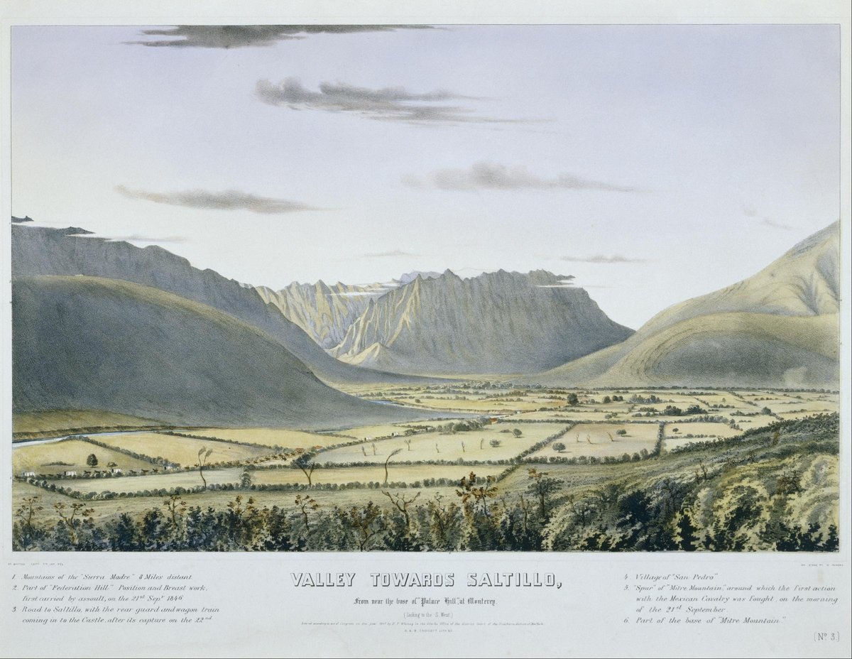
The Hill Taken at Dawn
The most dramatic documented episode came during the Battle of Monterrey on 22 September 1846. Contemporary images and later historical summaries show the western heights falling under U.S. attack, exposing the bishop’s palace and turning this ridge into the key to the city’s military geometry; if you stand here now in evening calm, it takes effort to imagine rifle fire and artillery rolling across the same slope.
From Lazaretto to Cabaret
The palace’s afterlife reads almost like a dare. INAH records show it fell into ruin, served as a lazaretto during epidemics in 1898 and 1903, and was even used as a cabaret in 1920 before restoration campaigns began in the 1940s and the museum opened on 20 September 1956, which means this hill survived by reinvention rather than reverence.
Listen to the full story in the app
06 Frequently asked.
Is Mirador del Obispado worth visiting?
Yes, especially if you want the quickest big-picture view of Monterrey. The summit gives you the city spread below the Sierra Madre, a 100-meter flagpole that reads like a 30-story needle, and easy access by car or taxi. Do the museum too, because the real punch of the place sits in the old bishop's palace beside the viewpoint, where shrapnel still marks the facade.
How long do you need at Mirador del Obispado?
About 30 to 45 minutes works for the mirador alone, and 1.5 to 2 hours makes more sense if you add the museum. Give yourself longer near sunset, when people tend to linger and the city lights start to pull focus. A thorough stop with terraces, galleries, and a slow walk can stretch to 2.5 or 3 hours.
How do I get to Mirador del Obispado from Monterrey?
The easiest route from central Monterrey is by car, taxi, or rideshare up Rafael José Verger s/n in the Obispado district. Public transport also works: current local reporting points to Regio Ruta D, getting off at José Benítez y cerrada Padre Mier, then walking uphill along Fray Rafael J. Verger. Expect the final approach to feel steep, even though it is paved.
What is the best time to visit Mirador del Obispado?
Late afternoon into sunset is the best time for most visitors. The hilltop is exposed, so Monterrey's midday sun can feel punishing on the paving, while winter evenings often bring cleaner air, sharper mountain outlines, and better color. Go earlier in the day if haze or storms are in the forecast and you want the clearest view.
Can you visit Mirador del Obispado for free?
Yes, the mirador itself is free to enter. Parking is listed at MXN 40, while the adjacent Museo Regional de Nuevo León, El Obispado, has a separate ticket with INAH rates and free Sunday admission for Mexican citizens. If you only want the view and the flag, you can do that without paying entry.
What should I not miss at Mirador del Obispado?
Don't stop at the giant flag and leave. The best detail on the hill is next door at the palace facade, where INAH notes the Virgin's niche still carries battle damage from shrapnel, and inside the museum the oratory dome and 1783 Guadalupan altarpiece give the place its older heartbeat. The summit gives you scale; the palace gives you memory.
Researched and written by the Audiala editorial team from historical records, architectural archives, and local expertise.
Historical guide used for the 1787 land grant, construction timeline, and Bishop Verger context.
Essay on the Obispado used for Verger biography, early history, and later reuse of the palace.
Biographical reference for Bishop Fray Rafael José Verger y Suau and his dates.
Summary of the 1846 storming of the Bishop's Palace during the Battle of Monterrey.
Period image reference for the 1846 assault on the palace position.
Visual source showing the palace and heights in U.S. hands on 23 September 1846.
Additional period image reference for the 1846 battle setting.
Official tourism page used for hours, free entry, parking fee, address, dimensions, and flag specifications.
State bulletin used for restoration details and the note about the common name Obispado.
INAH page used for architecture, facade details, shrapnel damage, the reused door, and the oratory.
INAH bulletin used for 2025 restoration works and museum status during repairs.
INAH feature used for historical and architectural framing of the Obispado.
INAH overview page used for general history and unresolved chronology references.
Background article used for alternate construction and dome-completion claims.
INAH history page used for restoration phases and museum opening context.
Local media source used for the tunnel legend and oral tradition.
Article used for myth-versus-fact reporting on the Obispado tunnels.
Local folklore source for ghost stories and oral legend around the site.
Navigation listing used as a secondary check on visitor hours and location.
INAH visitor page used for museum hours, fees, guided visits, and facilities.
Spanish INAH visitor page used to compare museum hours, pricing, and services.
Museum page used for hours, ticketing, guided visits, and gallery information.
Official museum page used for gallery themes and museum significance.
Trail listing used as a cautionary note about stale closure information.
Recent local reporting used for Regio Ruta D access instructions.
Official transit site referenced for Regio Ruta service context.
Transit planning source used for nearby stops, metro links, and bus lines.
Traveler aggregation used for visit duration and access notes.
Listing used for a nearby coffee option.
Secondary listing used to support the nearby café suggestion.
Restaurant chain location page used for nearby dining around Galerías Monterrey.
Hotel dining page used for practical nearby restaurant options.
INAH visitor-rules page used for lockers and museum behavior guidance.
Traveler reviews used for weather, sun exposure, and typical visit experience.
Traveler aggregation used for general photo-spot and access impressions.
Travel listing used for the mirador layout and best-time photo notes.
English museum page used for gallery themes and visitor framing.
Travel reference used for material and museum description details.
Spanish traveler aggregation used for experience notes and timing.
Secondary reference used for view descriptions and civic-event context.
Local report used for winter sunset and visibility observations.
Climate reference used for seasonal weather context and heat exposure.
Museum virtual tour page used to note remote visit options.
Cultural venue listing used for nearby programming below the hill.
Local discussion used for how residents refer to El Obispado.
Local discussion used for common names and local perception of the site.
Local comments used for everyday social use of the mirador.
Local chatter used for recent attitudes about closures and reopening.
Local report used for the mirador's role as a meeting point.
Coverage used for patriotic-date use of the mirador.
News item used for civic-ceremony context tied to the flag.
Report used for military and Flag Day ceremonies at the site.
Travel source used for civic-event and viewpoint framing.
Cultural directory used for Concha Acústica venue context.
Local reporting used for neighborhood character, traffic, and daily urban context.
Local report used for general neighborhood safety context.
Resident discussion used for safety and neighborhood impressions.
Local comments used for safety and walkability context.
Resident discussion used for neighborhood feel and local distinctions.
Local food guide used for nearby cabrito context.
Directory used for nearby restaurant suggestions and machaca note.
Food writing used for broader regiomontano culinary context near the area.
Local discussion used for food suggestions around Monterrey.
News report used for October 2025 restoration completion.
Local discussion used for 2025 access and closure chatter.
Local discussion used for rumors and pushback about the site's status.
Report used for heritage-pressure context in the Obispado area.
Local report used for neighborhood development controversy context.
News source used for haze and air-quality caution affecting views.
INAH statement used for personal photography rules at heritage sites.
Official permit information used for professional photo and video authorization.
Alternate INAH permit page used for commercial imaging authorization details.
National aviation guidance used for drone-regulation context.
Local thread used as evidence that drone rules are not obvious to visitors.
Local discussion used for ordinary urban-safety cautions.
Listing used for a nearby specialty coffee option.
Restaurant listing used for a nearby casual meal option.
Restaurant listing used for an easy nearby meal option.
Listing used for a nearby casual dining option.
Restaurant listing used for an upscale nearby dining option.
Last reviewed