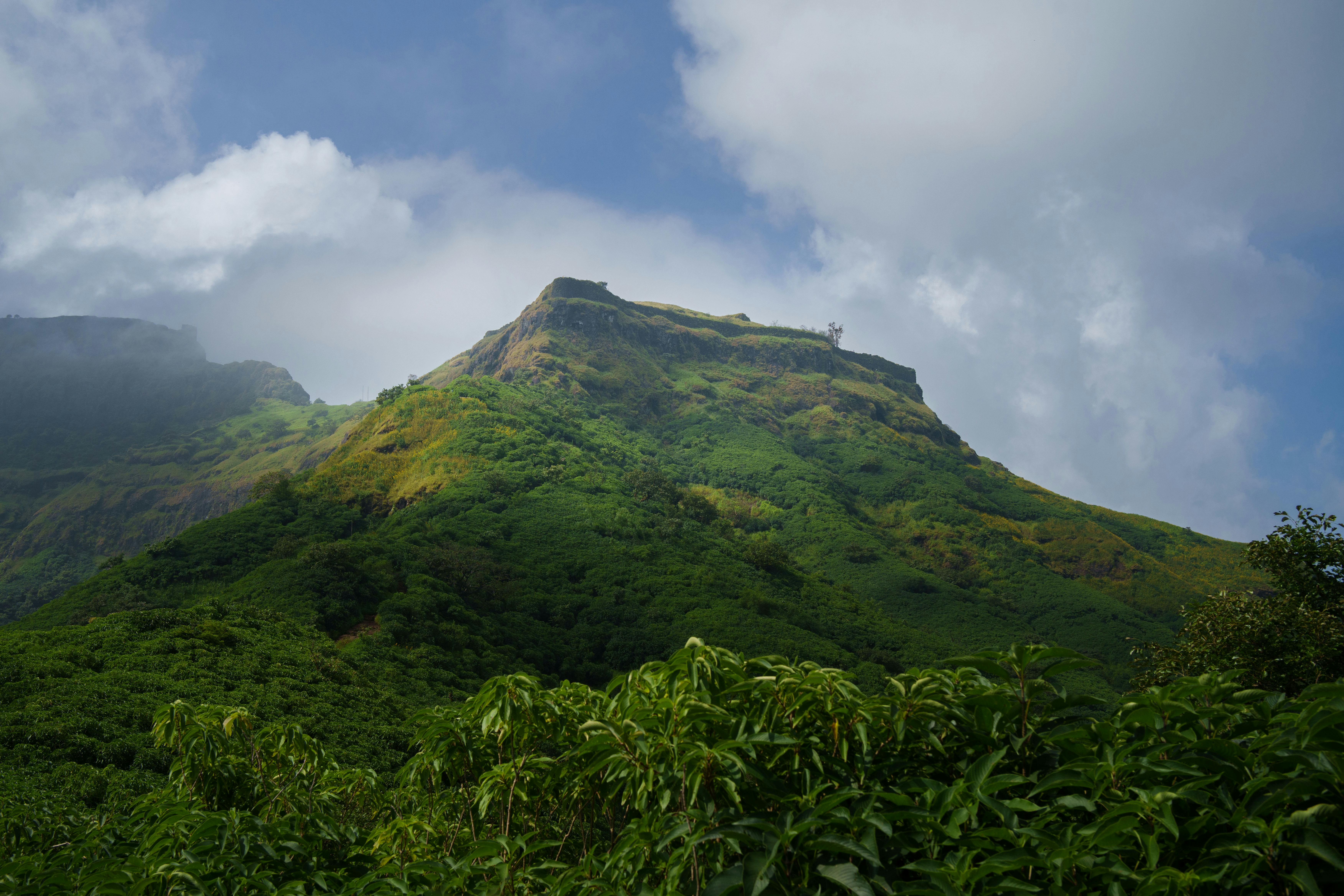
FFrom Palghar's railway corridor, a flat-topped slab of dark rock interrupts the Western Ghats skyline like a table no one bothered to clear. That silhouette belongs to Kaldurg Fort, perched roughly 475 meters above sea level in Maharashtra's Palghar district, India — a fort so stripped of its own masonry that first-time visitors sometimes wonder if they've reached the right hill. They have.
Kaldurg was never a palace or a grand citadel. Local fort historians classify it as a watch fort — an observation post guarding the Chahad pass below, its value measured not in walls but in sightlines. On a clear day the summit delivers views west to the Arabian Sea and east across the Surya River valley, from a rectangular platform roughly the size of a basketball court.
The climb passes through dense forest that hides the fort until you're nearly underneath it. Monkeys patrol the Waghoba temple at the base, indifferent to trekkers. The ascent is steep but short — under ninety minutes for most — and what waits at the top is less a ruin than a geological stage set: rock-cut cisterns, scattered stone fragments, and a silence that feels earned.
01 What to See
The Upper Citadel and Rock-Cut Cisterns

The Meghoba Temple Fragments
The Summit Panorama

Plan and listen to Kaldurg Fort with Audiala
Audio guide in your pocket, itinerary in your browser. Built for the way you actually visit.
03 Visitor logistics.
The practical scaffolding for a good visit — kept short.
Getting There
Palghar station sits on Mumbai's Western Railway line — about 2.5 hours from Churchgate on a slow train, under 2 hours if you catch a fast one. From Palghar town, the trailhead near Waghoba temple is roughly 8 km east by auto-rickshaw or private car. No public bus runs directly to the base, so arrange your ride back before you start climbing.
Opening Hours
Kaldurg is an open ruin with no gates, no ticket booth, and no official hours. As of 2026, you can walk up any time — but the trail threads through dense forest with no lighting, so plan to finish well before sunset. The monsoon months (June through September) make the climb slippery and visibility poor; most trekkers avoid July and August entirely.
Time Needed
The climb from the Waghoba temple area takes 45 minutes to an hour at a moderate pace. Budget another 30–45 minutes on top to explore the two levels, the rock-cut cisterns, and the Meghoba temple ruins. Round trip, including time to sit on the summit and absorb the views toward the Arabian Sea, plan on 2.5 to 3 hours.
Accessibility
This fort is not accessible to wheelchairs or anyone with limited mobility. The final approach involves 8–10 rock-cut steps carved into bare stone, and the trail itself is an uneven forest path with no railings or paved sections. The upper citadel requires some light scrambling over exposed rock.
05 Tips for visitors.
Small things that change the day.
Watch the Monkeys
The Waghoba temple at the base is known for its resident troop of monkeys. Keep food sealed and bags zipped — they're bold enough to snatch anything visible from an open backpack.
Go October to February
Post-monsoon months give you the best combination: the forest is still green, the cisterns hold water, and the air is clear enough to spot the Arabian Sea from the summit. Start by 7 a.m. to avoid the midday heat and catch the low-angle light that makes the rectangular rock profile look its sharpest.
Carry All Your Water
The rock-cut cisterns on top were deliberately destroyed by colonial authorities back in 1862. No reliable water source exists on the fort or along the trail. Bring at least 2 liters per person — there's nowhere to refill.
Find the Flag Socket
On the upper citadel, look for a large circular hole cut into the rock near the edge — likely a flagstaff base. Nearby, square post-holes line the rim where temporary guard shelters once stood. These are easy to miss if you're only scanning for walls, because Kaldurg was built more from subtraction than addition: carved into rock rather than stacked from stone.
Summit Panorama Angles
The western edge delivers the widest view — Palghar town, the Surya River, and on clear winter mornings, the Arabian Sea glinting about 25 km away. The fort's flat rectangular top (distinctive enough to spot from moving trains below) also makes a natural frame if you photograph east toward the Sahyadri ridgeline.
04 Historical Context
The Fort They Tried to Kill
Kaldurg's documentation is thin. Unlike Maharashtra's famous hill forts — Raigad, Pratapgad, Sinhagad — this one left almost no paper trail. What survives comes from a 19th-century colonial gazetteer and the careful fieldwork of modern Marathi fort researchers who piece together its story from rock cuttings, temple fragments, and oral tradition.
The fort sits above the Chahad pass, a route connecting the Konkan coast to the interior. Controlling that pass meant controlling trade and troop movement through North Konkan. For a structure with almost no remaining walls, Kaldurg occupied a disproportionately strategic position.
The Year They Drained the Rock
In 1862, the Bombay Presidency Gazetteer recorded Kaldurg as already ruined — then the authorities went further. Concerned that intact water cisterns could shelter outlaws, they ordered the fort's water supply destroyed: deliberate architectural euthanasia, ensuring no one could garrison the hilltop again. The rock-cut tanks that survive today are the ones they missed.
A Fort by Other Names
The Marathi fort research collective Durgbharari records that Kaldurg was also known as Kalmegh and Nandimal at different points in its history. The name shifts suggest different rulers renaming the site — a common pattern in Maharashtra, where forts accumulated names the way European castles accumulated coats of arms. The Meghoba temple area on the summit, with its broken Shivlings and damaged Nandi idol, may connect to the Kalmegh name, though no source confirms the link.
Listen to the full story in the app
06 Frequently asked.
Is Kaldurg Fort worth visiting?
Worth it if you want a quiet hillfort with genuine views and no crowds — less so if you expect standing walls or grand architecture. The fort has almost no intact masonry; local trekkers describe it bluntly as a place that barely looks like a fort. What it delivers instead is a wide summit with views stretching to the Arabian Sea on clear days, forest cover that keeps the approach cool, and the odd satisfaction of standing somewhere the British colonial administration once considered dangerous enough to sabotage.
How long do you need at Kaldurg Fort?
Allow 2 to 3 hours for the full experience — roughly 45 to 60 minutes up through dense forest, time to explore the two-level summit, and the descent back. The summit itself won't hold you more than 30 to 40 minutes unless you linger over the views or examine the rock-cut cisterns and the ruined Meghoba temple area carefully.
How difficult is the Kaldurg Fort trek?
Moderate — a steady forest trail with no technical climbing required. The path rises to about 475 m above sea level, roughly the height of a 160-storey building, and ends with a short flight of 8 to 10 rock-cut steps near the upper citadel. Decent footwear and water are enough; no guide is strictly necessary, but the trail isn't well-marked.
What is the history of Kaldurg Fort?
The fort's documented history is thinner than its reputation suggests. By 1862, the Bombay Presidency Gazetteer already described it as a ruin, and British authorities that year deliberately destroyed its water supply to prevent outlaws from using it as a base. Local fort researchers trace earlier control to the Bimb rulers of Mahim, then the Portuguese, and finally the Marathas during the Vasai campaign of 1737–1739 — though these earlier periods rest on local historical tradition rather than verified primary documents.
What can you see from the top of Kaldurg Fort?
On a clear day the summit opens to Palghar town to the west, the Arabian Sea beyond it, the Surya River valley, and the silhouettes of nearby forts. The fort's flat rectangular top — distinctive enough to spot from the Palghar rail corridor — makes it a natural viewpoint across the North Konkan hill belt.
What is the best time to visit Kaldurg Fort?
October through February, after the monsoon clears and before the summer heat builds. The trail stays shaded by dense forest, but the open approaches bake from March onward. Avoid June through September unless you're experienced with monsoon trekking — the rock-cut steps and upper surfaces get genuinely slippery.
Is there an entry fee for Kaldurg Fort?
No entry fee. Kaldurg is an open archaeological site on government land with no ticketing or staffing. Bring your own water — the four cisterns on the fort (one on the lower plateau, three on the upper level) are dry.
Researched and written by the Audiala editorial team from historical records, architectural archives, and local expertise.
Official district tourism entry, updated January 2026. Architecture details, elevation estimate, and description of the fort's distinctive rectangular top.
Primary near-contemporary historical source. Documents the fort as a ruin by 1862 and records the British decision to destroy its water supply. Elevation given as 1,547 ft.
Most detailed on-site description available. Lists architectural features including cisterns, rock-cut steps, post-holes, flagstaff socket, and Meghoba temple remains. Provides alternative historical names (Kalmegh, Nandimal) and an ownership timeline.
Coordinates (19.6913 N, 72.8170 E) and elevation data for Kaldurg Fort.
Trek difficulty, approach details, and characterisation of Kaldurg as a watch post rather than a major built stronghold.
Maharashtra tourism description confirming the fort's watchtower function and basic visitor context.
Last reviewed