Type 2+ letters to search all countries, cities, and places
/Ctrl KEsc
travel_explore
Type 2+ letters to search all countries, cities, and places
Press Enter to open the top result
Berliner Balkon
Berlin·Germany·52° N · 13° E·Updated Apr 2026
Berlin's only visible Ice Age escarpment: a 15m glacial drop found nowhere else in the city, leading to a DDR-era queer resistance story in a Victorian museum.
Paved frost-resistant path to main viewpoint; natural terrain beyond
Best season
Spring (April–May) or Autumn
The highest point of the Berliner Balkon — the exact ridge where a post mill turned in the wind from 1808 to 1936 — now sits beside a recycling depot. This is the only place in Berlin, Germany, where the Barnim plateau's edge falls visibly into the ancient glacial valley below, a 15-metre drop that locals in Kaulsdorf and Mahlsdorf nicknamed the "Berlin Balcony" because standing here feels exactly like that. Come for the view east toward Brandenburg. Stay because almost no tourist ever does.
The Balkon is not a monument. It's a natural escarpment shaped by a Nordic glacier about 12,000 years ago, then quietly farmed, windmilled, bombed over, paved with a €900,000 EU-funded concrete path in 2004, and declared a landscape protection area in August 2012. Twenty-five hectares. Free, open always, unsupervised.
You reach it from the far eastern edge of the city, well past where most visitors stop. The reward is a horizon line Berlin otherwise refuses to give you — flat, enormous, agricultural, with the federal B1/B5 humming along the ridge above and the Kaulsdorfer Seen glinting somewhere to the south.
This guide treats the Balkon as what it actually is — a slice of Ice Age geology with 20th-century scars still showing, and a neighbourhood that keeps rebuilding its own benches when the district runs out of budget.
Researched by the Audiala editorial team from historical records, architectural archives, and local expertise.
What to see
The Edge Itself — 15 Metres of Ice Age
Walk to the rim where the Barnim plateau quits. Fifteen metres down — roughly a four-storey building — the ground falls into the Warschau-Berliner Urstromtal, a glacial outwash valley carved 12,000 years ago when a Nordic ice sheet dumped its last load of till here and retreated north. This is the only place in Berlin where you see that drop undeveloped, unbuilt, raw.
From the central viewpoint at the top of the Gloritbeton path, three glacial lakes glint in the floor below: Butzer See, Habermannsee, Elsensee. On clear mornings the Müggelberge rise 8 kilometres southeast, their 30-metre watchtower poking the horizon at 114 metres. Köpenick's towers stack up in the middle distance.
The sensation is specific. Wind catches you differently on the rim than in the sheltered valley — you feel the escarpment as weather, not just geography. Skylarks in summer. Nightingales in spring. No traffic noise, because there's no traffic to make any.
The Windmill Ghosts and the Teenagers' Benches
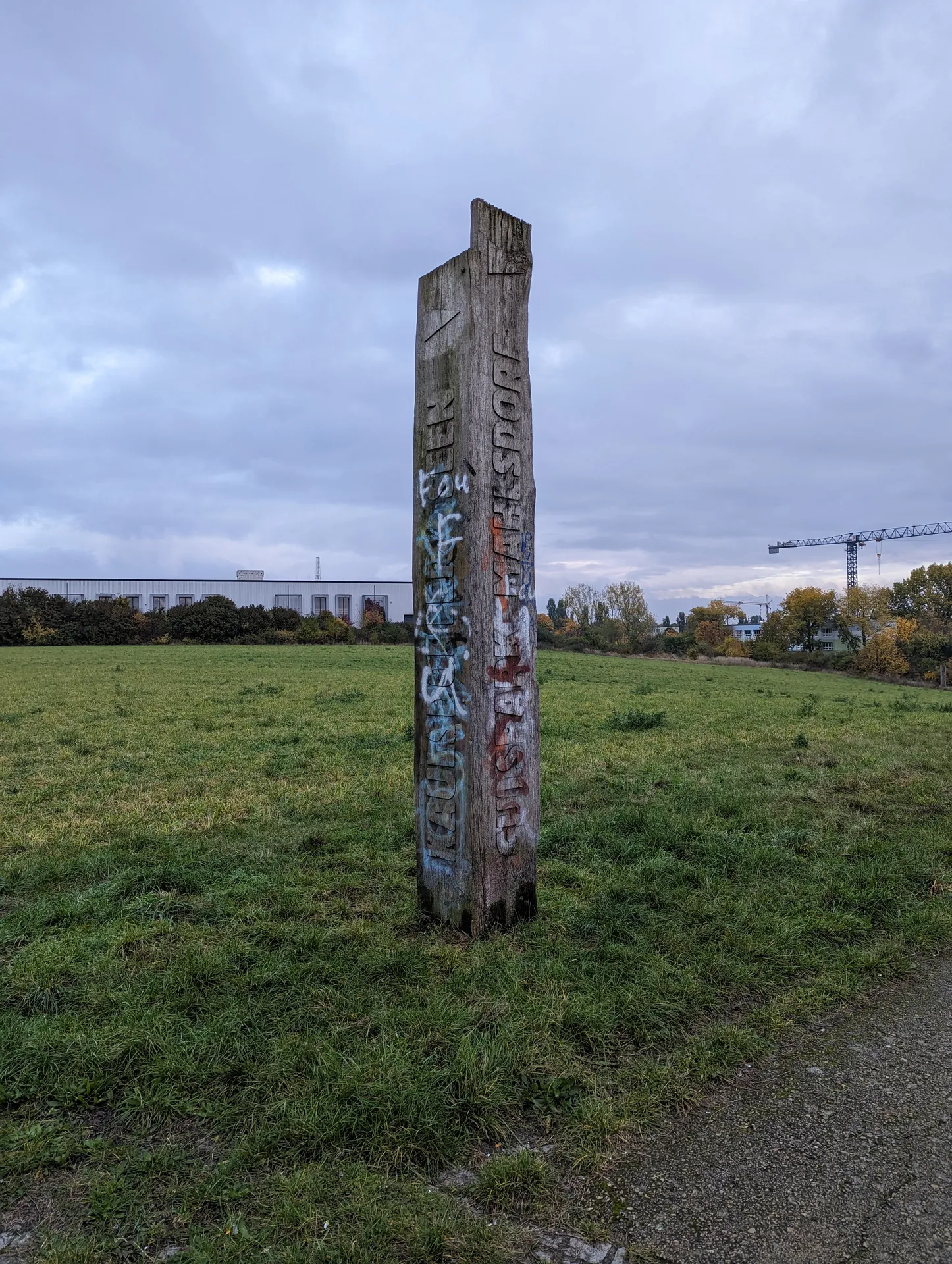
On the highest point of the slope, a Bockwindmühle — a post mill whose entire body rotated on a central wooden trestle to face the wind — stood from 1808 to 1936, when the district tore it down as an eyesore. What remains is a wooden artwork: four stelae, oversized gear-wheel fragments, chair-scale seating, all meant to collapse 12,000 years of geology and 228 years of milling into one viewing platform.
Vandals got to it. Repeatedly. The district authority removed the most damaged steles on safety grounds, ruled out reinstallation in 2022 for budget reasons, and the sculpture group sits diminished. Then five teenagers from Mahlsdorf showed up with timber and concrete, built three new benches, and bolted them in along the rim.
Sit on one. The slope in front of you is active farmland — grain and clover rotating through the seasons on a protected 25-hectare conservation zone granted Landschaftsschutzgebiet status in August 2012. Autumn strips the fields and exposes the raw moraine contours most clearly.
The Grüne Runde Loop — Balcony, Lakes, Gründerzeit
Do it as a circuit. Start at Mahlsdorf S-Bahn (S5, 850 metres from the rim), walk the Gloritbeton path to the central viewpoint — the €900,000 EU-funded concrete is frost-resistant and wheelchair-accessible, an engineering concession laid across raw glacial till in 2004. Descend the escarpment face, looking back up at the moraine material you were just standing on.
Follow the path into the Kaulsdorfer Seen conservation area. Habermannsee is a drinking-water protection zone, so no swimming. Elsensee is privately owned, 13.3 hectares, 14.5 metres deep, dug out of sand extraction between 1968 and 1995 and now passing convincingly for a natural lake.
Loop back through Gutspark Mahlsdorf — 18 hectares of landscape park, originally an orchard, redesigned in 1892, restored 1993–95 — and end at the Gründerzeitmuseum, which documents the Wilhelminian decades when the windmill above still turned. The whole thing is roughly three hours at a photographer's pace. Bring water; there's no café on the rim.
Plan your visit
Getting There
Take S-Bahn S5 to S Mahlsdorf, then walk about 10 minutes up Alt-Mahlsdorf (B1/5) to the entry opposite Neuenhagener Straße. Faster option: bus 195 or 269 to Kressenweg stop, then a 5-minute walk up to the central viewpoint. By car, follow B1/5 and turn at the Garni Hotel 'An der Weide' into the small informal parking area.
Opening Hours
Open 24/7, year-round, with no gates, no staff, and no seasonal closure. As of 2026, entry remains completely free. Paths stay passable in winter but the Gloritbeton surface gets slick after frost or heavy rain.
Time Needed
Viewpoint-only stop: 20–30 minutes. Loop walk to Butzer See: roughly 2 hours over 7–9 km of easy-to-moderate terrain. Full green route combining the Balkon, Kaulsdorfer Seen, and Gründerzeitmuseum runs about 1h45 of walking (9.8 km) — plan a half-day if you add the museum visit.
Accessibility
The ~25-hectare path network is officially barrier-free, paved with frost-resistant Gloritbeton laid in the €900,000 EU project of 2004. The 15-metre gradient is gentle via the paths, not a scramble. No railing guards the main viewpoint — keep small children and wheelchair users back from the edge.
Cost
Free, always. No tickets, no booking, no audio guide fee. If you pair with the Gründerzeitmuseum Mahlsdorf down the road, that's the only paid stop on the route (Wed and Sun opening only, so check before you come).
Photo Gallery
Three weathered wooden pillars stand beside a curving paved path at Berliner Balkon in Germany. The open field and clear daylight give the site a stark, spacious character. · Angela M. Arnold (44 penguins)A broad, sunlit field stretches across Berliner Balkon in Germany beneath a clear blue sky. Bare branches frame the foreground, while a few distant houses line the horizon. · Angela M. Arnold (44 penguins)A weathered wooden marker stands in the open grassland of Berliner Balkon in Berlin, Germany. Cloudy light, low industrial buildings, and a construction crane give the scene a stark edge. · MolgreenBerliner Balkon opens onto wide green fields and a quiet Berlin skyline under a heavy, shifting sky. A cobblestone path, wooden bench, and open horizon give the lookout its calm edge-of-city feel. · Molgreen
History
The Ridge That Remembers
Records show the Bockwindmühle stood on the summit from 1808 to 1936 — 128 years of grinding grain for Mahlsdorf and Kaulsdorf before it came down. No surviving archive names the builder. The 1808 date itself sits in local histories without a primary citation, so treat it as attributed rather than documented.
Everything else about this slope is written in a heavier hand. The federal road along the ridge — today's B1/B5 — is the old Reichsstraße 1, a route Napoleon marched, the Wehrmacht rolled out along, and the Red Army rolled back down. The Balkon watched all of it from below.
The turning point
Charlotte von Mahlsdorf and the Rolling Pin
Seven hundred metres from the Balkon viewpoint, on Alt-Mahlsdorf, Lothar Berfelde was born on 18 March 1928 into a house ruled by terror. Her father Max — NSDAP member since the late 1920s, local political leader in Mahlsdorf — beat his family and pushed Lothar into the Hitler Youth at fourteen. In 1944, with the mother gone and the war closing in, Max held a service revolver to his child and demanded a choice.
Lothar killed him in his sleep with a rolling pin. She was sixteen. A Berlin court convicted her in January 1945 as an "asozialer Jugendlicher" — four years in juvenile prison, cut short by the regime's collapse weeks later.
She became Charlotte von Mahlsdorf, opened the Gründerzeitmuseum in 1960 in the Gutshaus down the road, sheltered one of the GDR's earliest gay support groups (HIB) in the basement from 1973, and — according to post-reunification Stasi files — filed reports on those same gatherings as IM Vera. She claimed coercion; scholars still argue. She died 30 April 2002. Doug Wright won a Pulitzer writing her as I Am My Own Wife. Walk the Balkon and then walk to the museum. The two places explain each other.
12,000 Years in the Mud
A Nordic glacier dumped the moraine that forms this ridge at the end of the last Ice Age. The Barnim plateau runs east from here all the way to the Oderbruch — an elevated shelf of glacial till (Geschiebemergel) that ends, abruptly and visibly, right where you're standing. Below lies the Warschau-Berliner Urstromtal, the ancient glacial outwash channel that cradles central Berlin and the Spree. It's the only place in the city where that geological break is still legible above ground, undeveloped by accident rather than design. Farmers still work parts of the protected area. The concrete path laid in 2004 runs from Kressenweg/Elsenstraße to the windmill viewpoint in frost-resistant Gloritbeton — a product chosen because this ridge freezes hard.
April 22, 1945
Eighty-one years ago today, the 1st Byelorussian Front pushed west along the ridge road above this slope. Soviet tank columns on the old Reichsstraße 1, smoke from the previous days' bombing, and — per a contemporary account preserved in district history — the dead lying "like sand on the beach" in the village street. Just south of the Balkon, at Kaulsdorfer Straße 90, a Reichsbahn forced-labour camp held up to 1,400 Russian and Ukrainian workers, women and children among them, in wooden barracks mostly destroyed by an air raid in winter 1943–44. The Red Army liberated them on 23 April, one day after reaching this ridge. A 2024 report logged 1,068,240 pieces of ordnance eventually pulled from the broader district — 22 aerial bombs, 112 mines, 54,819 grenades. The quiet here is recent.
Tips for visitors
Drones grounded
The slope became Landschaftsschutzgebiet Barnimhang in August 2012, and Berlin's conservation rules generally ban drone flight over such areas. Fly elsewhere unless you've cleared it with the Bezirksamt Marzahn-Hellersdorf.
Go for clear light
Spring mornings and autumn afternoons give the best view toward the Müggelberge in Köpenick — the payoff is horizon distance, not lushness. Skip foggy or overcast days; the whole point is being able to read the glacial valley stretching west.
Eat on Hönower Straße
Nothing on-site, not even a kiosk. Walk into Mahlsdorf afterwards for Café Kunst & Krümel or Café Mahlsdorf (budget, Hönower Str. 65), or Trattoria La Stalla for a mid-range Italian sit-down.
Chain the whole loop
Don't treat the Balkon as a standalone stop. Link it with the Kaulsdorfer Seen lakes and the Gründerzeitmuseum at Gutshaus Mahlsdorf (Hultschiner Damm 333) — Charlotte von Mahlsdorf's Victorian-furniture house, where the basement functioned as an underground queer gathering space in DDR East Berlin.
No toilets on site
Zero facilities across the entire 25-hectare area. Use cafés in Mahlsdorf centre before or after, or the Klinikum Kaulsdorf hospital a few bus stops away.
Dogs on leash
Berlin-wide leash rule applies, and this is a protected landscape zone — stay on paths and keep the dog close. Meadows on either side of the ridge are active agricultural land, not off-leash romping ground.
Calibrate expectations
It's a 15-metre escarpment, not a cliff. Come for the geological oddity — the only visible break between the Barnim plateau and the Warsaw-Berlin glacial valley anywhere in the city — not for Alpine drama.
Where to Eat
local_dining
Don't Leave Without Trying
Currywurst — grilled pork sausage with curried ketchup sauceDöner Kebab — Turkish street-food staple since the 1970s; Berlin's version is canonicalEisbein — cured pork knuckle with sauerkraut and mushy peasKönigsberger Klopse — veal meatballs in creamy caper sauceBerliner Pfannkuchen — jam-filled doughnuts in every bakeryBerliner Weiße — sour wheat beer, served with raspberry (Himbeer) or woodruff (Waldmeister) syrup
Schnitzelei Mitte
local favorite
German Traditional€€star4.5(7274)
Order: Schnitzel vom Kalb (veal schnitzel) with potato salad is the signature—hearty, perfectly executed, unpretentious. Vegan options include outstanding mushroom schnitzel.
Berlin institution (7,274 reviews) beloved by locals for generous portions done right; complimentary welcome beer and welcoming staff make it feel like a neighbourhood gem.
Order: Sweetbreads are executed with remarkable precision; brunch is legendary—sourdough bread, avocado spread, French toast with tiramisu cream.
Highly acclaimed neighbourhood spot with international dishes cooked to exacting standards; brunch is packed, so reserve ahead. Modern Berlin energy without pretension.
checkPayment: Visa/Mastercard at mid-range and upscale spots; EC/Girocard (German debit) is local standard. €10 minimum for cards at some places.
Food districts:Kreuzberg — most culinarily diverse district; Turkish döner heartland; Markthalle Neun Street Food Thursday (17:00–22:00)Prenzlauer Berg — trendy, family-friendly; third-wave coffee, organic bistros; Kollwitzplatz Ökomarkt Thursdays (12:00–19:00)Neukölln — increasingly hip, multicultural; Middle Eastern, Vietnamese, Korean at local prices; Maybachufer Turkish Market Tue/Fri (11:00–18:30)Friedrichshain — riverside dining and creative food scene along the Spree
Restaurant data powered by Google
Frequently asked
Is Berliner Balkon worth visiting?
Yes, if you want a Berlin most tourists never see. It's the only spot in the city where the Barnim plateau's Ice Age edge drops visibly into the glacial valley below — 15 metres of raw geology inside an otherwise flat capital. Pair it with the Gründerzeitmuseum down the road and you get geology, DDR queer history, and three lakes in one afternoon.
How do I get to Berliner Balkon from Berlin city centre?
Take the S-Bahn S5 to Mahlsdorf (roughly 25 minutes from Alexanderplatz), then walk about 10 minutes up Alt-Mahlsdorf to the viewpoint. Alternatively, U5 to Kaulsdorf-Nord then bus 269 to the Kressenweg stop, which leaves you a 5-minute walk from the northern entry path.
How long do you need at Berliner Balkon?
Twenty to thirty minutes for the viewpoint alone. Budget 1h45 to 2h15 for the full loop combining the Balkon, Butzer See and Kaulsdorfer Seen (7–9 km, easy terrain). Add another 1–2 hours if you include the Gründerzeitmuseum on Hultschiner Damm.
Can you visit Berliner Balkon for free?
Yes, completely free, 24/7, no tickets, no staff, no gates. It's a public landscape protection area (Landschaftsschutzgebiet Barnimhang since August 2012) with a barrier-free Gloritbeton path built in 2004 for around €900,000 in EU funding.
What is the best time to visit Berliner Balkon?
Autumn for the light and air — clear days reveal the Müggelberge hills on the southeastern horizon and the slope's farm contours after harvest. Spring brings nightingales and skylarks plus emerging crops; winter strips the fields bare and exposes the raw glacial geology most clearly. Avoid after heavy rain when the Gloritbeton gets slippery.
What should I not miss at Berliner Balkon?
The central viewpoint with its wooden gear-wheel sculpture marking the Bockwindmühle that stood here 1808–1936. Walk the full descent path to see the escarpment face from below, then continue 700m south to the Gründerzeitmuseum — Charlotte von Mahlsdorf's 17-room museum, which doubled as an underground queer meeting place in DDR East Berlin. End at Café Kunst & Krümel on Hönower Straße.
Are there toilets or cafes at Berliner Balkon?
No. Nothing on site — no WC, no kiosk, no staff. Nearest options sit about 10–15 minutes away in Mahlsdorf: Café Mahlsdorf and Café Kunst & Krümel on Hönower Straße 65, or the Klinikum Kaulsdorf hospital for reliable toilets.
Is Berliner Balkon accessible for wheelchairs?
Mostly yes. The main path is paved with frost-resistant Gloritbeton and described as barrier-free by the district; the 15m elevation is handled by gentle gradients, not stairs. Note there's no railing at the main viewpoint, and the informal parking area off the B1/B5 near Hotel An der Weide is small.
Sources & attribution50
Researched and written by the Audiala editorial team from historical records, architectural archives, and local expertise. Last updated April 2026.
Berliner Balkon — German Wikipedia — Geological origin, 1808–1936 windmill dates, Landschaftsschutzgebiet designation August 2012, Gloritbeton path 2004
Berlin Balkon (02) Mahlsdorf 2012-03-06 AMA fec — Angela M. Arnold (44 penguins) — CC BY-SA 2.0 (https://creativecommons.org/licenses/by-sa/2.0/) — Source: https://commons.wikimedia.org/wiki/File:Berlin_Balkon_(02)_Mahlsdorf_2012-03-06_AMA_fec.JPG
Berlin Balkon (01) Mahlsdorf 2012-03-06 ama fec — Angela M. Arnold (44 penguins) — CC BY-SA 2.0 (https://creativecommons.org/licenses/by-sa/2.0/) — Source: https://commons.wikimedia.org/wiki/File:Berlin_Balkon_(01)_Mahlsdorf_2012-03-06_ama_fec.JPG
Strictly necessary cookies keep the site working. Analytics (PostHog, Google Analytics) measures how each visitor uses our pages. Marketing loads YouTube videos and walking-route maps without a tap and lets Google Analytics set advertising cookies. We never sell your data. You can change this any time from the footer.
Privacy
Cookie preferences
Pick what you're okay with. You can change this any time from the footer.
Strictly necessary
Always on
Sign-in, language, navigation. Always on.
Product analytics
PostHog (EU) and Google Analytics record which pages you view and how you use them, under a random identifier stored in your browser. Helps us see which pages work and which need fixing. Google's ad personalisation stays off. No selling.
Marketing
Loads YouTube videos and the walking-route maps (OpenFreeMap) without a tap; without it, they load only when you tap them. If analytics is also on, Google Analytics may set advertising cookies. Ad personalisation stays off.