An introduction.
Researched by the Audiala editorial team from historical records, architectural archives, and local expertise.
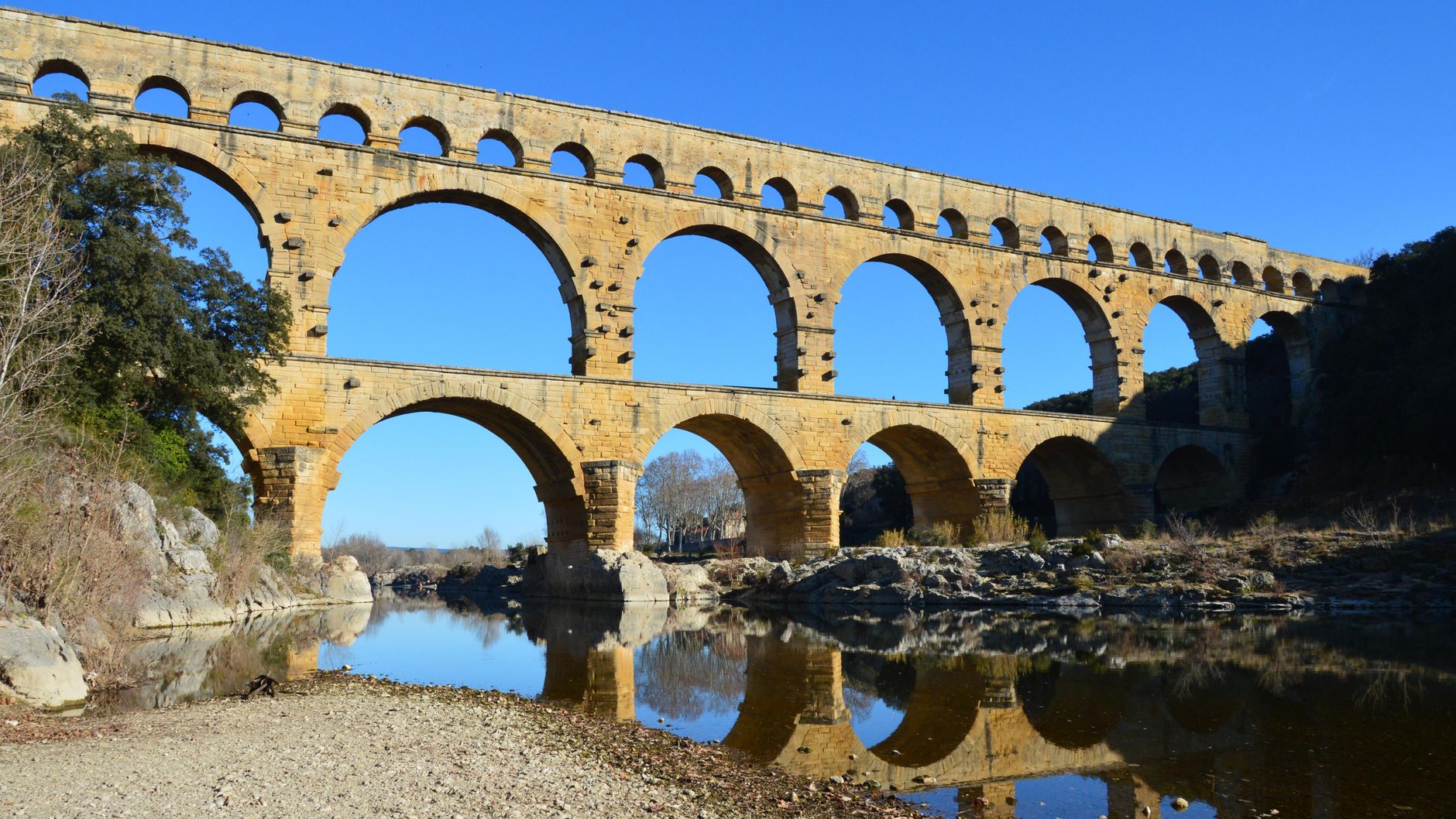
EEvery drop of water that reached the Roman city of Nîmes traveled for nearly 27 hours through 50 kilometers of stone channel — and the most spectacular stretch of that invisible river stands right here, three tiers high above the Gardon valley. The Pont du Gard, near the village of Vers-Pont-du-Gard in southern France, is the tallest aqueduct bridge the Romans ever built, and two thousand years later it still looks like it could carry water tomorrow. Come for the engineering. Stay for the way late-afternoon light turns 50,000 tonnes of limestone the color of warm honey.
The numbers alone are staggering: 48.8 meters tall — roughly the height of a 16-story building — with three stacked arcades of 6, 11, and 35 arches respectively. The massive blocks of the lower tiers, some weighing 6 tonnes, were fitted without mortar. You can still see the projecting bosses the Roman builders left on the stone faces, originally used to grip the blocks with ropes and pulleys, never trimmed off because nobody expected tourists.
But what makes the Pont du Gard more than an engineering curiosity is its setting. The Gardon River curls beneath the lowest arches, shallow enough to wade in summer, flanked by scrubby Mediterranean garrigue that smells of thyme and hot dust. Kayakers pass underneath. Swimmers lounge on the pale gravel banks. The UNESCO World Heritage designation, granted in 1985, protects the structure and the surrounding landscape, but the place has never felt like a museum.
Vers-Pont-du-Gard itself is a quiet Provençal village, more a staging post than a destination. The real draw is the bridge and the 165-hectare cultural site around it, which includes a museum, walking trails through the old Roman quarry at L'Estel, and enough shade to survive a July afternoon. Plan for at least half a day — the kind of half-day that quietly becomes a full one.
01 What to see.
The Three-Tiered Aqueduct Bridge
The Third-Level Water Channel (Guided Tour Only)
The Mémoires de Garrigue Trail & Roman Quarry
02 In pictures.


Plan and listen to Pont du Gard with Audiala.
Audio guide in your pocket, itinerary in your browser. Built for the way you actually visit.
03 Visitor logistics.
The practical scaffolding for a good visit — kept short.
Getting There
By car, take the A9 motorway to exit 23 (Remoulins), then follow the RN100 toward Uzès — it's 27 km from Nîmes, 21 km from Avignon. By bus, Line 121 from Nîmes costs €2 and takes about 54 minutes; Line 115 connects from Avignon and Alès. A gorgeous 32 km car-free greenway (Voie Verte) links Beaucaire to Uzès and passes right through the site — the ViaRhôna cycle route also swings by.
Opening Hours
As of 2026, the site and car parks open daily from 8:00 AM to midnight, year-round — but your car must be out by midnight or you'll face a fixed penalty fee. The museum, cinema, and Ludo center follow seasonal schedules that shift monthly, so check the official site before visiting. Guided tours to the aqueduct's top tier run on a separate timetable and require advance booking.
Time Needed
A quick walk from the car park to photograph the bridge and back takes 1.5–2 hours. For the full experience — museum, film screening, guided tour up 80 steps to the third tier where Roman engineers once walked — plan 3.5 to 4.5 hours. The guided tour alone is a substantial commitment, but standing inside the water channel 49 metres above the Gardon is the kind of thing you remember decades later.
Cost & Tickets
As of 2026, parking is €9/car/day (convertible to a free annual pass within 14 days via their website). Discovery areas (museum, cinema, Ludo) cost €8 for adults; under-18s and disabled visitors enter free. Guided tours to the top tier run €15/adult, €6 for children 4–17. An audio guide in 8 languages is €4. Present a valid liO train ticket for reduced rates (€6 discovery, €13 guided tour).
Accessibility
All paved pathways across the site are wheelchair-accessible, and free wheelchairs are available on request. Cultural buildings and Les Terrasses restaurant have elevators; the museum includes tactile exhibits and radio theater for sensory discovery. The one exception: the guided tour to the third tier involves 80 steps and rough garrigue paths, making it inaccessible for reduced mobility.
05 Tips for visitors.
Small things that change the day.
Come at Golden Hour
Arrive in the last two hours before sunset — the Gardon River reflects the honey-coloured limestone, the tour buses have left, and you can photograph the bridge without 200 strangers in frame. Morning light hits the upstream face; evening light gilds the downstream arches.
Eat Facing the Arches
Les Terrasses on the right bank offers regional cuisine with a direct terrace view of the monument — reserve ahead at 04.66.63.91.37. For budget bites, the Bistro du Pont du Gard on the left bank does salads and sandwiches with misting fans in summer. Picnicking is explicitly allowed everywhere on-site; tables sit near the Old Mill on the left bank.
Top Tier Is Non-Negotiable
The guided tour up 80 steps to the aqueduct's third level lets you peer into the actual water channel that carried 40,000 cubic metres daily to Nîmes — that's 16 Olympic swimming pools every 24 hours. Book in advance; slots fill quickly in summer, and this is the only way to access the top.
Combine with Uzès
The town of Uzès — where the aqueduct's source springs still flow — sits just 14 km north and has a spectacular Saturday morning market, a medieval ducal palace, and the kind of café-lined squares that justify a second espresso. The greenway connects the two if you're cycling.
Parking Pass Trick
Your €9 parking ticket can be converted into a free annual pass within 14 days at abonnement.pontdugard.fr — useful if you're staying in the region and want to return at dawn or dusk without paying again.
Swimming at Your Risk
The Gardon River beneath the bridge is swimmable under a municipal decree that makes it explicitly at-your-own-risk — no lifeguards, strong currents after rain. On calm summer days, locals wade in from the left bank beaches. Check river conditions before plunging in.
04 A history of reinvention.
Fifty Kilometers of Gravity
Around 50 AD, the Roman colony of Nemausus — modern Nîmes — was booming. Its population had swollen past 20,000, and the existing wells and springs couldn't keep up with the demand of public baths, ornamental fountains, and private villas that any self-respecting Roman city required. The solution was an aqueduct, sourced from the Fontaine d'Eure springs near Uzès, 20 kilometers north as the crow flies but 50 kilometers as the water flows. The entire channel drops just 12.6 meters over that distance — a gradient of roughly 1 in 3,000, or about the thickness of a coin per meter. One miscalculation and the water would have pooled, reversed, or burst through the channel walls.
The Pont du Gard was the most audacious segment: a three-tier bridge spanning the Gardon gorge at a point where the valley is both narrow enough to cross and deep enough to demand something colossal. Records show the structure was built during the reigns of Claudius or Nero, and the official site claims nearly a thousand laborers completed it in about five years, though that figure lacks independent confirmation. What is certain is that the aqueduct delivered an estimated 30,000 to 40,000 cubic meters of water daily to Nîmes — enough to fill about 16 Olympic swimming pools — for roughly five centuries.
Henri Pitot and the Bridge That Saved the Bridge
By the early 18th century, the Pont du Gard was in serious trouble. Centuries of use as a toll bridge and footpath had taken their toll — literally. Local lords had allowed travelers to cross the second tier for a fee, and cart traffic had worn the ancient stonework thin. Worse, some of the pier faces had been hacked away to widen the passage, leaving the structure dangerously weakened. The bridge that once carried water now risked collapsing under the weight of commerce.
Enter Henri Pitot, a hydraulic engineer from Languedoc best known for inventing the Pitot tube, still used today to measure fluid velocity in aircraft. In 1743, the provincial government of Languedoc commissioned Pitot to design a new road bridge alongside the aqueduct, relieving the Roman structure of traffic once and for all. Pitot faced a delicate problem: his new bridge had to attach to the downstream side of the Pont du Gard without destabilizing it. He studied the Roman construction methods closely, matched his pier widths to the ancient ones, and completed the road bridge by 1747. The intervention was controversial — purists argued that bolting a modern structure onto a Roman monument was vandalism — but Pitot's pragmatic calculation was correct. Without the bypass, the Pont du Gard would almost certainly have been shaken apart by another century of wheeled traffic.
Pitot's bridge still stands beside the aqueduct today, visibly different in stone color and style but structurally respectful. It was the first act of what became a long, sometimes contentious history of conservation — a story of engineers and architects arguing over how much intervention is too much, a debate that continues into the present.
Toll Bridge, Quarry, Survivor
The Quarry at L'Estel
Listen to the full story in the app
The whole Pont du Gard,
told well.
Audio guides for 1,100+ cities across 96 countries. History, stories, and local insight — offline ready.

06 Frequently asked.
The questions travellers send us most about Pont du Gard.
Is Pont du Gard worth visiting?
Absolutely — it's the tallest Roman aqueduct bridge ever built, standing nearly 49 metres high (picture a 16-storey building made of golden limestone, assembled without a drop of mortar around 50 AD). Beyond the structure itself, you can swim in the Gardon River beneath it in summer, walk inside the actual water channel on a guided tour, and explore a 1.4 km trail through Mediterranean garrigue dotted with ancient dry-stone shepherd huts. The sensory experience — cicadas screaming in July, the echo under the central arch, the smell of wild thyme baking in the sun — makes this far more than a photo stop.
How long do you need at Pont du Gard?
Plan 3 to 4 hours for a proper visit that includes the museum, a guided tour to the top tier, and time at the river. If you only want to walk across the lower level and take photos, 90 minutes is enough, but you'll miss the best parts — particularly the guided tour inside the 2,000-year-old water conduit at the summit, which alone takes about an hour including the 80-step climb.
Can you visit Pont du Gard for free?
Yes — walking to the monument, crossing the lower-level bridge, and accessing the riverbanks costs nothing. You only pay for parking (€9 per car per day), the museum and cultural spaces (€8 for adults, free for under-18s), or a guided tour to the third level (€15 for adults). Arriving by bike via the 32 km Voie Verte greenway from Beaucaire or Uzès eliminates the parking fee entirely.
How do I get to Pont du Gard from Nîmes?
It's 27 km northwest of Nîmes — about 25 minutes by car via the A9 motorway (exit 23, Remoulins), then follow the RN100 towards Uzès. By public transport, bus line 121 runs from Nîmes to the site for €2, taking roughly 54 minutes. The Voie Verte cycling greenway also connects Beaucaire to Uzès via the bridge if you prefer two wheels.
What is the best time to visit Pont du Gard?
October offers the ideal combination: golden autumn light at a low angle that turns the limestone amber, comfortable walking temperatures, and far fewer visitors than summer. For photography specifically, arrive before 9 AM any season — you'll often have the lower walkway nearly to yourself, and morning mist sometimes rises off the Gardon. Summer (June–August) brings swimming and cicadas but also extreme heat and packed car parks; winter gives you solitude and the chance to see the river in dramatic flood, revealing exactly why the Romans widened that central arch.
What should I not miss at Pont du Gard?
The guided tour to the third level is non-negotiable — you climb 80 steps to walk inside the actual Roman water channel, touching the original opus signinum waterproofing mortar that's been there since the 1st century. Also seek out the Roman quarry 600 metres downstream on the left bank, where extraction marks from the original builders are still visible in the rock face. On the lower-level piers, look for small carved letters and numerals at eye height — these are the assembly codes Roman engineers used to position each of the estimated 50,000 tonnes of stone blocks.
Can you swim at Pont du Gard?
Yes, in summer — the Gardon River beaches directly adjacent to the bridge are open for swimming at your own risk under a municipal decree. The water is clear and refreshing in July and August when levels are low, and the experience of floating beneath a 2,000-year-old aqueduct is genuinely surreal. You can also kayak through the Gardon Gorges and pass directly under the central arch, which is arguably the most dramatic way to encounter the monument.
Is there a guided tour at Pont du Gard?
Yes — the flagship 'Immersion' guided tour (1 hour, €15 adults / €6 children aged 4–17) takes you up 80 steps to the third tier and inside the ancient water conduit itself, the only way to access the top of the aqueduct. Book online in advance as places are limited, arrive 15 minutes early, and wear proper walking shoes — the return path crosses uneven garrigue terrain. The tour is not accessible to visitors with reduced mobility.
Verified, and shown.
Researched and written by the Audiala editorial team from historical records, architectural archives, and local expertise.
Primary source for construction date (~50 AD under Claudius/Nero), visitor practical information including ticket prices, opening hours, parking, guided tour details, accessibility, transport options, EV chargers, and on-site amenities.
Architectural dimensions (48.77 m height, 24.52 m central arch span, 360 m original length), construction technique details (dry stone, assembly marks, cutwater piers, curvilinear plan), historical context of the Pitot Bridge (1746), and the flour mill and hotel buildings on site.
Information on the Mémoires de Garrigue trail (1.4 km, 15 hectares), summer swimming and heat warnings, canoeing through the Gardon Gorges, Veni Vici trail race, museum scenography description, 11 million stone blocks / 50,000 tonnes estimate, Voie Verte greenway, and the Pont du Gard Tour smartphone app.
Confirmation of 1st-century AD construction, the 50 km aqueduct from Uzès to Nîmes, water volume (30,000–40,000 m³/day), post-Roman use as a toll bridge, stone looting, and the Pitot road bridge dates (1743–1747).
Practical visitor advice including recommended visit duration, seasonal opening hour variations, guided tour access to the third tier, and picnicking information.
Bus route information from Nîmes to Vers-Pont-du-Gard including Line 121, fare (€2), and approximate journey time (54 minutes).
Practical details on car park closing times and late-departure fees.
Viewpoint recommendations including the Belvédère de la Rive Droite ('vue plongeante') and Belvédère de la Rive Gauche for photography.
Last reviewed