Place
Puerto Ayora
Ecuador Verified Jul 2026
Sea lions sleep on the public benches along the Malecón, and nobody moves them. This is Puerto Ayora, Ecuador's improbable capital of the Galápagos: a town of pickup trucks, dive shops and pelicans that treats a UNESCO World Heritage site as its back garden. Roughly 900 km of open Pacific separates it from the mainland, which explains both the price of a beer and the fact that the marine iguana crossing the road has right of way.
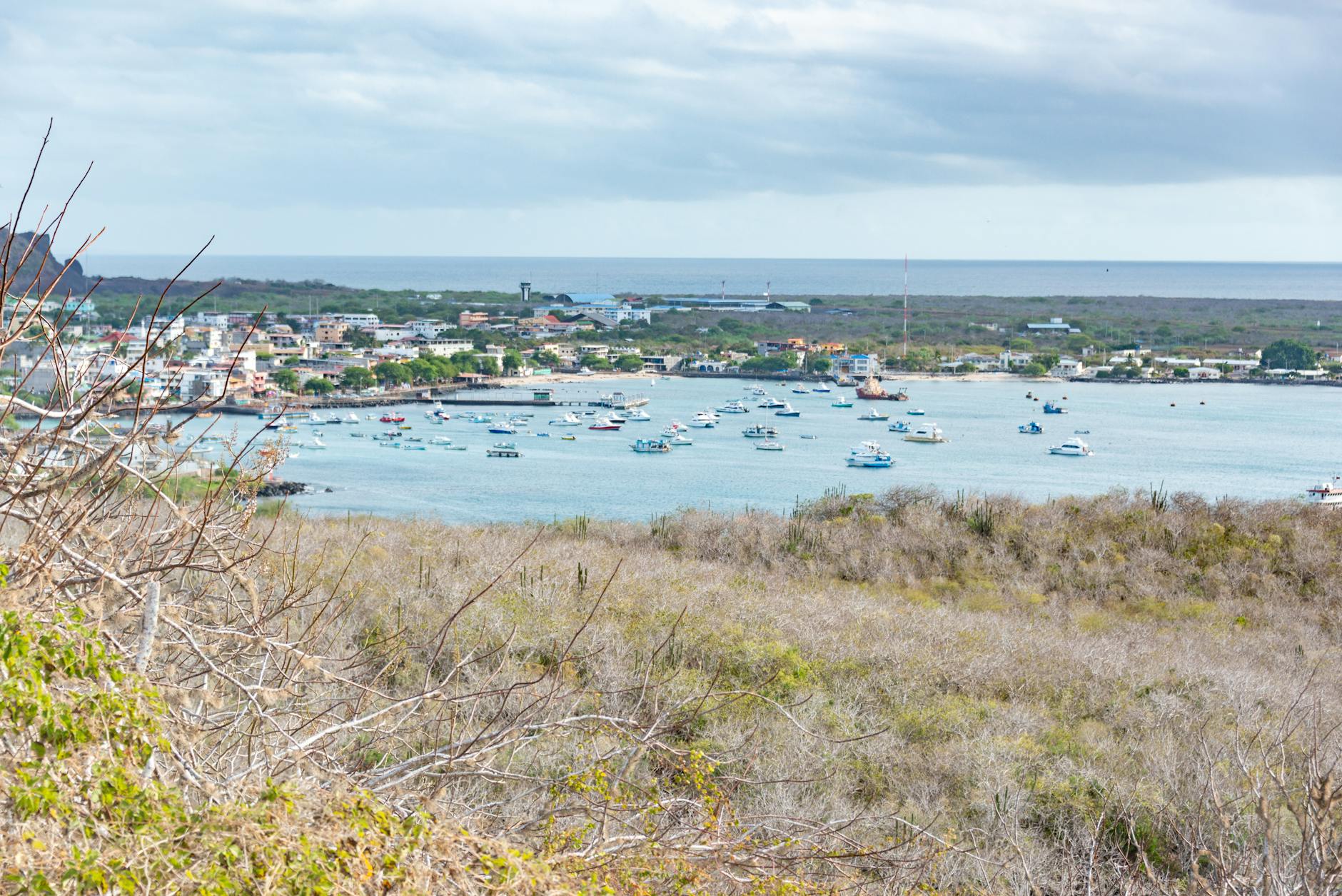 Photo: Diego F. Parra / Pexels
- Attractions
- 18
- Trip length
- 3-5 days
- Best season
- June–November (cool, dry, peak marine life)
Why Puerto Ayora
Built from cited sources · see the method · How we make our guides →
The town grew up around science. The Charles Darwin Research Station opened here in 1964, and by 1965 researchers had begun the tortoise-egg experiment that turned into the breeding program still running today; the first incubator-rearing structure was inaugurated in January 1970. The public campus is free — exhibition hall, native garden, a lookout above the cafeteria — while the Fausto Llerena breeding centre next door requires a guided, paid visit.
Conservation isn't an abstraction here, it's the civic religion. Coastal cleanups double as festivals, school groups walk the shoreline counting plastic, and the stained glass in the Parroquia Franciscana Santa Marianita shows Galápagos marine life instead of European saints — there's a pelican above the altar. Make of that what you will.
Eat badly and you'll only meet the visitor version of the town. The waterfront on Avenida Charles Darwin does sunset, grilled fish and yacht-watching; Charles Binford after 6 p.m. does plastic chairs, lobster and shouting across the street. On Sundays, islanders drive uphill to Bellavista and Santa Rosa for hornado and the kind of Ecuadorian cooking that has nothing to do with the sea.
Science You Can Walk Into
The Charles Darwin Research Station opened here in 1964, and its campus is still free to wander — exhibition hall, native garden, lookout, dry forest laid over old lava. The tortoise breeding route next door is guided and paid, which is the one part most visitors get wrong at the gate.Beaches That Belong to the Animals
Tortuga Bay sits 2.5 km from town down a paved path, and it splits in two: Playa Brava takes the open surf, Playa Mansa hides behind mangroves for kayaking and easy wildlife watching. Marine iguanas sprawl on the sand like they pay rent.The Punta Estrada Circuit
A $1 water taxi across Academy Bay drops you at a cluster most guidebooks flatten into one line — Playa de los Alemanes, the Pozas Salinas mangrove pools, Las Grietas, the shark channel boardwalk, and a 30-minute walk to Mirador de la Bahía. Half a day, no tour booking, no bus.Pelicans in Stained Glass
Puerto Ayora has almost no monumental architecture, which makes Parroquia Franciscana Santa Marianita worth the ten minutes. Its windows trade saints and lambs for marine iguanas, boobies, and a pelican above the altar — the archipelago's wildlife promoted to scripture.
Places to Visit
Not every monument, just the ones we'd walk you past ourselves.
-
Charles Darwin Research Station Entry is free — the hard sell at the gate is not. Puerto Ayora's science campus holds tortoise pens, a natural history archive and two local beaches.

- Galápagos Islands Sea lions nap on waterfront benches while conservation labs quietly run the archipelago behind the scenes in Puerto Ayora, Galapagos' busiest harbor town.
Neighborhoods
Where to wander, by quarter — each with its own rhythm.
Avenida Charles Darwin (the Malecón)
The waterfront spine, running from the Gus Angermeyer pier east toward the research station. Cafés, dive operators, art galleries and the fishermen's market, where daily cleaning attracts a standing audience of pelicans and one very entitled sea lion. Free theatre, better than most aquariums, and the busiest stretch of pavement on the island.Los Kioskos (Charles Binford)
Two blocks of open-air seafood kitchens that come alive after 6 p.m., when tables spill into a street closed to traffic. Grilled fish, encocado de langosta, ceviche, mountains of rice and fried plantain. Prices are posted, portions are large, and the volume is high — this is where people go after the tour boats dock.Punta Estrada
Across Academy Bay by $1 water taxi, and the quietest half-day in town. From the landing you can string together Playa de los Alemanes, the mangrove birdlife at Pozas Salinas, the shark channel boardwalk where white-tips rest in clear water, and Las Grietas — a volcanic fissure roughly 30 feet deep where fresh water floats on seawater. Las Grietas requires a licensed guide, a $10 fee, and a timed half-hour entry slot, so plan the order of stops.Pelican Bay
Just inland from the western waterfront, this is where the town's craft-beer and casual-dining scene has taken root, including Santa Cruz Brewery's microbrewery resto-pub. Less polished than the Malecón, more residential, and closer to how the working town actually eats and drinks.Barrio Miraflores
An interior neighbourhood of ordinary houses and extraordinary snacks. Local tourism material sends people here for clay-pan empanadas and traditional street food that never appears on a hotel recommendation card. No sea views, no English menus — that's rather the point.Avenida Baltra & Mercado Municipal
The working corridor: groceries, hardware, mopeds, and the municipal market where breakfast means tortilla de verde and coffee for a fraction of waterfront prices. Corviches, artisanal empanadas, fresh juice, and tripa mishki for the brave. Go before 9 a.m. if you want to see the town run its errands.Charles Darwin Station district
The eastern end of the avenue, where the road narrows into dry forest and lava. Beyond the exhibition hall and native gardens sit two beaches most visitors walk straight past: Playa de la Estación, and La Ratonera, which draws marine iguanas and the island's small local surf crowd.Bellavista and the highlands
Fifteen minutes uphill, the air turns damp and everything goes green — scalesia forest, farms, and giant tortoises wandering through pasture at El Chato. Lava tunnels, the twin craters at Los Gemelos, and panoramic views from Cerro Mesa are all up here. Sunday lunch in Bellavista or Santa Rosa is the local pattern; bring closed shoes for the mud.
Plan your trip
Before you go
- Getting There
- Almost everyone arrives via Seymour Airport on Baltra Island (GPS), 40 km north, with LATAM and Avianca flying in from Quito and Guayaquil. The official chain, unchanged for 2026: free airport bus to the Itabaca Channel (10 min), $1 ferry across (10 min), then a $2 public bus (45 min) or a white pickup taxi at roughly $25 for up to four people. Arriving instead at San Cristóbal (SCY) means a $30 speedboat, 07:00–09:30, two to three hours across open water.
- Getting Around
- There is no metro, no tram, and no transit card here — in 2026 Puerto Ayora still runs on walking, white pickup taxis at a flat $1.50 in town, and harbor water taxis at about $1 across Academy Bay. Most hotels, agencies, and restaurants sit within a few blocks of Avenida Charles Darwin and the waterfront. Inter-island speedboats leave Gus Angermeyer pier at $30 per person: Santa Cruz to San Cristóbal or Isabela departs 13:45, Floreana runs Tuesdays and Thursdays at 08:00. Bikes work well in town and along the protected cycle lane on the Itabaca road.
- Climate & Best Time
- Two seasons, not four. December–May is warm and wet, with daytime highs of 25–30°C, warmer water, calmer seas, and February the wettest month at about 132 mm. June–November brings the garúa: cooler air near 23–26°C, grey drizzle in the highlands, and very little rain in town — September averages 5.4 mm and is the coolest month. Come June–November for marine life and dry streets, December–May for snorkeling comfort.
- Money & Fees
- Ecuador uses the U.S. dollar, and two charges are unavoidable in 2026: the $20 Transit Control Card bought at the mainland airport and the $200 national park entry fee for most foreign visitors aged 12 and over, with reduced rates for children, CAN/Mercosur nationals, and residents. Cards work at hotels and larger operators, but ferries, taxis, kiosks, and small agencies want cash. Bring small denominations — nobody at the Itabaca crossing is breaking a fifty. Tipping runs around 10% for good restaurant service.
- Safety & Connectivity
- Ecuador sits at Level 2 on the U.S. advisory scale, though Puerto Ayora's real risks are logistical rather than criminal: verify your boat operator is licensed, since not every vessel meets international safety standards, and keep documents and cash close during the Baltra–Itabaca transfer. Medical care on Santa Cruz is limited and anything serious means evacuation to the mainland, so travel insurance covering it is not optional. Mobile data drops out often; Claro has a storefront on Av. Baltra, weekdays 9:00–18:00. Emergencies: 911.
A Town Built on Lava, Named for a President, Rebuilt by Science
From an empty volcanic shoreline to the capital of the world's most watched archipelago — in barely a century
- c. 8 million years ago
The Hotspot Builds Santa Cruz
The Nazca Plate drifts east over a stationary plume of magma, and Santa Cruz rises out of the Pacific in successive shield-volcano pulses. Academy Bay — the flooded notch on the southern coast where Puerto Ayora now sits — is a collapsed remnant of that construction. Geologists date the island's oldest exposed lavas well before the arrival of any bird, reptile, or human. Everything that came later had to swim, fly, or raft here.
- 1535
A Bishop Drifts Into the Islands
Fray Tomás de Berlanga, Bishop of Panama, is sailing to Peru when the wind dies and the current carries his ship west for days. His crew lands desperate for water, chews cactus pads for moisture, and finds giant tortoises and tame birds instead of rivers. His letter to Charles V is the first written record of the archipelago and reads like a complaint. Nobody thought to settle here for another four hundred years.
- 1684
Buccaneers Chart the Enchanted Isles
English pirates raiding the Spanish Main use the islands as a hideout, and navigator Ambrose Cowley draws the first chart of the group, naming islands after English nobles who had never seen them. Spanish sailors had already called them Las Encantadas — the bewitched ones — because currents and fog made them seem to move. Santa Cruz gets no settlement, only anchorages and stolen fresh meat.
- 1793
Whalers Discover a Living Larder
Captain James Colnett surveys the islands for the British whaling fleet and reports something irresistible: tortoises that survive a year in a ship's hold without food or water, staying edible the whole time. Over the following century, crews remove an estimated 100,000 to 200,000 of them. Whole populations vanish. Every conservation program later run out of Puerto Ayora is, in some sense, an attempt to undo those decades.
- 1832
Ecuador Claims the Archipelago
Twelve days after the young republic sorts out its own borders, General José de Villamil raises the flag on Floreana and names the group Archipiélago de Colón. The claim is administrative rather than military — there was nobody here to conquer. Santa Cruz stays empty scrubland and lava for another ninety years, a place on a map with no address.
- 1835
Charles Darwin, Five Weeks Ashore
The HMS Beagle spends thirty-five days in the archipelago and its 26-year-old naturalist collects finches so carelessly labelled that he later needs the ship's crew to sort out which island each came from. Darwin never set foot on the ground where Puerto Ayora stands — the town would not exist for another ninety-one years. Yet the research station, the avenue, the whole economic logic of the town carries his name. A place founded on someone else's five weeks of note-taking.
Show the full timeline (27 moments)
- 1879
Isidro Ayora, the Absent Namesake
Born in Loja, Ayora trained as a physician before becoming president in 1926, and his administration pushed to develop Ecuador's forgotten territories — including a scattering of huts on Academy Bay. Settlers named the anchorage for him in gratitude for official recognition and supply runs. According to local accounts he never visited. The largest town in the Galápagos is named after a man who saw it only on paper.
- 1926
Norwegians Bet on a Fish Cannery
A group of Norwegian colonists lands on the southern coast of Santa Cruz with equipment for a canning operation and dreams of an agricultural commune. The soil near the shore is lava rubble, fresh water barely exists, and the venture collapses within a few years. Some settlers stayed anyway, moving up into the wetter highlands to farm. That stubbornness is the actual founding of Puerto Ayora.
- 1935
The Angermeyer Brothers Come Ashore
Four brothers from Hamburg sail to the Galápagos to escape the politics of 1930s Germany and end up living in caves on the rocks across Academy Bay from the settlement. They fished, built boats from salvage, and eventually ran some of the first tourist charters in the islands. Their descendants still operate hotels and yachts in Puerto Ayora, and the peninsula opposite the pier still carries the family's presence. Local accounts of the early cave years vary in the details; the boats and the surname are documented.
- 1941
The Americans Build an Airfield on Baltra
With the Panama Canal to defend, the U.S. builds an air base on the flat scrap of island just north of Santa Cruz, pouring a runway, barracks, and a fuel depot. Puerto Ayora becomes a minor supply and communication stop — no combat, just traffic. When the Americans left in 1946, they abandoned the infrastructure, and that runway became the archipelago's main civilian airport. Every tourist who flies into Santa Cruz today lands on a wartime leftover.
- 1959
Ninety-Seven Percent Becomes National Park
On the centenary of On the Origin of Species, Ecuador declares 97% of the archipelago's land area a national park and the Charles Darwin Foundation is chartered in Brussels under Belgian law. Two decisions taken thousands of kilometres away that would determine what Puerto Ayora was allowed to become. The town's boundaries were effectively frozen that year — it can only grow inward.
- 1964
The Research Station Opens on Academy Bay
The Charles Darwin Research Station is inaugurated on the eastern edge of town, bringing laboratories, a library, and foreign scientists to a village of a few hundred fishermen and farmers. Overnight, Puerto Ayora acquires an economy that has nothing to do with catching fish. Kids who grew up hauling nets ended up working as naturalist guides. The station remains free to enter — a rarity in a place where almost everything else has a fee.
- 1965
The Tortoise Breeding Program Begins
Scientists at the station start collecting eggs from islands where introduced rats and pigs eat every hatchling, incubating them in Puerto Ayora and raising the young in pens until their shells are too hard to crush. The first repatriations to Española involve fourteen surviving adults. Their descendants now number over two thousand. It is the single most successful reptile recovery program anywhere, and it runs out of a compound five minutes' walk from the town's bars.
- 1972
Lonesome George Moves to Town
A snail biologist working on Pinta Island finds a single male tortoise on an island everyone assumed had been stripped bare by whalers and goats. He is shipped to the breeding centre at Puerto Ayora, and for forty years scientists try every trick to get him to breed. Nothing works. The last Pinta tortoise on Earth spends four decades in a pen in the middle of a tourist town, watched by millions of people.
- 1973
Capital of the Canton
Galápagos becomes Ecuador's twenty-second province and Santa Cruz is organised as a canton with Puerto Ayora as its seat. Administration, courts, and municipal budgets arrive; so do mainland migrants from Manabí and Guayas looking for work. The population begins the climb that turns a village into the archipelago's largest settlement.
- 1978
UNESCO Puts the Islands on the First List
The Galápagos are inscribed among the very first twelve World Heritage Sites, alongside the Pyramids and Aachen Cathedral. International money follows for docks, water systems, and visitor infrastructure, most of it landing in Puerto Ayora. The designation also brings permanent outside scrutiny. From this point on, every decision about a new hotel or a new road here is watched from Paris.
- 1982–1983
El Niño Cooks the Ocean
Sea temperatures rise several degrees and the cold, nutrient-rich Cromwell Current stops delivering. Marine iguanas starve on the rocks, seabird colonies fail entirely, and an estimated 70% of the archipelago's penguins die. Storm surge chews at Puerto Ayora's waterfront while rain turns the highland farms unexpectedly lush. The town learned that year that a good year for the farmers is a catastrophe for the sea.
- 1984
Biosphere Reserve Status
UNESCO adds a Biosphere Reserve designation, a framework built around the idea that people and protected nature can share a territory rather than one excluding the other. For Puerto Ayora that is not an abstraction — the town sits inside the park, and the boundary runs along the edge of the last street. Conservation policy here has always had to account for the fact that thousands of people live in the middle of the exhibit.
- 1995
The Sea Cucumber Wars
Asian demand sends sea cucumber prices soaring and local fishermen strip the seabed faster than any quota can track. When the park closes the fishery, protesters occupy the Charles Darwin Research Station and blockade offices in Puerto Ayora, at one point threatening the captive tortoises. The confrontation returns in 2004. It remains the sharpest fault line in island life: the science campus and the fishing pier are 400 metres apart and do not always agree.
- 1998
The Special Law Locks the Door
Ecuador passes the Ley Especial de Galápagos, creating a marine reserve of 133,000 square kilometres and — more consequential for daily life here — a residency system. You now need permits to live, work, or open a business in the islands. Puerto Ayora becomes the administrative nerve centre enforcing who gets to stay. A town founded by anyone who could sail here now controls entry by paperwork.
- 2000
Dollarization Hits an Island Economy
Ecuador abandons the sucre for the U.S. dollar after a banking collapse, and prices in Puerto Ayora — where nearly every tomato, nail, and litre of fuel arrives by cargo ship from Guayaquil — settle at a permanent premium over the mainland. Wages in tourism absorb it; wages in fishing and farming do not. The cost of a beer on Avenida Charles Darwin still tells that story.
- 2001
The Jessica Runs Aground
The tanker MV Jessica hits a reef off San Cristóbal and spills roughly 150,000 gallons of diesel and bunker fuel. Currents push the sheen west toward Santa Cruz, and Puerto Ayora becomes the staging ground for booms, volunteers, and wildlife rescue. Shifting winds spared the worst of it, though sea lion and marine iguana mortality on Santa Fe ran high for a year afterward. A near-miss that permanently changed how fuel moves through the archipelago.
- 2007
Listed as World Heritage in Danger
UNESCO flags the islands as at risk from invasive species, unchecked immigration, and tourist numbers that had roughly tripled in fifteen years. Ecuador declares the archipelago at risk and starts culling goats, tightening flights, and capping residency. The listing is lifted in 2010 after visible progress. Puerto Ayora spent those three years being told, in public, that it was growing too fast.
- 24 June 2012
Lonesome George Dies in His Pen
The keeper finds him stretched toward his waterhole one Sunday morning. A subspecies ends in a concrete-walled enclosure a few hundred metres from a town full of souvenir shops selling his face. He was taxidermied in New York and returned to Puerto Ayora in 2017, where he now stands in a climate-controlled hall at the research station. Standing in front of him is a strange, quiet experience — the room is cold, and he is the only thing in it.
- 2012
Fire in the Highlands
Flames run through more than a thousand hectares of the Santa Cruz highlands, the same zone whose fog-drip and rainfall recharge the brackish aquifer Puerto Ayora drinks from. The municipality rations water while volunteers and park rangers cut firebreaks. Afterwards came reforestation with native scalesia and a harder look at how a town of 15,000 gets its water from cracks in volcanic rock.
- 2020
The Boats Stop
Airports close, cruise ships anchor empty, and a town where roughly four in five jobs depend on visitors goes quiet for the better part of a year. Families returned to fishing and highland farming; some left for the mainland. Researchers, meanwhile, got an accidental control experiment — months of near-zero vessel traffic in the marine reserve. The recovery came fast, but the memory of that silence still shapes how people here talk about depending on one industry.
- 2022
The Marine Reserve Grows by 60,000 km²
Ecuador signs the Hermandad Reserve into existence, extending protection along the migratory corridor that hammerhead sharks and sea turtles use to reach Cocos Island. It is the largest expansion since 1998 and was negotiated partly through a debt-for-nature swap. The scientists who modelled those migration routes work out of the labs on the east end of Puerto Ayora. A town of one main street, arguing about 60,000 square kilometres of ocean.
Who lived here
-
Naturalist · 1809–1882
Charles Darwin
Namesake — never set foot on Santa Cruz
The town's main avenue, its research station and its tourist economy all carry his name, and he never landed here. The Beagle stopped at San Cristóbal, Floreana, Isabela and Santiago in 1835; Santa Cruz was passed over. He'd probably find the irony less interesting than the tortoises being bred half a kilometre from the street sign.
-
Settler and boatman · 1919–2008
Karl Angermeyer
Settled at Academy Bay in 1937
One of four German brothers who sailed from Hamburg and ended up building houses out of lava rock on the far side of Academy Bay, at a time when Puerto Ayora was a handful of families. He fished, ferried scientists, and kept marine iguanas that came when called — the press eventually labelled him Ecuador's Robinson Crusoe. The pier tourists queue at today is named after his brother Gus.
-
Wildlife photographer · born 1953
Tui De Roy
Raised at Academy Bay from age two
Her Belgian parents moved to Santa Cruz in 1955 and raised her without electricity in a stone house near the bay, which is how a child ends up learning to read the tide before learning arithmetic. She turned that upbringing into decades of Galápagos photography that shaped how the outside world pictures these islands. She has argued, publicly and repeatedly, that the archipelago's real threat is not the visitor but the pace at which the towns grow to serve them.
-
Park ranger and tortoise keeper · 20th century–present
Fausto Llerena
Worked at the Puerto Ayora breeding centre from 1971
For four decades he fed, cleaned up after and shared a paddock with Lonesome George, the last Pinta Island tortoise, who died in 2012 without leaving offspring despite everyone's best efforts. The breeding centre beside the Darwin Station now carries his name. If you visit it, you're standing in the place where a species ended and several others were pulled back from the same edge.
Where to Eat
Where locals actually book dinner — not the tourist menus.
-
Los Kioskos on Calle Charles Binford
After dark the street closes and plastic tables spill across the asphalt under strings of bulbs. This is where locals and crew eat: whole grilled fish, lobster in season, langostinos by weight. Prices are posted, portions are absurd, and the atmosphere costs nothing extra.
-
Ceviche de camarón
Ecuadorian ceviche is not Peruvian ceviche — the shrimp arrive poached in a cold tomato-and-lime broth, sweetened with orange, and served with popcorn and chifles to throw in yourself. Order it at breakfast and nobody will look at you strangely.
-
Brujo (Galápagos scorpionfish)
An ugly reef fish with dense white flesh that holds up to a hot grill better than almost anything else landed here. Ask which fish came in that morning at the market rather than ordering blind; the answer changes daily and the freshest option is always the right one.
-
Encebollado
Albacore, yuca, and pickled red onion in a cumin-heavy broth, eaten mid-morning and reputed across Ecuador to fix a hangover. On the islands it's the closest thing to a national breakfast, and the small comedores inland from the Malecón do it better than the waterfront.
-
Encocado de pescado
Coastal Ecuador's coconut-milk fish stew, brought over from Esmeraldas, thickened with peanut in some kitchens and served over rice with patacones. Rich enough that you will skip lunch afterward.
-
Bolón de verde
A fist of mashed green plantain packed with cheese or chicharrón, fried, and eaten with coffee before a boat departure. Cheap, dense, and the reason nobody on a 07:00 speedboat looks hungry.
-
The fish market on Avenida Charles Darwin
Not a restaurant, but skip it and you miss the best free theater in town. Fishermen fillet the morning catch while pelicans crowd the counter and a sea lion muscles in at the fishmonger's feet, entirely unbothered by anyone's opinion on the matter.
-
Café from the highlands
Santa Cruz farms grow coffee in the humid interior around Bellavista and Santa Rosa, and several highland farms press cane and roast beans for visitors. Buy it there rather than in a Malecón gift shop — same beans, half the markup, and you get to see the trapiche working.
Insider tips
Small things that change how the city treats you.
Take The Water Taxi
A one-dollar panga from the main pier crosses Academy Bay to Punta Estrada, where Playa de los Alemanes, Las Grietas, Pozas Salinas and the Mirador de la Bahía all sit within a 30-minute walk of each other. Cheapest half-day in the islands.Carry Small Bills
Ecuador runs on US dollars, and the ferry across Itabaca Channel, the taxis, and the kiosk dinners all want cash in small denominations. Cards work at hotels and the bigger restaurants on Avenida Charles Darwin, and almost nowhere else.Skip The Private Transfer
From Baltra airport the free shuttle bus, the $1 barge, and the $2 public bus get you to town for about $3 in roughly 90 minutes. The white pickup taxi costs $25 for up to four people and saves maybe fifteen minutes.Eat On Charles Binford
Los Kioskos fills the street with plastic tables after dark — grilled fish, lobster, ceviche, plantains, and a fraction of the waterfront prices. For breakfast, the municipal market does tortilla de verde and corviches while the town is still waking up.Beat The Tortuga Bay Heat
The 2.5 km paved path from town has no shade and closes to entries in the late afternoon. Walk it before 9am, and keep going past the surf-swept Playa Brava to Playa Mansa, the calm mangrove-backed cove where the kayaks and the sharks are.Expect Patchy Signal
Mobile data and wifi in Galápagos are slow and unreliable compared with mainland Ecuador, so download maps and boarding passes in Quito or Guayaquil. There's a Claro shop on Av. Baltra, open weekdays 9:00–18:00, if you need a local SIM.Check The Operator's Licence
Boat safety standards vary widely and medical care on Santa Cruz is limited — anything serious means an evacuation flight. Book day trips and dives through licensed operators, and remember Las Grietas requires a naturalist guide and timed entry.
Gallery
The city, as it actually looks.


Frequently asked
Is Puerto Ayora worth visiting?
Yes, and it's the one Galápagos town where you can see world-class wildlife without booking a cruise. Sea lions sleep on the malecón benches, pelicans hang around the fish market waiting for scraps, and white-tip reef sharks rest in a channel you can watch from a boardwalk. It's also the archipelago's largest town, so the hotels, dive shops, ferries and day boats are all here.
How many days should I spend in Puerto Ayora?
Three to five days is the sweet spot. Two days covers the town itself — Charles Darwin Research Station, Tortuga Bay, the Punta Estrada cluster and Laguna de las Ninfas — and each extra day buys a highland trip to El Chato and Los Gemelos, or a boat day to North Seymour, Santa Fe, South Plaza or Bartolomé. Under three days and you'll spend a disproportionate share of your trip in transit from Baltra.
How do you get from Baltra airport to Puerto Ayora?
Four legs, about 90 minutes, roughly $3 by public transport. A free shuttle runs from the terminal to the Itabaca Channel in 10 minutes, the barge across costs about $1, and from the far shore a public bus reaches Puerto Ayora in about 45 minutes for $2. A white pickup taxi does the same stretch for about $25 flat for up to four passengers.
How much does it cost to enter the Galápagos?
Budget $220 before you've bought anything. The Transit Control Card is $20, and the protected-areas entry fee is $200 for most foreign visitors aged 12 and up, with reduced rates for children, CAN and Mercosur nationals and Ecuadorian residents. Both are collected at the airport, so keep the cash accessible.
Is the Charles Darwin Research Station free?
The public campus is free and open daily — exhibition hall, native garden, interpretation spaces and the small beaches beside it. The adjacent Fausto Llerena breeding centre, where the giant tortoises are, is a separate guided and paid visit. The station opened in 1964 and started its tortoise-egg experiment the following year.
Is Puerto Ayora safe for tourists?
Broadly yes — Ecuador carries a Level 2 'exercise increased caution' US advisory, but the mainland's problems don't map onto a small island town. The real risks here are logistical: keep documents and cash secure during the Baltra transfer, use licensed boat operators, and don't count on fast specialist medical care. Ecuador's emergency number is 911, with a Galápagos dispatch centre.
What is the best time of year to visit Puerto Ayora?
It depends on whether you'd rather swim or dive. December to May is the warm wet season — 25–30°C, sunnier, calmer seas, warmer water. June to November brings garúa drizzle in the highlands, air around 23–26°C, colder and richer water, and the strongest marine-life activity. September is the driest month in town, with about 5 mm of rain; February is the wettest, at roughly 132 mm.
How do you travel from Puerto Ayora to Isabela or San Cristóbal?
Public speedboats leave from Gus Angermeyer pier for $30 per person each way, taking about two hours. Santa Cruz departures for both San Cristóbal and Isabela run in the 13:45–16:00 window; return boats leave early morning. Floreana runs Tuesdays and Thursdays only. Seas are noticeably rougher July through December.
Can you see giant tortoises near Puerto Ayora without a tour?
Yes. The El Chato reserve and neighbouring highland farms sit about an hour's drive inland, and several accept walk-ins with boot rental included — a taxi will wait for you. Tortoises there are wild and move between properties, so what you see is genuinely wild behaviour rather than a pen. Cerro Mesa and the Los Gemelos craters are on the same road.
Pick up where you left off
Saved and recently read places — kept on this device only.
Photo credits (13)
- Diego F. Parra — Pexels License (https://www.pexels.com/license/) — Source: https://www.pexels.com/photo/18761684/
- (Grapsus grapsus) Puerto Ayora Galápagos Islands pic. a3 — David Adam Kess — CC BY-SA 4.0 (https://creativecommons.org/licenses/by-sa/4.0/) — Source: https://commons.wikimedia.org/wiki/File:(Grapsus_grapsus)_Puerto_Ayora_Galápagos_Islands_pic._a3.JPG
- (Galapagos Cottages) Tortuga Bay, Santa Cruz Island Galápagos (Puerto Ayora) — David Adam Kess — CC BY-SA 4.0 (https://creativecommons.org/licenses/by-sa/4.0/) — Source: https://commons.wikimedia.org/wiki/File:(Galapagos_Cottages)_Tortuga_Bay,_Santa_Cruz_Island_Galápagos_(Puerto_Ayora).JPG
- Bahía Tortuga Puerto Ayora Galapagos — David Adam Kess — CC BY-SA 3.0 (https://creativecommons.org/licenses/by-sa/3.0/) — Source: https://commons.wikimedia.org/wiki/File:Bahía_Tortuga_Puerto_Ayora_Galapagos.JPG
- (Zalophus wollebaeki) Puerto Ayora main water taxi dock , three Galápagos Sea Lions — David Adam Kess — CC BY-SA 4.0 (https://creativecommons.org/licenses/by-sa/4.0/) — Source: https://commons.wikimedia.org/wiki/File:(Zalophus_wollebaeki)_Puerto_Ayora_main_water_taxi_dock_,_three_Galápagos_Sea_Lions.JPG
- (Grapsus grapsus) Puerto Ayora Galápagos Islands pic. a1 — David Adam Kess — CC BY-SA 4.0 (https://creativecommons.org/licenses/by-sa/4.0/) — Source: https://commons.wikimedia.org/wiki/File:(Grapsus_grapsus)_Puerto_Ayora_Galápagos_Islands_pic._a1.JPG
- ) Seesaw at the Puerto Ayora Playground, Island of Santa Cruz, Galapagos — David Adam Kess — CC BY-SA 4.0 (https://creativecommons.org/licenses/by-sa/4.0/) — Source: https://commons.wikimedia.org/wiki/File:)_Seesaw_at_the_Puerto_Ayora_Playground,_Island_of_Santa_Cruz,_Galapagos.JPG
- (Grapsus grapsus) Puerto Ayora Galápagos Islands pic. a4 — David Adam Kess — CC BY-SA 4.0 (https://creativecommons.org/licenses/by-sa/4.0/) — Source: https://commons.wikimedia.org/wiki/File:(Grapsus_grapsus)_Puerto_Ayora_Galápagos_Islands_pic._a4.JPG
- A sleeping (Zalophus wollebaeki) Puerto Ayora Galapagos — David Adam Kess — CC BY-SA 4.0 (https://creativecommons.org/licenses/by-sa/4.0/) — Source: https://commons.wikimedia.org/wiki/File:A_sleeping_(Zalophus_wollebaeki)_Puerto_Ayora_Galapagos.JPG
- (Grapsus grapsus) Puerto Ayora Galápagos Islands pic. a2 — David Adam Kess — CC BY-SA 4.0 (https://creativecommons.org/licenses/by-sa/4.0/) — Source: https://commons.wikimedia.org/wiki/File:(Grapsus_grapsus)_Puerto_Ayora_Galápagos_Islands_pic._a2.JPG
- (at night) Puerto Ayora, Island of Santa Cruz — David Adam Kess — CC BY-SA 4.0 (https://creativecommons.org/licenses/by-sa/4.0/) — Source: https://commons.wikimedia.org/wiki/File:(at_night)_Puerto_Ayora,_Island_of_Santa_Cruz.JPG
- A bird on the dock at Puerto Ayora Galapagos black and white at Sunset — David Adam Kess — CC BY-SA 4.0 (https://creativecommons.org/licenses/by-sa/4.0/) — Source: https://commons.wikimedia.org/wiki/File:A_bird_on_the_dock_at_Puerto_Ayora_Galapagos_black_and_white_at_Sunset.JPG
- (Zalophus wollebaeki) main water taxi dock at Puerto Ayora, three Galápagos Sea Lions — David Adam Kess — CC BY-SA 4.0 (https://creativecommons.org/licenses/by-sa/4.0/) — Source: https://commons.wikimedia.org/wiki/File:(Zalophus_wollebaeki)_main_water_taxi_dock_at_Puerto_Ayora,_three_Galápagos_Sea_Lions.JPG
Photos may have been resized or cropped.